File:2021-04-04 Gedenktafel Fischerhof 04.JPG
Jump to navigation
Jump to search

Size of this preview: 400 × 600 pixels. Other resolutions: 160 × 240 pixels | 320 × 480 pixels | 512 × 768 pixels | 682 × 1,024 pixels | 1,794 × 2,691 pixels.
Original file (1,794 × 2,691 pixels, file size: 2.06 MB, MIME type: image/jpeg)
Captions
Captions
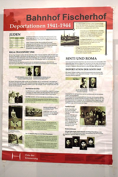
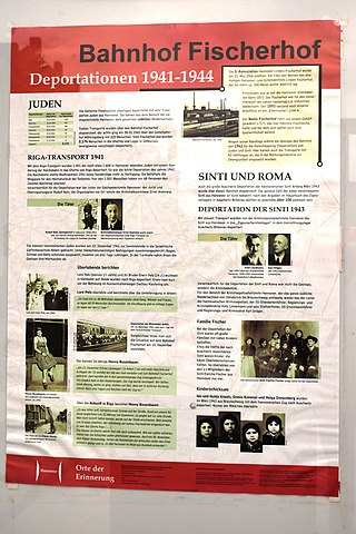
Information board at the Hannover-Linden/Fischerhof S-Bahn station, located east of the former Linden Fischerhof station with the memorial to all those persecuted under National Socialism
Summary
[edit]
| Description |
Deutsch: Informationstafel an der 2006 eröffneten S-Bahnstation Hannover-Linden/Fischerhof, die etwa 300 Meter östlich des ehemaligen Personen- und Güterbahnhofs Linden Fischerhof liegt, neben dessen Eingang vom Niedersächsischen Verband deutscher Sinti das Mahnmal für alle Verfolgten des Nationalsozialismus aufgestellt wurde. Von 1941 bis 1944 wurden vom Bahnhof Linden Fischerhof aufgrund ethnischer Zuschreibungen ausgesonderte Frauen, Männer, Kinder und ganze Familien aus Hannover und Südniedersachsen in die Vernichtungslager im Osten des Deutschen Reiches abtransportiert. Nur wenige überlebten und konnten über die Geschehnisse berichten.
English: Information board at the Hannover-Linden/Fischerhof S-Bahn station, which opened in 2006 and is located about 300 metres east of the former Linden Fischerhof passenger and freight station, next to whose entrance the Lower Saxony Association of German Sinti erected the memorial to all those persecuted under National Socialism. From 1941 to 1944, women, men, children and entire families from Hannover and southern Lower Saxony were transported from Linden Fischerhof station to the extermination camps in the east of the German Reich on the basis of ethnic classification. Only a few survived and were able to give an account of what happened. |
||||||||||||||||
| Date | |||||||||||||||||
| Source | Own work | ||||||||||||||||
| Author |
|
||||||||||||||||
| Camera location | | View this and other nearby images on: OpenStreetMap |
|---|
Licensing
[edit]
I, the copyright holder of this work, hereby publish it under the following license:
This file is licensed under the Creative Commons Attribution-Share Alike 4.0 International license.
- You are free:
- to share – to copy, distribute and transmit the work
- to remix – to adapt the work
- Under the following conditions:
- attribution – You must give appropriate credit, provide a link to the license, and indicate if changes were made. You may do so in any reasonable manner, but not in any way that suggests the licensor endorses you or your use.
- share alike – If you remix, transform, or build upon the material, you must distribute your contributions under the same or compatible license as the original.
File history
Click on a date/time to view the file as it appeared at that time.
| Date/Time | Thumbnail | Dimensions | User | Comment | |
|---|---|---|---|---|---|
| current | 07:40, 8 April 2021 | | 1,794 × 2,691 (2.06 MB) | Bärbel Miemietz (talk | contribs) | {{Information |Description={{de|Informationstafel an der 2006 eröffneten S-Bahnstation Hannover-Linden/Fischerhof, die etwa 300 Meter östlich des ehemaligen Personen- und Güterbahnhofs Linden Fischerhof liegt, neben dessen Eingang vom Niedersächsischen Verband deutscher Sinti das Mahnmal für alle Verfolgten des Nationalsozialismus aufgestellt wurde. Von 1941 bis 1944 wurden vom Bahnhof Linden Fischerhof aufgrund ethnischer Zuschreibungen ausgesonderte Frauen, Männer, Kinder und ganze Familien... |
You cannot overwrite this file.
File usage on Commons
There are no pages that use this file.