File:2020 PAGASA Rolly forecast map.png
Jump to navigation
Jump to search

Size of this preview: 776 × 600 pixels. Other resolutions: 311 × 240 pixels | 621 × 480 pixels | 994 × 768 pixels | 1,280 × 989 pixels | 2,560 × 1,978 pixels | 3,300 × 2,550 pixels.
Original file (3,300 × 2,550 pixels, file size: 266 KB, MIME type: image/png)
Captions
Captions
Add a one-line explanation of what this file represents
Summary
[edit]
| Description |
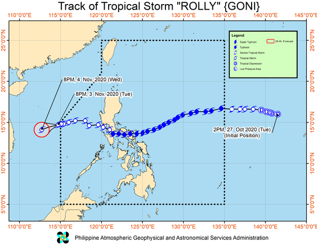
English: PAGASA's forecast map of Northwest Pacific typhoon Rolly #1. |
| Date | |
| Source | http://bagong.pagasa.dost.gov.ph/tropical-cyclone/severe-weather-bulletin/2 http://pubfiles.pagasa.dost.gov.ph/tamss/weather/track.png |
| Author | PAGASA |
Licensing
[edit]
| This work is in the public domain in the Philippines and possibly other jurisdictions because it is a work created by an officer or employee of the Government of the Philippines or any of its subdivisions and instrumentalities, including government-owned and/or controlled corporations, as part of their regularly prescribed official duties; consequently, any work is ineligible for copyright under the terms of Part IV, Chapter I, Section 171.11 and Part IV, Chapter IV, Section 176 of Republic Act No. 8293 and Republic Act No. 10372, as amended, unless otherwise noted. However, in some instances, the use of this work in the Philippines or elsewhere may be regulated by this law or other laws.
|

|
File history
Click on a date/time to view the file as it appeared at that time.
| Date/Time | Thumbnail | Dimensions | User | Comment | |
|---|---|---|---|---|---|
| current | 15:38, 3 November 2020 | | 3,300 × 2,550 (266 KB) | Cewbot (talk | contribs) | Import PAGASA tropical cyclone forecast map of Northwest Pacific tropical storm Rolly #24. At 10:00 AM today, the center of Tropical Storm "ROLLY" was estimated based on all available data at 540 km West of Subic, Zambales (14.8 °N, 115.3 °E ) (2020-11-03 03:00 UTC) |
| 09:35, 3 November 2020 |  | 3,300 × 2,550 (265 KB) | Cewbot (talk | contribs) | Import PAGASA tropical cyclone forecast map of Northwest Pacific tropical storm Rolly #24. At 10:00 AM today, the center of Tropical Storm "ROLLY" was estimated based on all available data at 540 km West of Subic, Zambales (14.8 °N, 115.3 °E ) (2020-11-03 03:00 UTC) | |
| 03:35, 3 November 2020 |  | 3,300 × 2,550 (274 KB) | Cewbot (talk | contribs) | Import PAGASA tropical cyclone forecast map of Northwest Pacific tropical storm Rolly #24. At 10:00 AM today, the center of Tropical Storm "ROLLY" was estimated based on all available data at 540 km West of Subic, Zambales (14.8 °N, 115.3 °E ) (2020-11-03 03:00 UTC) | |
| 21:35, 2 November 2020 |  | 3,300 × 2,550 (292 KB) | Cewbot (talk | contribs) | Import PAGASA tropical cyclone forecast map of Northwest Pacific tropical storm Rolly #23. At 10:00 PM today, the center of Tropical Storm "ROLLY" was estimated based on all available data at 365 km West of Iba, Zambales (15.2 °N, 116.6 °E ) (2020-11-02 15:00 UTC) | |
| 16:35, 2 November 2020 |  | 3,300 × 2,550 (528 KB) | Cewbot (talk | contribs) | Import PAGASA tropical cyclone forecast map of Northwest Pacific tropical storm Rolly #23. At 10:00 PM today, the center of Tropical Storm "ROLLY" was estimated based on all available data at 365 km West of Iba, Zambales (15.2 °N, 116.6 °E ) (2020-11-02 15:00 UTC) | |
| 08:35, 2 November 2020 |  | 3,300 × 2,550 (514 KB) | Cewbot (talk | contribs) | Import PAGASA tropical cyclone forecast map of Northwest Pacific tropical storm Rolly #22. At 10:00 AM today, the center of Tropical Storm "ROLLY" was estimated based on all available data at 195 km West of Subic, Zambales (14.8 °N, 118.5 °E ) (2020-11-02 03:00 UTC) | |
| 03:36, 2 November 2020 |  | 3,300 × 2,550 (515 KB) | Cewbot (talk | contribs) | Import PAGASA tropical cyclone forecast map of Northwest Pacific tropical storm Rolly #22. At 10:00 AM today, the center of Tropical Storm "ROLLY" was estimated based on all available data at 195 km West of Subic, Zambales (14.8 °N, 118.5 °E ) (2020-11-02 03:00 UTC) | |
| 21:35, 1 November 2020 |  | 3,300 × 2,550 (510 KB) | Cewbot (talk | contribs) | Import PAGASA tropical cyclone forecast map of Northwest Pacific tropical storm Rolly #21. At 4:00 AM today, the center of Tropical Storm "ROLLY" was estimated based on all available data at 100 km West Southwest of Subic Bay (14.6 °N, 119.4 °E ) (2020-11-01 21:00 UTC) | |
| 18:36, 1 November 2020 |  | 3,300 × 2,550 (500 KB) | Cewbot (talk | contribs) | Import PAGASA tropical cyclone forecast map of Northwest Pacific tropical storm Rolly #20. At 1:00 AM today, the center of Tropical Storm "ROLLY" was estimated based on all available data at 155 km West of Sangley Pt, Cavite or 95 km West Southwest of Subic Bay (14.5 °N, 119.5 °E ) (2020-11-01 18:00 UTC) | |
| 16:34, 1 November 2020 |  | 3,300 × 2,550 (492 KB) | Cewbot (talk | contribs) | Import PAGASA tropical cyclone forecast map of Northwest Pacific tropical storm Rolly #19. At 10:00 PM today, the center of Tropical Storm "ROLLY" was estimated based on all available data at 150 km Northwest of Calapan City, Oriental Mindoro or 90 km West Southwest of Sangley Pt, Cavite (14.3 °N, 120.1 °E ) (2020-11-01 15:00 UTC) |
You cannot overwrite this file.
File usage on Commons
There are no pages that use this file.
File usage on other wikis
The following other wikis use this file:
- Usage on zh.wikinews.org