File:2020 CWB TD21 forecast map (en-US).png
Jump to navigation
Jump to search
Size of this preview: 800 × 586 pixels. Other resolutions: 320 × 234 pixels | 640 × 469 pixels | 956 × 700 pixels.
Original file (956 × 700 pixels, file size: 108 KB, MIME type: image/png)
Captions
Captions
Add a one-line explanation of what this file represents
Summary
[edit]| Description |
English: Central Weather Administration's forecast map of Northwest Pacific tropical depression TD21. |
| Date | |
| Source | https://www.cwb.gov.tw/Data/typhoon/TY_NEWS/Download_PTA_202010230600_TD21_enus.png |
| Author | Central Weather Administration |
| Other versions |
Traditional Chinese: .png) |

.png&action=edit§ion=1)
Licensing
[edit].png&action=edit§ion=2)

|
The copyright holder of this file, Central Weather Administration, allows anyone to use it for any purpose, provided that the copyright holder is properly attributed. Redistribution, derivative work, commercial use, and all other use is permitted. |
Attribution:
|
|
|
This file is licensed under the Government Website Open Information Announcement.
Information on Related Items:
|
 |
|
|
File history
Click on a date/time to view the file as it appeared at that time.
| Date/Time | Thumbnail | Dimensions | User | Comment | |
|---|---|---|---|---|---|
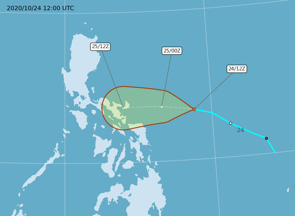
| current | 14:36, 24 October 2020 | | 956 × 700 (108 KB) | Cewbot (talk | contribs) | Import CWB tropical cyclone forecast map of Northwest Pacific tropical depression TD21: Position 241200Z at 13.3N 128.8E, Movement: W 25km/hr. Minimum pressure 1002 hpa, Max sustained winds near center 15 meter per second, Gusts 23 meter per second. https://www.cwb.gov.tw/Data/typhoon/TY_NEWS/Download_PTA_202010241200_TD21_enus.png (2020-10-24 12:00 UTC) |
| 08:35, 24 October 2020 |  | 956 × 700 (106 KB) | Cewbot (talk | contribs) | Import CWB tropical cyclone forecast map of Northwest Pacific tropical depression TD21: Position 240600Z at 13.0N 130.0E, Movement: W 17km/hr. Minimum pressure 1002 hpa, Max sustained winds near center 15 meter per second, Gusts 23 meter per second. https://www.cwb.gov.tw/Data/typhoon/TY_NEWS/Download_PTA_202010240600_TD21_enus.png (2020-10-24 06:00 UTC) | |
| 02:35, 24 October 2020 |  | 956 × 700 (103 KB) | Cewbot (talk | contribs) | Import CWB tropical cyclone forecast map of Northwest Pacific tropical depression TD21: Position 240000Z at 12.2N 131.2E, Movement: WNW 21km/hr. Minimum pressure 1002 hpa, Max sustained winds near center 15 meter per second, Gusts 23 meter per second. https://www.cwb.gov.tw/Data/typhoon/TY_NEWS/Download_PTA_202010240000_TD21_enus.png (2020-10-24 00:00 UTC) | |
| 20:34, 23 October 2020 |  | 956 × 700 (103 KB) | Cewbot (talk | contribs) | Import CWB tropical cyclone forecast map of Northwest Pacific tropical depression TD21: Position 231800Z at 11.5N 132.5E, Movement: NW 21km/hr. Minimum pressure 1004 hpa, Max sustained winds near center 12 meter per second, Gusts 20 meter per second. https://www.cwb.gov.tw/Data/typhoon/TY_NEWS/Download_PTA_202010231800_TD21_enus.png (2020-10-23 18:00 UTC) | |
| 13:34, 23 October 2020 |  | 956 × 700 (94 KB) | Cewbot (talk | contribs) | Import CWB tropical cyclone forecast map of Northwest Pacific tropical depression TD21: Position 231200Z at 11.0N 133.5E, Movement: NW 18km/hr. Minimum pressure 1004 hpa, Max sustained winds near center 12 meter per second, Gusts 20 meter per second. https://www.cwb.gov.tw/Data/typhoon/TY_NEWS/Download_PTA_202010231200_TD21_enus.png (2020-10-23 12:00 UTC) | |
| 08:36, 23 October 2020 |  | 956 × 700 (84 KB) | Cewbot (talk | contribs) | Import CWB tropical cyclone forecast map of Northwest Pacific tropical depression TD21: Position 230600Z at 10.0N 134.0E, Movement: NNW 19km/hr. Minimum pressure 1004 hpa, Max sustained winds near center 12 meter per second, Gusts 20 meter per second. https://www.cwb.gov.tw/Data/typhoon/TY_NEWS/Download_PTA_202010230600_TD21_enus.png (2020-10-23 06:00 UTC) |
You cannot overwrite this file.
File usage on Commons
The following page uses this file:
.png&oldid=899044399)