File:2020 CWB Haishen forecast map (en-US).png
Jump to navigation
Jump to search
Size of this preview: 800 × 586 pixels. Other resolutions: 320 × 234 pixels | 640 × 469 pixels | 956 × 700 pixels.
Original file (956 × 700 pixels, file size: 97 KB, MIME type: image/png)
Captions
Captions
Add a one-line explanation of what this file represents
Summary
[edit]| Description |
|
| Date | |
| Source | https://www.cwb.gov.tw/Data/typhoon/TY_NEWS/Download_PTA_202009040600_HAISHEN_enus.png |
| Author | Central Weather Administration |
| Other versions |
Traditional Chinese: .png) |

.png&action=edit§ion=1)
Licensing
[edit].png&action=edit§ion=2)

|
The copyright holder of this file, Central Weather Administration, allows anyone to use it for any purpose, provided that the copyright holder is properly attributed. Redistribution, derivative work, commercial use, and all other use is permitted. |
Attribution:
|
|
|
This file is licensed under the Government Website Open Information Announcement.
Information on Related Items:
|
 |
|
|
File history
Click on a date/time to view the file as it appeared at that time.
.png&dir=prev)
.png&offset=20200905133432)
.png&offset=&limit=20)
.png&offset=&limit=50)
.png&offset=&limit=100)
.png&offset=&limit=250)
.png&offset=&limit=500)
| Date/Time | Thumbnail | Dimensions | User | Comment | |
|---|---|---|---|---|---|
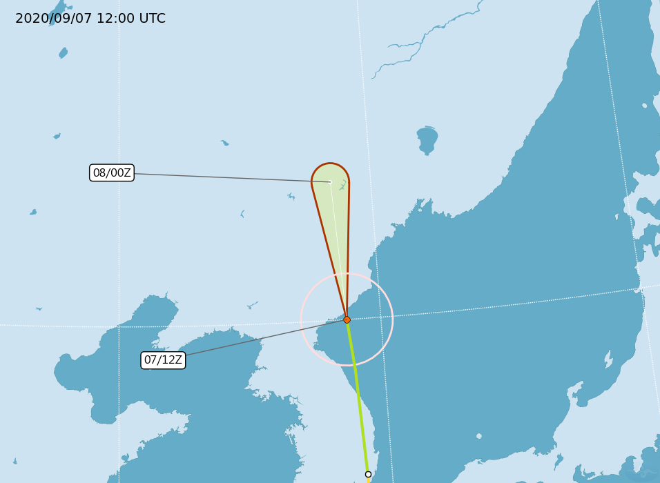
| current | 13:35, 7 September 2020 | | 956 × 700 (97 KB) | Cewbot (talk | contribs) | Import CWB tropical cyclone forecast map of Northwest Pacific severe tropical storm Haishen: Position 071200z at four zero point zero zero north (40.0N) one two eight point seven zero east (128.7E), Movement: N 37km/hr. Minimum pressure 980 hpa, Max sustained winds near center 28 meter per second, Gusts 35 meter per second, Radius of over 15m/s winds 150km. https://www.cwb.gov.tw/Data/typhoon/TY_NEWS/Download_PTA_202009071200_HAISHEN_enus.png (2020-09-07 12:00 UTC) |
| 07:34, 7 September 2020 |  | 956 × 700 (106 KB) | Cewbot (talk | contribs) | Import CWB tropical cyclone forecast map of Northwest Pacific severe tropical storm Haishen: Position 070600z at three eight point five zero north (38.5N) one two eight point nine zero east (128.9E), Movement: N 40km/hr. Minimum pressure 970 hpa, Max sustained winds near center 30 meter per second, Gusts 38 meter per second, Radius of over 15m/s winds 180km, Radius of over 25m/s winds 50km. https://www.cwb.gov.tw/Data/typhoon/TY_NEWS/Download_PTA_202009070600_HA... | |
| 01:34, 7 September 2020 |  | 956 × 700 (138 KB) | Cewbot (talk | contribs) | Import CWB tropical cyclone forecast map of Northwest Pacific typhoon Haishen: Position 070000z at three five point four zero north (35.4N) one two nine point one zero east (129.1E), Movement: N 43km/hr. Minimum pressure 965 hpa, Max sustained winds near center 35 meter per second, Gusts 45 meter per second, Radius of over 15m/s winds 200km, Radius of over 25m/s winds 65km. https://www.cwb.gov.tw/Data/typhoon/TY_NEWS/Download_PTA_202009070000_HAISHEN_enus.png (2... | |
| 20:34, 6 September 2020 |  | 956 × 700 (140 KB) | Cewbot (talk | contribs) | Import CWB tropical cyclone forecast map of Northwest Pacific typhoon Haishen: Position 061800z at three three point two zero north (33.2N) one two nine point one zero east (129.1E), Movement: N 45km/hr. Minimum pressure 945 hpa, Max sustained winds near center 43 meter per second, Gusts 53 meter per second, Radius of over 15m/s winds 280km, Radius of over 25m/s winds 90km. https://www.cwb.gov.tw/Data/typhoon/TY_NEWS/Download_PTA_202009061800_HAISHEN_enus.png (2... | |
| 14:34, 6 September 2020 |  | 956 × 700 (143 KB) | Cewbot (talk | contribs) | Import CWB tropical cyclone forecast map of Northwest Pacific typhoon Haishen: Position 061200z at three one point one zero north (31.1N) one two nine point four zero east (129.4E), Movement: N 39km/hr. Minimum pressure 945 hpa, Max sustained winds near center 43 meter per second, Gusts 53 meter per second, Radius of over 15m/s winds 280km, Radius of over 25m/s winds 90km. https://www.cwb.gov.tw/Data/typhoon/TY_NEWS/Download_PTA_202009061200_HAISHEN_enus.png (20... | |
| 07:34, 6 September 2020 |  | 956 × 700 (143 KB) | Cewbot (talk | contribs) | Import CWB tropical cyclone forecast map of Northwest Pacific typhoon Haishen: Position 060600z at two nine point three zero north (29.3N) one three zero point one zero east (130.1E), Movement: NNW 33km/hr. Minimum pressure 940 hpa, Max sustained winds near center 45 meter per second, Gusts 55 meter per second, Radius of over 15m/s winds 300km, Radius of over 25m/s winds 100km. https://www.cwb.gov.tw/Data/typhoon/TY_NEWS/Download_PTA_202009060600_HAISHEN_enus.pn... | |
| 02:35, 6 September 2020 |  | 956 × 700 (163 KB) | Cewbot (talk | contribs) | Import CWB tropical cyclone forecast map of Northwest Pacific typhoon Haishen: Position 060000z at two seven point six zero north (27.6N) one three zero point six zero east (130.6E), Movement: NNW 32km/hr. Minimum pressure 930 hpa, Max sustained winds near center 48 meter per second, Gusts 58 meter per second, Radius of over 15m/s winds 300km, Radius of over 25m/s winds 100km. https://www.cwb.gov.tw/Data/typhoon/TY_NEWS/Download_PTA_202009060000_HAISHEN_enus.png... | |
| 01:35, 6 September 2020 |  | 956 × 700 (169 KB) | Cewbot (talk | contribs) | Import CWB tropical cyclone forecast map of Northwest Pacific typhoon Haishen: Position 060000z at two seven point six zero north (27.6N) one three zero point six zero east (130.6E), Movement: NNW 32km/hr. Minimum pressure 930 hpa, Max sustained winds near center 48 meter per second, Gusts 58 meter per second, Radius of over 15m/s winds 300km, Radius of over 25m/s winds 100km. https://www.cwb.gov.tw/Data/typhoon/TY_NEWS/Download_PTA_202009060000_HAISHEN_enus.png... | |
| 20:34, 5 September 2020 |  | 956 × 700 (167 KB) | Cewbot (talk | contribs) | Import CWB tropical cyclone forecast map of Northwest Pacific typhoon Haishen: Position 051800z at two six point four zero north (26.4N) one three zero point nine zero east (130.9E), Movement: NNW 26km/hr. Minimum pressure 925 hpa, Max sustained winds near center 51 meter per second, Gusts 63 meter per second, Radius of over 15m/s winds 300km, Radius of over 25m/s winds 120km. https://www.cwb.gov.tw/Data/typhoon/TY_NEWS/Download_PTA_202009051800_HAISHEN_enus.png... | |
| 13:34, 5 September 2020 |  | 956 × 700 (166 KB) | Cewbot (talk | contribs) | Import CWB tropical cyclone forecast map of Northwest Pacific typhoon Haishen: Position 051200z at two five point five zero north (25.5N) one three one point zero zero east (131.0E), Movement: NNW 19km/hr. Minimum pressure 920 hpa, Max sustained winds near center 53 meter per second, Gusts 65 meter per second, Radius of over 15m/s winds 300km, Radius of over 25m/s winds 120km. https://www.cwb.gov.tw/Data/typhoon/TY_NEWS/Download_PTA_202009051200_HAISHEN_enus.png... |
You cannot overwrite this file.
File usage on Commons
The following page uses this file:
.png&oldid=899044361)