File:2020-08-23 104349 Bad Münder Süntel Monument Belgian Air Component.jpg
![File:2020-08-23 104349 Bad Münder Süntel Monument Belgian Air Component.jpg](https://upload.wikimedia.org/wikipedia/commons/thumb/8/85/2020-08-23_104349_Bad_M%C3%BCnder_S%C3%BCntel_Monument_Belgian_Air_Component.jpg/800px-2020-08-23_104349_Bad_M%C3%BCnder_S%C3%BCntel_Monument_Belgian_Air_Component.jpg?20201229222920)
Original file (7,296 × 3,648 pixels, file size: 21.21 MB, MIME type: image/jpeg)
Captions
Captions
Summary
[edit]Description2020-08-23 104349 Bad Münder Süntel Monument Belgian Air Component.jpg |
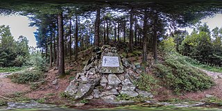
Deutsch: Kugelpanorama vom Gedenkstein im Süntel für zwei verunglückte Angehörige der Belgian Air Component
Inschrift: Hier fanden am 16.10.1962 |
||||||||||||||||
Date | |||||||||||||||||
Source | Own work | ||||||||||||||||
Author |
creator QS:P170,Q84847593 |
Camera location | 52° 10′ 36.22″ N, 9° 22′ 52″ E ![]() | View this and other nearby images on: OpenStreetMap | ![]() |
---|
360°2020-08-23 104349 Bad Münder Süntel Monument Belgian Air Component.jpg | View in 360° panoramic viewer
|
---|
Licensing
[edit]![w:en:Creative Commons](https://upload.wikimedia.org/wikipedia/commons/thumb/7/79/CC_some_rights_reserved.svg/90px-CC_some_rights_reserved.svg.png)
![attribution](https://upload.wikimedia.org/wikipedia/commons/thumb/1/11/Cc-by_new_white.svg/24px-Cc-by_new_white.svg.png)
![share alike](https://upload.wikimedia.org/wikipedia/commons/thumb/d/df/Cc-sa_white.svg/24px-Cc-sa_white.svg.png)
- You are free:
- to share – to copy, distribute and transmit the work
- to remix – to adapt the work
- Under the following conditions:
- attribution – You must give appropriate credit, provide a link to the license, and indicate if changes were made. You may do so in any reasonable manner, but not in any way that suggests the licensor endorses you or your use.
- share alike – If you remix, transform, or build upon the material, you must distribute your contributions under the same or compatible license as the original.
File history
Click on a date/time to view the file as it appeared at that time.
Date/Time | Thumbnail | Dimensions | User | Comment | |
---|---|---|---|---|---|
current | 22:29, 29 December 2020 | ![]() | 7,296 × 3,648 (21.21 MB) | Tim Rademacher (talk | contribs) | Uploaded own work with UploadWizard |
You cannot overwrite this file.
File usage on Commons
There are no pages that use this file.
Metadata
This file contains additional information such as Exif metadata which may have been added by the digital camera, scanner, or software program used to create or digitize it. If the file has been modified from its original state, some details such as the timestamp may not fully reflect those of the original file. The timestamp is only as accurate as the clock in the camera, and it may be completely wrong.
Camera manufacturer | RICOH |
---|---|
Camera model | RICOH THETA Z1 |
Author | Tim Rademacher |
Copyright holder | Tim Rademacher (Q84847593) |
Exposure time | 1/13 sec (0.076923076923077) |
F-number | f/5.6 |
ISO speed rating | 200 |
Date and time of data generation | 10:43, 23 August 2020 |
Lens focal length | 2.6 mm |
User comments | Monument Belgian Air Component im Süntel |
Latitude | 52° 10′ 36.22″ N |
Longitude | 9° 22′ 52″ E |
Altitude | 459.59 meters above sea level |
Location depicted | Gedenkstein Belgian Air Componentl |
City shown | Bad Münder |
Horizontal resolution | 1 dpc |
Vertical resolution | 1 dpc |
Software used | RICOH THETA Z1 Ver 1.50.1 |
File change date and time | 10:43, 23 August 2020 |
Y and C positioning | Centered |
Exposure Program | Aperture priority |
Exif version | 2.32 |
Date and time of digitizing | 10:43, 23 August 2020 |
Meaning of each component |
|
APEX shutter speed | 3.7004397215097 |
APEX aperture | 4.9708536585366 |
APEX brightness | 3.68 |
APEX exposure bias | 0 |
Maximum land aperture | 2.1407786609188 APEX (f/2.1) |
Metering mode | Pattern |
Light source | Unknown |
Supported Flashpix version | 1 |
Color space | Uncalibrated |
GPS time (atomic clock) | 08:43 |
Geodetic survey data used | WGS-84 |
GPS date | 23 August 2020 |
GPS tag version | 2.2.0.0 |
Flash | Flash did not fire |
Bits per component | 8 |
Height | 3,648 px |
Width | 7,296 px |
capturesoftware | THETA Z1 |
Panorama cropped height | 3,648 |
Panorama cropped width | 7,296 |
Panorama left crop | 0 |
Panorama top crop | 0 |
Panorama full height | 3,648 |
Panorama full width | 7,296 |
Initial FOV (horizontal degrees) | 75.0 |
Projection type | Equirectangular |
Use panorama viewer | Yes |
Sublocation of city shown | Gedenkstein Belgian Air Componen |
Province or state shown | Niedersachsen |
Country shown | Deutschland |
IIM version | 4 |