File:20191021130DR Karsdorf (Rabenau) INFO Zipfelheide.jpg
Jump to navigation
Jump to search

Size of this preview: 397 × 600 pixels. Other resolutions: 159 × 240 pixels | 318 × 480 pixels | 508 × 768 pixels | 678 × 1,024 pixels | 2,218 × 3,351 pixels.
Original file (2,218 × 3,351 pixels, file size: 5.31 MB, MIME type: image/jpeg)
Captions
Captions
Add a one-line explanation of what this file represents
Summary
[edit]| Description |
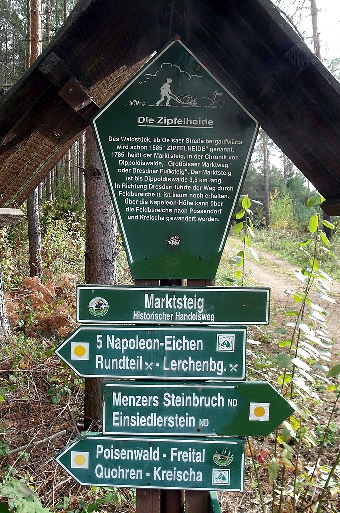
Deutsch: 21.10.2019 01734 Karsdorf (Rabenau): An der Wegkreuzung von Schulsteig und Marktsteig in der Zipfelheide (dem nördlichen Teil der Dippoldiswalder Heide) steht dieser Wegweiser mit Info-Tafel (GMP: 50.940840,13.684495). Das Waldstück ab Oelsaer Straße bergaufwärts wurde schon 1585 "ZIPFELHEIDE" genannt. 1785 heißt der Marktsteig, in der Chronik von Dippoldiswalde, "Großölsaer Marktweg" oder "Dresdner Fußsteig". Der Marktsteig ist bis Dippoldiswalde 3,5 km lang. In Richtung Dresden führte der Weg durch Feldbereiche und ist kaum noch erhalten. Über die Napoleons-Höhe kann über die Feldbereiche nach Possendorf und Kreischa gewandert werden. [SAM1507.JPG]20191021130DR.JPG(c)Blobelt |
||||||||||||||
| Date | |||||||||||||||
| Source | Own work | ||||||||||||||
| Author |
|
||||||||||||||

_INFO_Zipfelheide.jpg&action=edit§ion=1)
| Object location | | View this and other nearby images on: OpenStreetMap |
|---|
_INFO_Zipfelheide.jpg¶ms=050.940840_N_0013.684495_E_globe:Earth_class:object_type:object__&language=en)
Licensing
[edit]_INFO_Zipfelheide.jpg&action=edit§ion=2)
This file is licensed under the Creative Commons Attribution-Share Alike 4.0 International license.
- You are free:
- to share – to copy, distribute and transmit the work
- to remix – to adapt the work
- Under the following conditions:
- attribution – You must give appropriate credit, provide a link to the license, and indicate if changes were made. You may do so in any reasonable manner, but not in any way that suggests the licensor endorses you or your use.
- share alike – If you remix, transform, or build upon the material, you must distribute your contributions under the same or compatible license as the original.
File history
Click on a date/time to view the file as it appeared at that time.
| Date/Time | Thumbnail | Dimensions | User | Comment | |
|---|---|---|---|---|---|
| current | 19:55, 22 October 2019 | | 2,218 × 3,351 (5.31 MB) | Jörg Blobelt (talk | contribs) | User created page with UploadWizard |
You cannot overwrite this file.
File usage on Commons
There are no pages that use this file.
_INFO_Zipfelheide.jpg&oldid=758395895)