File:2019-10-31 13-48-56 Tupungato.jpg
Jump to navigation
Jump to search

Size of this preview: 800 × 533 pixels. Other resolutions: 320 × 213 pixels | 640 × 427 pixels | 1,024 × 683 pixels | 1,280 × 853 pixels | 2,560 × 1,707 pixels | 3,648 × 2,432 pixels.
Original file (3,648 × 2,432 pixels, file size: 2.66 MB, MIME type: image/jpeg)
Captions
Captions
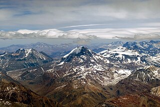
The Tupungato (6550 m a.s.l., distance 57 km) in the center with the Tupungatito on the right. To the left Cerro Negro (Co. Pabellón de Sta. Clara) with the valley of the Río Tupungato in between.
Summary
[edit]
| Description |
Deutsch: Flughöhe ca. 8500 m ü.M., in etwa über Punta de Vacas (2400 m ü.M., Argentinien). Der Tupungato (6550 m ü.M., Entfernung 57 km) in der Mitte mit dem Tupungatito zu seiner Rechten. Links davon der Cerro Negro (Co. Pabellón de Sta. Clara) mit dem Tal des Río Tupungato dazwischen. Der Vulkan Maipo (5264 m ü.M, Entfernung 145 km) am Horizont hinter dem Tupungatito. Der Marmolejo, Kegel am rechten Rand der bis in die Wolken reicht.
Español: Altitud de vuelo 8500 m s.n.m. aprox., casi encima de Punta de Vacas (2400 m s.n.m., Argentina). El Tupungato (6550 m s.n.m., distancia 57 km) en el centro con el Tupungatito a su derecha. A su izquierda el Cerro Negro (Co. Pabellón de Sta. Clara) y el valle del Río Tupungato de por medio. El Volcán Maipo (5264 m s.n.m., distancia 145 km) en el horizonte detrás del Tupungatito. El Marmolejo, cono al borde derecho que llega hasta las nubes.
English: Flight altitud about 8500 m a.s.l., approximately over Punta de Vacas (2400 m a.s.l., Argentina). The Tupungato (6550 m a.s.l., distance 57 km) in the center with the Tupungatito on the right. To the left Cerro Negro (Co. Pabellón de Sta. Clara) with the valley of the Río Tupungato in between. The volcano Maipo (5264 m a.s.l., distance 145 km) on the horizon behind the Tupungatito. The Marmolejo, cone near the right edge that reaches into the clouds. |
| Date | 31 October 2019, 13:48:56 (according to Exif data) |
| Source | Own work |
| Author | WeHaKa |
| Permission (Reusing this file) |
This file is licensed under the Creative Commons Attribution-Share Alike 4.0 International license. Attribution: WeHaKa
|
| Camera location | | View this and other nearby images on: OpenStreetMap |
|---|
| Object location | | View this and other nearby images on: OpenStreetMap |
|---|
| Annotations | This image is annotated: View the annotations at Commons |
File history
Click on a date/time to view the file as it appeared at that time.
| Date/Time | Thumbnail | Dimensions | User | Comment | |
|---|---|---|---|---|---|
| current | 16:23, 15 December 2019 | | 3,648 × 2,432 (2.66 MB) | WeHaKa (talk | contribs) | {{Information |description = {{de| Flughöhe ca. 8500 m ü.M., in etwa über Punta de Vacas (2400 m ü.M., Argentinien). Der Tupungato (6550 m ü.M., Entfernung 57 km) in der Mitte mit dem Tupungatito zu seiner Rechten. Links davon der Cerro Negro (Co. Pabellón de Sta. Clara) mit dem Tal des Río Tupungato dazwischen. Der Vulkan Maipo (5264 m ü.M, Entfernung 145 km) am Horizont hinter dem Tupungatito. Der Marmolejo, Kegel am rechten Rand der bis in die Wolken reicht. }} {{es| Altitud de vuel... |
You cannot overwrite this file.
File usage on Commons
The following page uses this file: