File:2018 Oklahoma gubernatorial election results map by county.svg
Jump to navigation
Jump to search

Size of this PNG preview of this SVG file: 800 × 399 pixels. Other resolutions: 320 × 160 pixels | 640 × 319 pixels | 1,024 × 511 pixels | 1,280 × 638 pixels | 2,560 × 1,277 pixels | 810 × 404 pixels.
Original file (SVG file, nominally 810 × 404 pixels, file size: 37 KB)
Captions
Captions
Add a one-line explanation of what this file represents
Summary
[edit]| Description |
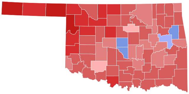
English: 2018 Oklahoma gubernatorial election by county.
Kevin Stitt >= 40%
Stitt >= 50%
Stitt >= 60%
Stitt >= 70%
Stitt >= 80%
Drew Edmondson >= 40%
Edmondson >= 50% |
| Date | |
| Source | Modified version of File:Oklahoma county map, cb_500k.svg (public domain) |
| Author |
|
| SVG development |

Licensing
[edit]
| I, the copyright holder of this work, release this work into the public domain. This applies worldwide. In some countries this may not be legally possible; if so: I grant anyone the right to use this work for any purpose, without any conditions, unless such conditions are required by law. |
File history
Click on a date/time to view the file as it appeared at that time.
| Date/Time | Thumbnail | Dimensions | User | Comment | |
|---|---|---|---|---|---|
| current | 15:22, 24 December 2023 | | 810 × 404 (37 KB) | Putitonamap98 (talk | contribs) | shapes |
| 22:42, 13 August 2022 |  | 744 × 378 (265 KB) | Kingofthedead (talk | contribs) | Reverted to version as of 06:15, 13 May 2022 (UTC) Consensus has changed to use accurate borders | |
| 18:21, 13 May 2022 |  | 320 × 168 (47 KB) | Putitonamap98 (talk | contribs) | Reverted to version as of 20:22, 31 March 2022 (UTC) | |
| 06:15, 13 May 2022 |  | 744 × 378 (265 KB) | Kingofthedead (talk | contribs) | Reverted to version as of 12:00, 21 January 2022 (UTC) | |
| 20:22, 31 March 2022 |  | 320 × 168 (47 KB) | Putitonamap98 (talk | contribs) | Reverted to version as of 10:14, 14 February 2019 (UTC) Reverting until we reach a consensus about map styles | |
| 12:00, 21 January 2022 |  | 744 × 378 (265 KB) | Master of Time (talk | contribs) | Higher quality shapes | |
| 10:14, 14 February 2019 |  | 320 × 168 (47 KB) | Master of Time (talk | contribs) | Fix Greer | |
| 02:36, 13 November 2018 |  | 320 × 168 (47 KB) | Master of Time (talk | contribs) | {{Information |description={{en|1={{w|United States gubernatorial elections, 2018|2018 US gubernatorial elections}} in {{w|Oklahoma}} by county. {{legend|#ffb2b2|2={{w|Kevin Stitt}} >= 40%}} {{legend|#e27f7f|2=Stitt >= 50%}} {{legend|#d75d5d|2=Stitt >= 60%}} {{legend|#d72f30|2=Stitt >= 70%}} {{legend|#c21b18|2=Stitt >= 80%}} {{legend|#a5b0ff|2={{w|Drew Edmondson}} >= 40%}} {{legend|#7996e2|2=Edmondson >= 50%}} }} |date=2018-11-12 |source=Modified version of [[:File:Oklahoma Election Results b... |
You cannot overwrite this file.
File usage on Commons
The following 10 pages use this file:
- User:Magog the Ogre/Political maps/2018 November 11-20
- User:Magog the Ogre/Political maps/2019 February 10-18
- User:Magog the Ogre/Political maps/2022 August 11-20
- User:Magog the Ogre/Political maps/2022 January 21-31
- User:Magog the Ogre/Political maps/2022 March 21-31
- User:Magog the Ogre/Political maps/2022 May 11-20
- User:Magog the Ogre/Political maps/2023 December 21-31
- File:Oklahoma Governor Election Results by County, 2018.svg (file redirect)
File usage on other wikis
The following other wikis use this file:
- Usage on en.wikipedia.org