File:2018-P02-Friesland.jpg
Jump to navigation
Jump to search

Size of this preview: 733 × 600 pixels. Other resolutions: 293 × 240 pixels | 587 × 480 pixels | 939 × 768 pixels | 1,252 × 1,024 pixels | 2,503 × 2,048 pixels | 2,914 × 2,384 pixels.
Original file (2,914 × 2,384 pixels, file size: 1,010 KB, MIME type: image/jpeg)
Captions
Captions
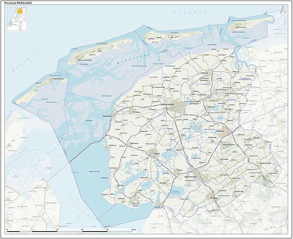
Topological map of Friesland, a province of the Netherlands. Compiled by Jan-Willem van Aalst using Dutch Governmental open data (CC-BY Kadaster) and OpenStreetMap data (CC-BY OpenStreetMap contributors).
Summary
[edit]
| Description |
English: Toographic overview map of the Dutch Province of Friesland as of 2018. Compiled by Jan-Willem van Aalst using Dutch Governmental open data (CC-BY Kadaster) and OpenStreetMap data (CC-BY OpenStreetMap contributors).
Nederlands: Topografische overzichtskaart van de Nederlandse provincie Friesland per 2018. Kaartbeeld samengesteld door Jan-Willem van Aalst uit Nederlandse open overheidsdata (CC-BY Kadaster) en OpenStreetMap data (CC-BY OpenStreetMap bijdragers). |
| Date | |
| Source | Own work |
| Author | Janwillemvanaalst |
Licensing
[edit]
I, the copyright holder of this work, hereby publish it under the following license:
This file is licensed under the Creative Commons Attribution-Share Alike 4.0 International license.
- You are free:
- to share – to copy, distribute and transmit the work
- to remix – to adapt the work
- Under the following conditions:
- attribution – You must give appropriate credit, provide a link to the license, and indicate if changes were made. You may do so in any reasonable manner, but not in any way that suggests the licensor endorses you or your use.
- share alike – If you remix, transform, or build upon the material, you must distribute your contributions under the same or compatible license as the original.
File history
Click on a date/time to view the file as it appeared at that time.
| Date/Time | Thumbnail | Dimensions | User | Comment | |
|---|---|---|---|---|---|
| current | 13:14, 31 December 2017 | | 2,914 × 2,384 (1,010 KB) | Janwillemvanaalst (talk | contribs) | User created page with UploadWizard |
You cannot overwrite this file.
File usage on Commons
The following 3 pages use this file:
_route.jpg)
_route.jpg)
File usage on other wikis
The following other wikis use this file:
- Usage on ar.wikipedia.org
- Usage on ast.wikipedia.org
- Usage on cv.wikipedia.org
- Usage on da.wikipedia.org
- Usage on de.wikipedia.org
- Usage on en.wikipedia.org
- Usage on eo.wikipedia.org
- Usage on es.wikipedia.org
- Usage on fi.wikipedia.org
- Usage on fo.wikipedia.org
- Usage on fy.wikipedia.org
- Ketlik
- Reduzum
- Wommels
- Hurdegaryp
- Grou (plak)
- Dokkum
- Drylts
- Starum
- Warkum
- Mildaam
- Raerd
- Jirnsum
- Nijskoat
- Wergea
- Bantegea
- Surhústerfean
- De Westereen
- Sibrandahûs (Dantumadiel)
- Frjentsjer
- Hegebeintum
- Harstastate
- Akkrum
- De Jouwer
- Noardwâlde (Weststellingwerf)
- Abbegea
- Feanwâlden
- Sleat (stêd)
- Jislum
- Friens
- Beslingastate
- Dearsum (Súdwest-Fryslân)
- Eagum
- Ferwert
- Ginnum
- Bueren (It Amelân)
- Nes (It Hearrenfean)
- Hylpen
- Penjum
- Driezum
View more global usage of this file.