File:2018-01-19-1742UTC A 48hrsfc.gif
Jump to navigation
Jump to search

Size of this preview: 800 × 509 pixels. Other resolutions: 320 × 204 pixels | 640 × 407 pixels | 1,200 × 764 pixels.
Original file (1,200 × 764 pixels, file size: 300 KB, MIME type: image/gif)
Captions
Captions
Add a one-line explanation of what this file represents
Summary
[edit]
| Description |
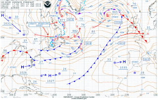
English: 48h Atlantic surface forecast map, issued January 19, 2018 at 17:42 UTC, valid January 21, 2018 at 18:00 UTC
Deutsch: 48-Stunden-Oberflächenprognose für den Nordatlantik, ausgegeben am 19. Januar 2018 um 17:42 Uhr UTC, gültig für den 21. Januar 2018 um 18:00 Uhr UTC. |
| Date | |
| Source | http://www.opc.ncep.noaa.gov/shtml/A_48hrsfc.gif |
| Author | Ocean Prediction Center NOAA |
Licensing
[edit]
This image is in the public domain because it contains materials that originally came from the U.S. National Oceanic and Atmospheric Administration, taken or made as part of an employee's official duties.
|
File history
Click on a date/time to view the file as it appeared at that time.
| Date/Time | Thumbnail | Dimensions | User | Comment | |
|---|---|---|---|---|---|
| current | 22:23, 19 January 2018 | | 1,200 × 764 (300 KB) | Matthiasb (talk | contribs) | {{Information |Description ={{en|1=48h Atlantic surface analysis map, issued January 19, 2018 at 17:42 UTC, valid January 21, 2018 at 18:00 UTC}} {{de|1=48-Stunden-Oberflächenanalyse für den Nordatlantik, ausgegeben am 19. Januar 2018 um 17:42 Uhr... |
You cannot overwrite this file.
File usage on Commons
There are no pages that use this file.