File:20150602150DR Olbernhau von der Kretzschmarhöhe.jpg
Jump to navigation
Jump to search

Size of this preview: 800 × 441 pixels. Other resolutions: 320 × 176 pixels | 640 × 353 pixels | 1,024 × 564 pixels | 1,280 × 705 pixels | 3,264 × 1,799 pixels.
Original file (3,264 × 1,799 pixels, file size: 3.58 MB, MIME type: image/jpeg)
Captions
Captions
Add a one-line explanation of what this file represents
Summary
[edit]| Description |
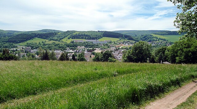
Deutsch: 02.06.2015 09526 Olbernhau: Blick von der Saydaer Straße / Kretzschmarhöhe nach Süden über Olbernhau. Leicht links der Bildmitte, etwas erhöht, das dreiteilige Bahnhofsgebäude (GMP: 50.656557,13.336800) von Olbernhau. Die Stadtkirche ist verdeckt. Olbernhau entstand aus einer deutschen Ostsiedlung. 1346 wurde es zum ersten mal urkundlich erwähnt, 1434 als Albernhaw bezeichnet. Olbernhau gehörte zur Herrschaft Lauterstein und wurde 1599 im Zuge des Ankaufs der Herrschaft durch Kurfürst August I. zum Amtsdorf. Von 1699 - 1759 war der Ort Sitz des Amtes Lauterstein. In dieser Zeit begann man auch mit der Anlage des Marktplatzes, der in seiner Geschlossenheit als städtebauliches Ensemble des 18. Jahrhunderts zum Denkmalschutzgebiet erklärt wurde. Olbernhau, das um 1800 als Marktflecken bezeichnet und erst 1902 zur Stadt erklärt wurde, erstreckt sich heute mit seinen Stadtteilen über eine Entfernung von etwa 13 km, meist längs der Flöha. Der Fluß fließt von links nach rechts mittige im Bild durch die Stadt, ist aber von den Häusern verdeckt. [SAM0621.JPG]20150602150DR.JPG(c)Blobelt |
||||||||||||||
| Date | |||||||||||||||
| Source | Own work | ||||||||||||||
| Author |
|
||||||||||||||

| Object location | | View this and other nearby images on: OpenStreetMap |
|---|
Licensing
[edit]
This file is licensed under the Creative Commons Attribution-Share Alike 4.0 International license.
- You are free:
- to share – to copy, distribute and transmit the work
- to remix – to adapt the work
- Under the following conditions:
- attribution – You must give appropriate credit, provide a link to the license, and indicate if changes were made. You may do so in any reasonable manner, but not in any way that suggests the licensor endorses you or your use.
- share alike – If you remix, transform, or build upon the material, you must distribute your contributions under the same or compatible license as the original.
File history
Click on a date/time to view the file as it appeared at that time.
| Date/Time | Thumbnail | Dimensions | User | Comment | |
|---|---|---|---|---|---|
| current | 20:04, 22 September 2023 | | 3,264 × 1,799 (3.58 MB) | Jörg Blobelt (talk | contribs) | Uploaded a work by {{Creator:Jörg Blobelt}} from {{own}} with UploadWizard |
You cannot overwrite this file.
File usage on Commons
The following page uses this file: