File:2014 North American polar vortex NOAA map ua nhem 500p.png
Jump to navigation
Jump to search
Size of this preview: 571 × 600 pixels. Other resolutions: 229 × 240 pixels | 457 × 480 pixels | 700 × 735 pixels.
Original file (700 × 735 pixels, file size: 51 KB, MIME type: image/png)
Captions
Captions
Add a one-line explanation of what this file represents
Summary
[edit]
| Description |
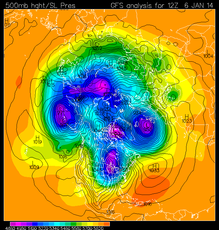
English: The jet stream for January 6, 2014 (pale blue in map to right) follows a wavy pattern over the whole Northern hemisphere, and the path of the jet stream is out of the north over the central U.S., bringing cold air southward from the Arctic and producing record cold temperatures for the eastern half of the U.S.. Regions of light blue color show the counter-clockwise path of the jet stream for January 6, 2014. The map in white near the bottom center shows the outline of the U.S. |
| Date | |
| Source | http://www.pmel.noaa.gov/arctic/atmosphere/polar_vortex_2014.html |
| Author | National Oceanic and Atmospheric Administration - Pacific Marine Environmental Laboratory |
Licensing
[edit]
This image is in the public domain because it contains materials that originally came from the U.S. National Oceanic and Atmospheric Administration, taken or made as part of an employee's official duties.
|
File history
Click on a date/time to view the file as it appeared at that time.
| Date/Time | Thumbnail | Dimensions | User | Comment | |
|---|---|---|---|---|---|
| current | 14:33, 7 January 2014 | | 700 × 735 (51 KB) | Oaktree b (talk | contribs) | User created page with UploadWizard |
You cannot overwrite this file.
File usage on Commons
There are no pages that use this file.
File usage on other wikis
The following other wikis use this file:
- Usage on es.wikipedia.org