File:20140917 Oude Aa (Drentsche Aa) Gn NL.jpg
From Wikimedia Commons, the free media repository
Jump to navigation
Jump to search
![File:20140917 Oude Aa (Drentsche Aa) Gn NL.jpg](https://upload.wikimedia.org/wikipedia/commons/thumb/0/0c/20140917_Oude_Aa_%28Drentsche_Aa%29_Gn_NL.jpg/800px-20140917_Oude_Aa_%28Drentsche_Aa%29_Gn_NL.jpg?20170201191337)
Size of this preview: 800 × 600 pixels. Other resolutions: 320 × 240 pixels | 640 × 480 pixels | 1,024 × 768 pixels | 1,280 × 960 pixels | 2,560 × 1,920 pixels | 4,000 × 3,000 pixels.
Original file (4,000 × 3,000 pixels, file size: 8.21 MB, MIME type: image/jpeg)
File information
Structured data
Captions
Captions
Add a one-line explanation of what this file represents
Description20140917 Oude Aa (Drentsche Aa) Gn NL.jpg |
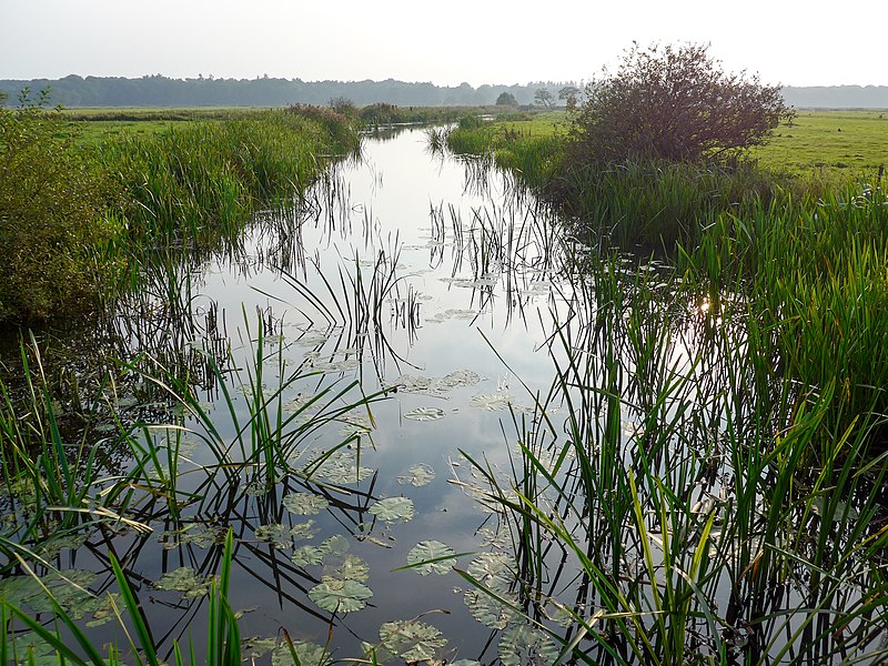
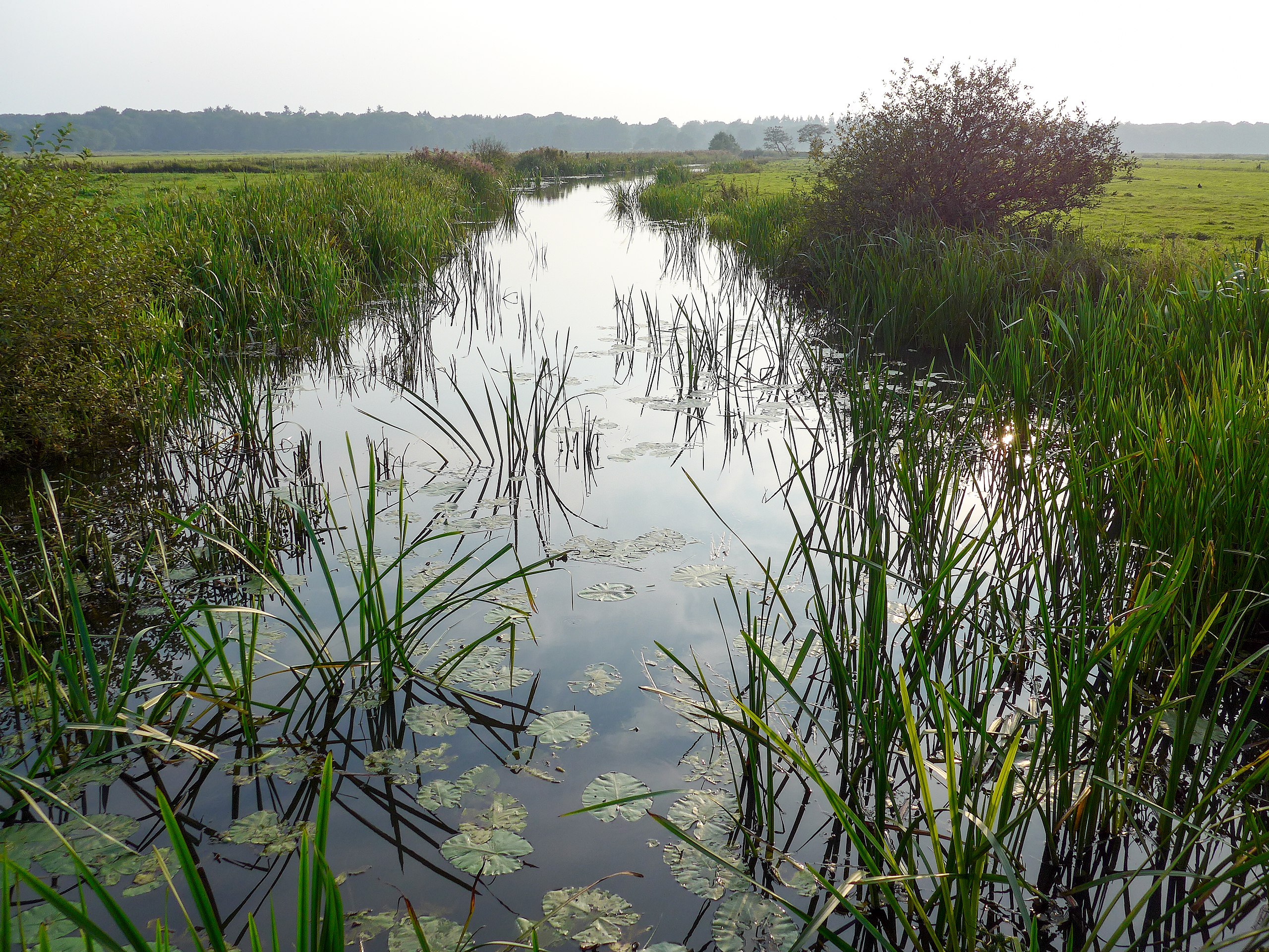
English: De Oude Aa, a part of the Drentsche Aa, a river in the Dutch provinces of Drenthe and Groningen. Frysk: De Oude Aa (in part fan de Drentsche Aa), sjoen fan de Hooidijk by Oosterbroek wei. Dit part fan de Oude Aa leit krékt yn Grinslân. Nederlands: De Oude Aa (een deel van de Drentsche Aa), gezien vanaf de Hooidijk bij Oosterbroek. Dit gedeelte van de Oude Aa ligt nét in de provincie Groningen. |
Date | |
Source | Own work |
Author | |
Attribution (required by the license) InfoField | Wutsje / Wikimedia Commons / |
InfoField | Wutsje / Wikimedia Commons |
Permission (Reusing this file) |
![]() ![]() ![]() This file is licensed under the Creative Commons Attribution-Share Alike 4.0 International license.
|
Camera location | 53° 08′ 42.78″ N, 6° 36′ 03.61″ E ![]() ![]() | View this and other nearby images on: OpenStreetMap | ![]() |
---|
File history
Click on a date/time to view the file as it appeared at that time.
Date/Time | Thumbnail | Dimensions | User | Comment | |
---|---|---|---|---|---|
current | 19:13, 1 February 2017 | ![]() | 4,000 × 3,000 (8.21 MB) | Wutsje (talk | contribs) | {{Information |Description= {{Multilingual description |en=De ''Oude Aa'', a part of the ''Drentsche Aa'', a river in the Dutch provinces of Drenthe and Groningen. |fy=De ''Oude Aa'' (in part fan... |
You cannot overwrite this file.
File usage on Commons
There are no pages that use this file.
File usage on other wikis
The following other wikis use this file:
- Usage on nl.wikipedia.org
Metadata
This file contains additional information such as Exif metadata which may have been added by the digital camera, scanner, or software program used to create or digitize it. If the file has been modified from its original state, some details such as the timestamp may not fully reflect those of the original file. The timestamp is only as accurate as the clock in the camera, and it may be completely wrong.
Camera manufacturer | LEICA |
---|---|
Camera model | C (Typ 112) |
Exposure time | 1/800 sec (0.00125) |
F-number | f/2.8 |
ISO speed rating | 80 |
Date and time of data generation | 18:10, 16 September 2014 |
Lens focal length | 6 mm |
Image title | De Oude Aa (een deel van de Drentsche Aa), gezien vanaf de Hooidijk bij Oosterbroek, een buurtschap ten oosten van het Drentse Eelde. Dit deel van de Oude Aa ligt nét in de provincie Groningen. |
Author | Wutsje |
Credit/Provider | CC-BY-SA 4.0 - Wutsje |
Source | Own work |
Short title | De Oude Aa (Drentsche Aa) |
City shown | n/a |
Copyright holder | CC-BY-SA 4.0 - Wutsje |
JPEG file comment | CC-BY-SA 4.0 - Wutsje |
Horizontal resolution | 240 dpi |
Vertical resolution | 240 dpi |
Software used | Adobe Photoshop Lightroom 5.5 (Windows) |
File change date and time | 23:44, 17 September 2014 |
Exposure Program | Landscape mode (for landscape photos with the background in focus) |
Exif version | 2.3 |
Date and time of digitizing | 18:10, 16 September 2014 |
APEX shutter speed | 9.643856 |
APEX aperture | 2.970854 |
APEX exposure bias | 0 |
Maximum land aperture | 2 APEX (f/2) |
Metering mode | Pattern |
Light source | Unknown |
Flash | Flash did not fire, compulsory flash suppression |
Color space | sRGB |
Sensing method | One-chip color area sensor |
File source | Digital still camera |
Scene type | A directly photographed image |
Custom image processing | Normal process |
Exposure mode | Auto exposure |
White balance | Auto white balance |
Digital zoom ratio | 0 |
Focal length in 35 mm film | 29 mm |
Scene capture type | Standard |
Scene control | None |
Contrast | Normal |
Saturation | Normal |
Sharpness | Normal |
Date metadata was last modified | 01:44, 18 September 2014 |
Unique ID of original document | 92059788972FB298CBE74615ECF3B4E4 |
Sublocation of city shown | Hooidijk, bij Oosterbroek, Eelde |
Province or state shown | Groningen |
Country shown | Nederland / The Netherlands |
Keywords |
|
Structured data
Items portrayed in this file
depicts
17 September 2014
53°8'42.781"N, 6°36'3.611"E
image/jpeg
37072ad9c7e164d935092db6acc1335464101ea7
8,609,224 byte
3,000 pixel
4,000 pixel
Hidden categories: