File:20120408030MDR Oranienburg Schloß.jpg
From Wikimedia Commons, the free media repository
Jump to navigation
Jump to search

Size of this preview: 800 × 341 pixels. Other resolutions: 320 × 136 pixels | 640 × 273 pixels | 1,024 × 437 pixels | 1,280 × 546 pixels | 4,235 × 1,806 pixels.
Original file (4,235 × 1,806 pixels, file size: 6.15 MB, MIME type: image/jpeg)
File information
Structured data
Captions
Captions
Add a one-line explanation of what this file represents
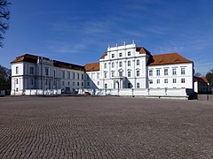
Schloß Oranienburg
Contents
Summary
Object
| Johann Gregor Memhardt: Oranienburg Palace
|
||||||||||||||||||||
|---|---|---|---|---|---|---|---|---|---|---|---|---|---|---|---|---|---|---|---|---|
| Architect |
|
|||||||||||||||||||
| Title |
Oranienburg Palace label QS:Les,"Palacio de Oranienburg"
label QS:Lsv,"Oranienburgs slott"
label QS:Luk,"Оранієнбург (палац)"
label QS:Lla,"Arausionis castrum"
label QS:Lru,"дворец Ораниенбург"
label QS:Lde,"Schloss Oranienburg"
label QS:Len,"Oranienburg Palace"
label QS:Lit,"castello di Oranienburg"
label QS:Lzh,"奥拉宁堡宫"
label QS:Lda,"Oranienburg Slot" |
|||||||||||||||||||
| Object type |
château |
|||||||||||||||||||
| Description |
Deutsch: 16515 Oranienburg, Schloßplatz 1: Schloß (GMP: 52.754860,13.236657). Ursprünglich mittelalterliche Wasserburg der Askanier. 1560 Jagdschloß Joachims II. Luise Henriette von Oranien plante hier einen Landsitz im holländischen Stil, der von 1651 bis 1655 entstand. Ab 1689 ließ der Sohn Louise Henriettes, Kurfürst Friedrich III., Schloß und Garten umbauen und vergrößern. In den Jahren 1858-60 erfolgte der Umbau zum Königlichen Lehrerseminar (bis 1925). Zwischen 1802 und 1851 wurde das Schloß gewerblich genutzt, danach ging es wieder in die Verwaltung der Königlichen Schlösser über. 1933-37 Kaserne der SS. 1937 entstand das noch heute vorhandene Haupttreppenhaus. Nach Kriegsschäden 1948 - 1954 äußerlich wiederhergestellt. Seit 1952, nach vorübergehender Nutzung durch die Rote Armee, war es bis 1990 Offiziersschule der Kasernierten Volkspolizei (KVP) und später Kaserne der Grenztruppen der DDR. 1997 wurde das Schloß der Stadt Oranienburg übertragen. Museale Nutzung. [DSCNn3670-3671.TIF]20120408030MDR.JPG(c)Blobelt |
|||||||||||||||||||
| Object location |
|
|||||||||||||||||||
| Authority file | ||||||||||||||||||||
| Other versions |
|
|||||||||||||||||||
Photograph
| Description20120408030MDR Oranienburg Schloß.jpg | |||||||||||||||
| Date | |||||||||||||||
| Source | Own work | ||||||||||||||
| Author |
creator QS:P170,Q28598952 |
||||||||||||||
| Object location | 52° 45′ 17.5″ N, 13° 14′ 11.97″ E | View this and other nearby images on: OpenStreetMap |
|---|
Licensing
This file is licensed under the Creative Commons Attribution-Share Alike 4.0 International license.
- You are free:
- to share – to copy, distribute and transmit the work
- to remix – to adapt the work
- Under the following conditions:
- attribution – You must give appropriate credit, provide a link to the license, and indicate if changes were made. You may do so in any reasonable manner, but not in any way that suggests the licensor endorses you or your use.
- share alike – If you remix, transform, or build upon the material, you must distribute your contributions under the same or compatible license as the original.
File history
Click on a date/time to view the file as it appeared at that time.
| Date/Time | Thumbnail | Dimensions | User | Comment | |
|---|---|---|---|---|---|
| current | 21:34, 8 March 2022 |  | 4,235 × 1,806 (6.15 MB) | Jörg Blobelt (talk | contribs) | Uploaded a work by {{Creator:Jörg Blobelt}} from {{own}} with UploadWizard |
You cannot overwrite this file.
File usage on Commons
The following page uses this file:
Metadata
This file contains additional information such as Exif metadata which may have been added by the digital camera, scanner, or software program used to create or digitize it. If the file has been modified from its original state, some details such as the timestamp may not fully reflect those of the original file. The timestamp is only as accurate as the clock in the camera, and it may be completely wrong.
| Image title | 08.04.2012 16515 Oranienburg, Schloßplatz 1: Schloß (GMP: 52.754860,13.236657). Ursprünglich mittelalterliche Wasserburg der Askanier. 1560 Jagdschloß Joachims II. Luise Henriette von Oranien plante hier einen Landsitz im holländischen Stil, der von 1651 bis 1655 entstand. Ab 1689 ließ der Sohn Louise Henriettes, Kurfürst Friedrich III., Schloß und Garten umbauen und vergrößern. In den Jahren 1858-60 erfolgte der Umbau zum Königlichen Lehrerseminar (bis 1925). Zwischen 1802 und 1851 wurde das Schloß gewerblich genutzt, danach ging es wieder in die Verwaltung der Königlichen Schlösser über. 1933-37 Kaserne der SS. 1937 entstand das noch heute vorhandene Haupttreppenhaus. Nach Kriegsschäden 1948 - 1954 äußerlich wiederhergestellt. Seit 1952, nach vorübergehender Nutzung durch die Rote Armee, war es bis 1990 Offiziersschule der Kasernierten Volkspolizei (KVP) und später Kaserne der Grenztruppen der DDR. 1997 wurde das Schloß der Stadt Oranienburg übertragen. Museale Nutzung. [DSCNn3670-3671.TIF]20120408030MDR.JPG(c)Blobelt |
|---|---|
| Copyright holder | Dr. Jörg Blobelt (retret 11.06.2015) |
| IIM version | 2 |


