File:2011 Tohoku tsunami height by Joint Research Group 2012-03-01.png
Jump to navigation
Jump to search

Size of this preview: 572 × 599 pixels. Other resolutions: 229 × 240 pixels | 458 × 480 pixels | 733 × 768 pixels | 1,050 × 1,100 pixels.
Original file (1,050 × 1,100 pixels, file size: 133 KB, MIME type: image/png)
Captions
Captions
Add a one-line explanation of what this file represents
Summary
[edit]
| Description |
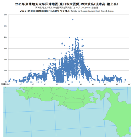
日本語:2011年w:ja:東北地方太平洋沖地震(w:ja:東日本大震災)による津波の緯度方向の高さの分布図。東北地方太平洋沖地震津波合同調査グループによる調査結果集計表(2012年3月1日公表分[1]に基づく。この表における「津波高」とは、痕跡高(浸水高)および遡上高を指す[2]。地図原図としてFile:Map of Japan.svgを用いた。) English: Researched tsunami heights sorted by latitude, 2011 Tohoku earthquake. Reserched by "Tohoku earthquake tsunami Joint Research Group"(東北地方太平洋沖地震津波合同調査グループ), on March 1, 2012. |
| Date | |
| Source | Own work |
| Author | Pekachu |
Licensing
[edit]
I, the copyright holder of this work, hereby publish it under the following license:
This file is licensed under the Creative Commons Attribution-Share Alike 3.0 Unported license.
- You are free:
- to share – to copy, distribute and transmit the work
- to remix – to adapt the work
- Under the following conditions:
- attribution – You must give appropriate credit, provide a link to the license, and indicate if changes were made. You may do so in any reasonable manner, but not in any way that suggests the licensor endorses you or your use.
- share alike – If you remix, transform, or build upon the material, you must distribute your contributions under the same or compatible license as the original.
File history
Click on a date/time to view the file as it appeared at that time.
| Date/Time | Thumbnail | Dimensions | User | Comment | |
|---|---|---|---|---|---|
| current | 09:14, 11 March 2012 | | 1,050 × 1,100 (133 KB) | Pekachu (talk | contribs) |
You cannot overwrite this file.
File usage on Commons
There are no pages that use this file.
File usage on other wikis
The following other wikis use this file:
- Usage on ga.wikipedia.org
- Usage on ja.wikipedia.org
- Usage on ko.wikipedia.org