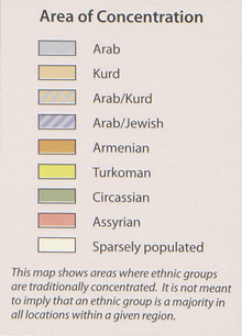
File:2011 Syria ethnoreligious distribution by the CIA (Armenians of Dayr az Zawr).png

Original file (890 × 503 pixels, file size: 848 KB, MIME type: image/png)
Captions
Captions
Summary
[edit]| Description2011 Syria ethnoreligious distribution by the CIA (Armenians of Dayr az Zawr).png |
English:  |
||||||
| Date | |||||||
| Source |
United States Library of Congress https://lccn.loc.gov/2012594227 http://hdl.loc.gov/loc.gmd/g7460.ct003606 https://www.loc.gov/item/2012594227/ |
||||||
| Author | United States Central Intelligence Agency | ||||||
| Other versions |
|
Licensing
[edit]| Public domainPublic domainfalsefalse |
| This image is a work of a Central Intelligence Agency employee, taken or made as part of that person's official duties. As a Work of the United States Government, this image or media is in the public domain in the United States.
čeština ∙ Deutsch ∙ eesti ∙ English ∙ español ∙ français ∙ italiano ∙ português ∙ polski ∙ sicilianu ∙ slovenščina ∙ suomi ∙ Tiếng Việt ∙ български ∙ македонски ∙ русский ∙ українська ∙ বাংলা ∙ മലയാളം ∙ 한국어 ∙ 日本語 ∙ 中文 ∙ 中文(简体) ∙ 中文(繁體) ∙ العربية ∙ پښتو ∙ +/− |

|
File history
Click on a date/time to view the file as it appeared at that time.
| Date/Time | Thumbnail | Dimensions | User | Comment | |
|---|---|---|---|---|---|
| current | 01:08, 9 August 2021 |  | 890 × 503 (848 KB) | GPinkerton (talk | contribs) | File:2011 Syria ethnoreligious distribution by the CIA.png cropped 55 % horizontally, 75 % vertically using CropTool with lossless mode. |
You cannot overwrite this file.
File usage on Commons
The following page uses this file:
Metadata
This file contains additional information such as Exif metadata which may have been added by the digital camera, scanner, or software program used to create or digitize it. If the file has been modified from its original state, some details such as the timestamp may not fully reflect those of the original file. The timestamp is only as accurate as the clock in the camera, and it may be completely wrong.
| Horizontal resolution | 118.11 dpc |
|---|---|
| Vertical resolution | 118.11 dpc |
| File change date and time | 00:48, 9 August 2021 |

