File:2011 Hurricane Katia off the Northeastern US Coastline.JPG
Jump to navigation
Jump to search

Size of this preview: 800 × 531 pixels. Other resolutions: 320 × 213 pixels | 640 × 425 pixels | 1,024 × 680 pixels | 1,280 × 850 pixels | 2,560 × 1,700 pixels | 4,288 × 2,848 pixels.
Original file (4,288 × 2,848 pixels, file size: 1.13 MB, MIME type: image/jpeg)
Captions
Captions
Add a one-line explanation of what this file represents
Licensing
[edit]
| Description |
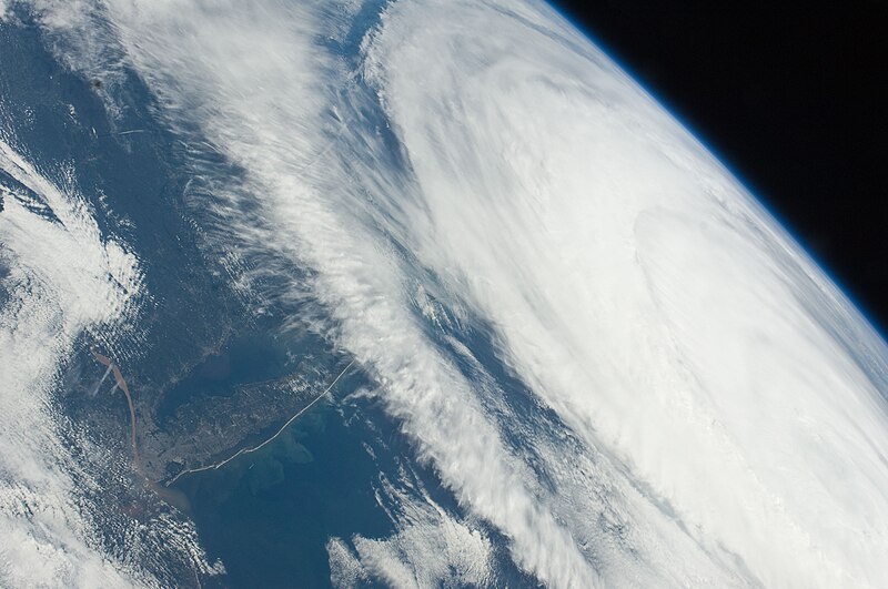
English: Hurricane Katia had diminished to Category 1 strength on the Saffir-Simpson scale by the time this astronaut photograph was taken, but it still presented an impressive cloud circulation as its centre passed the north-eastern coast of the United States. The approximate center of Hurricane Katia is visible at image right, with its outer cloud bands extending across the center of the view. A small part of New York—including Long Island and the Hudson River—is visible through a gap in the cloud cover. The Hudson River has a chocolate brown coloration due to heavy loading with sediment, a consequence of flooding and erosion of the upstream watershed by precipitation from Hurricane Irene and Tropical Storm Lee. A plume of sediment is visible entering the Atlantic Ocean on the southern coastline of Long Island, directly to the south of New York City (partially obscured by clouds). Crew members on the International Space Station can take images like this one by looking outwards at an angle through ISS windows—much like taking photographs of the ground from a commercial airliner window, albeit from an average altitude of 400 kilometres. |
| Date | |
| Source | NASA Earth Observatory |
| Author | ISS Expedition 28 crew |
| Camera location | | View this and other nearby images on: OpenStreetMap |
|---|
This image or video was catalogued by Johnson Space Center of the United States National Aeronautics and Space Administration (NASA) under Photo ID: ISS028-E-45516. This tag does not indicate the copyright status of the attached work. A normal copyright tag is still required. See Commons:Licensing. Other languages:
|
Image acquired with a Nikon D2Xs digital camera using a 28 mm lens, and is provided by the ISS Crew Earth Observations experiment and Image Science & Analysis Laboratory, Johnson Space Center.
Summary
[edit]
This file is in the public domain in the United States because it was created by the Image Science & Analysis Laboratory, of the NASA Johnson Space Center. NASA copyright policy states that "NASA material is not protected by copyright unless noted". (NASA media use guidelines or Conditions of Use of Astronaut Photographs).
Photo source: ISS028-E-45516.
|
| Annotations | This image is annotated: View the annotations at Commons |
File history
Click on a date/time to view the file as it appeared at that time.
| Date/Time | Thumbnail | Dimensions | User | Comment | |
|---|---|---|---|---|---|
| current | 08:59, 26 September 2011 | | 4,288 × 2,848 (1.13 MB) | Originalwana (talk | contribs) | {{Information |Description ={{en|1=Hurricane Katia had diminished to Category 1 strength on the Saffir-Simpson scale by the time this astronaut photograph was taken, but it still presented an impressive cloud circulation as its centre passed the no |
You cannot overwrite this file.
File usage on Commons
The following page uses this file:
- File:ISS028-E-45516 - View of Massachusetts.jpg (file redirect)