File:2011 Dimos Vorias Kynourias.png
Jump to navigation
Jump to search

Size of this preview: 581 × 600 pixels. Other resolutions: 233 × 240 pixels | 465 × 480 pixels | 1,000 × 1,032 pixels.
Original file (1,000 × 1,032 pixels, file size: 183 KB, MIME type: image/png)
Captions
Captions
Add a one-line explanation of what this file represents
Summary
[edit]
| Description |
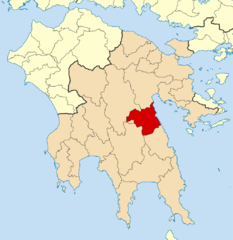
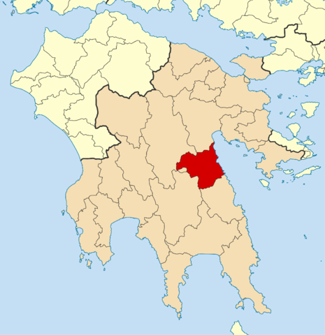
English: Locator map for Voria Kynouria municipality in Greek region Peloponnese (2011)
Deutsch: Lage der Gemeinde Voria Kynouria in der griechischen Region Peloponnes (2011) |
| Date | |
| Source | Own work |
| Author | Pitichinaccio |
Licensing
[edit]
I, the copyright holder of this work, hereby publish it under the following licenses:

|
Permission is granted to copy, distribute and/or modify this document under the terms of the GNU Free Documentation License, Version 1.2 or any later version published by the Free Software Foundation; with no Invariant Sections, no Front-Cover Texts, and no Back-Cover Texts. A copy of the license is included in the section entitled GNU Free Documentation License. |
This file is licensed under the Creative Commons Attribution 3.0 Unported license.
- You are free:
- to share – to copy, distribute and transmit the work
- to remix – to adapt the work
- Under the following conditions:
- attribution – You must give appropriate credit, provide a link to the license, and indicate if changes were made. You may do so in any reasonable manner, but not in any way that suggests the licensor endorses you or your use.
You may select the license of your choice.
File history
Click on a date/time to view the file as it appeared at that time.
| Date/Time | Thumbnail | Dimensions | User | Comment | |
|---|---|---|---|---|---|
| current | 10:22, 6 November 2010 | | 1,000 × 1,032 (183 KB) | Pitichinaccio (talk | contribs) | == Summary == {{Information |Description={{en|1=Locator map for Voria Kynouria municipality in Greek region Peloponnese (2011)}} {{de|1=Lage der Gemeinde Voria Kynouria in der griechischen Region Peloponnes (2011)}} |Source={{own}} |Author=[[User:Pitichin |
You cannot overwrite this file.
File usage on Commons
There are no pages that use this file.
File usage on other wikis
The following other wikis use this file:
- Usage on ca.wikipedia.org
- Usage on ceb.wikipedia.org
- Usage on de.wikipedia.org
- Usage on el.wikipedia.org
- Άστρος
- Νομός Αρκαδίας
- Έλατος Αρκαδίας
- Βέρβενα
- Κούτρουφα Αρκαδίας
- Δήμος Βόρειας Κυνουρίας
- Κυνουρία
- Καστάνιτσα Αρκαδίας
- Κορακοβούνι Αρκαδίας
- Άνω Δολιανά Αρκαδίας
- Άγιος Ιωάννης Αρκαδίας
- Αγία Αναστασία Αρκαδίας
- Πλάτανος Αρκαδίας
- Κάτω Δολιανά Αρκαδίας
- Πρότυπο:Δήμος Βόρειας Κυνουρίας
- Στόλος Αρκαδίας
- Ξηροπήγαδο Αρκαδίας
- Χρήστης:Geraki/Δήμοι
- Πραστός Αρκαδίας
- Σίταινα Αρκαδίας
- Άγιος Πέτρος Αρκαδίας
- Μονή Λουκούς Αρκαδίας
- Μονή Μαλεβής Αρκαδίας
- Καστρί Αρκαδίας
- Μονή Αρτοκωστάς Αρκαδίας
- Μονή Τιμίου Προδρόμου Αρκαδίας
- Ωριά Αρκαδίας
- Μεσορράχη Αρκαδίας
- Νέα Χώρα Αρκαδίας
- Πλατάνα Αρκαδίας
- Χάραδρος Αρκαδίας
- Αρκαδικό Χωριό
- Του Καράτουλα Αρκαδίας
- Περδικόβρυση Αρκαδίας
- Άγιος Γεώργιος Αρκαδίας
- Αγία Σοφία Αρκαδίας
- Ορεινή Μελιγού Αρκαδίας
- Κάτω Βέρβενα Αρκαδίας
- Χειμερινή Μελιγού Αρκαδίας
- Άγιος Ανδρέας Αρκαδίας
- Ορεινό Κορακοβούνι Αρκαδίας
- Καμινάρι Αρκαδίας
- Παράλιο Άστρος
- Παραλία Αγίου Ανδρέα Αρκαδίας
View more global usage of this file.