File:2011-R02-Fryslan-b54.jpg
Jump to navigation
Jump to search
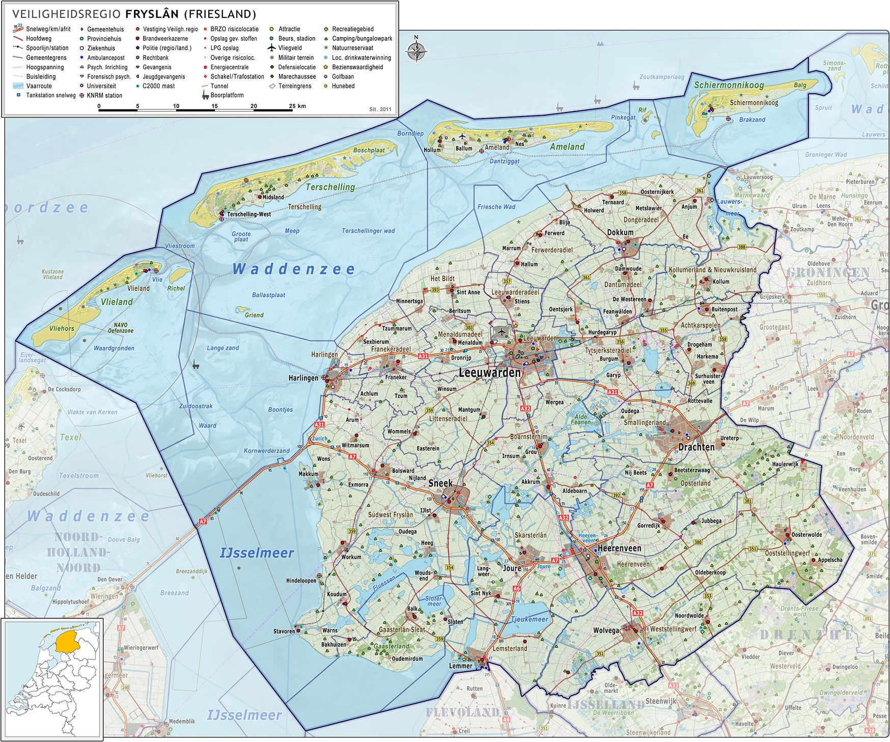
Size of this preview: 719 × 599 pixels. Other resolutions: 288 × 240 pixels | 576 × 480 pixels | 921 × 768 pixels | 1,229 × 1,024 pixels | 1,748 × 1,457 pixels.
Original file (1,748 × 1,457 pixels, file size: 1.3 MB, MIME type: image/jpeg)
Captions
Captions
Add a one-line explanation of what this file represents
Summary
[edit]
| Description |
Nederlands: Veiligheidsregio Fryslân (Friesland), met indeling van gemeenten (2011) en impressie van het landschap.
Door Jan-Willem van Aalst, samengesteld uit publiek beschikbare geo-data:
|
| Date | |
| Source | Own work |
| Author | Janwillemvanaalst |
| Other versions | 2010-R02-Fryslan-basisbeeld.jpg |
Licensing
[edit]
I, the copyright holder of this work, hereby publish it under the following license:
This file is licensed under the Creative Commons Attribution-Share Alike 3.0 Unported license.
- You are free:
- to share – to copy, distribute and transmit the work
- to remix – to adapt the work
- Under the following conditions:
- attribution – You must give appropriate credit, provide a link to the license, and indicate if changes were made. You may do so in any reasonable manner, but not in any way that suggests the licensor endorses you or your use.
- share alike – If you remix, transform, or build upon the material, you must distribute your contributions under the same or compatible license as the original.
File history
Click on a date/time to view the file as it appeared at that time.
| Date/Time | Thumbnail | Dimensions | User | Comment | |
|---|---|---|---|---|---|
| current | 09:07, 19 June 2011 | | 1,748 × 1,457 (1.3 MB) | Janwillemvanaalst (talk | contribs) | Added water life rescue (KNRM) locations; update of Defense/Military locations including KMAR |
| 05:59, 5 June 2011 |  | 1,722 × 1,410 (1.21 MB) | Janwillemvanaalst (talk | contribs) | Added various village names; complete update of hazardous locations, including many terrain borders; added highway distance denominators; | |
| 07:09, 15 May 2011 |  | 1,669 × 1,366 (1.13 MB) | Janwillemvanaalst (talk | contribs) | Revision of sea and coastline; updated infrastructure (local roads) and points of interest (fire brigade locations, ambulance locations) | |
| 16:27, 3 May 2011 |  | 1,669 × 1,366 (1.13 MB) | Janwillemvanaalst (talk | contribs) | Corrected various points of interest; updated fire dept. locations; added some area around the regional border (by request) | |
| 17:08, 9 March 2011 |  | 1,541 × 1,268 (976 KB) | Janwillemvanaalst (talk | contribs) | Added public health services; added regional road labels (N-roads); corrected various ambulance service points | |
| 19:16, 23 February 2011 |  | 1,541 × 1,268 (750 KB) | Janwillemvanaalst (talk | contribs) | Added local airports; Added Golf courses; Added major city parks. | |
| 17:28, 13 February 2011 |  | 1,541 × 1,268 (963 KB) | Janwillemvanaalst (talk | contribs) | Reported mistakes/issues corrected. Added various points of interest. | |
| 11:38, 31 December 2010 |  | 1,460 × 1,166 (811 KB) | Janwillemvanaalst (talk | contribs) | {{Information |Description={{nl|1=Veiligheidsregio Fryslân (Friesland), met indeling van gemeenten (2011) en impressie van het landschap. Door Jan-Willem van Aalst, samengesteld uit publiek beschikbare geo-data: * Referentie-ondergrond (kustlijn, steden, |
You cannot overwrite this file.
File usage on Commons
There are no pages that use this file.
File usage on other wikis
The following other wikis use this file:
- Usage on fy.wikipedia.org