File:2011-07-06 07-08 Kanada, Ontario 056 Kitchener, City Hall (6067176058) (cropped).jpg
From Wikimedia Commons, the free media repository
Jump to navigation
Jump to search
Size of this preview: 798 × 114 pixels. Other resolutions: 320 × 46 pixels | 640 × 91 pixels | 1,024 × 146 pixels | 5,536 × 791 pixels.
Original file (5,536 × 791 pixels, file size: 3.13 MB, MIME type: image/jpeg)
File information
Structured data
Captions
Summary
[edit]Description2011-07-06 07-08 Kanada, Ontario 056 Kitchener, City Hall (6067176058) (cropped).jpg |
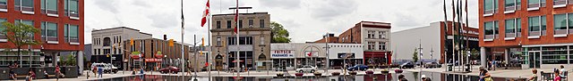
English: Carl Zehr Square in Kitchener, Ontario, Canada. In the background are shops on the opposite side of King Street West. |
|||
Date | ||||
Source | 2011-07-06 07-08 Kanada, Ontario 056 Kitchener, City Hall | |||
Author | Allie_Caulfield from Germany | |||
Other versions |
|
Camera location | 43° 27′ 04.8″ N, 80° 29′ 34.24″ W | View this and other nearby images on: OpenStreetMap | 43.451333; -80.492845 |
---|
Licensing
[edit]This file is licensed under the Creative Commons Attribution 2.0 Generic license.
- You are free:
- to share – to copy, distribute and transmit the work
- to remix – to adapt the work
- Under the following conditions:
- attribution – You must give appropriate credit, provide a link to the license, and indicate if changes were made. You may do so in any reasonable manner, but not in any way that suggests the licensor endorses you or your use.
File history
Click on a date/time to view the file as it appeared at that time.
Date/Time | Thumbnail | Dimensions | User | Comment | |
---|---|---|---|---|---|
current | 19:46, 23 October 2019 | 5,536 × 791 (3.13 MB) | Traveler100 (talk | contribs) | File:2011-07-06 07-08 Kanada, Ontario 056 Kitchener, City Hall (6067176058).jpg cropped 63 % vertically using CropTool with precise mode. |
You cannot overwrite this file.
File usage on Commons
The following page uses this file:
File usage on other wikis
The following other wikis use this file:
Metadata
This file contains additional information such as Exif metadata which may have been added by the digital camera, scanner, or software program used to create or digitize it. If the file has been modified from its original state, some details such as the timestamp may not fully reflect those of the original file. The timestamp is only as accurate as the clock in the camera, and it may be completely wrong.
Image title |
|
---|---|
Camera manufacturer | SONY |
Camera model | SLT-A55V |
Exposure time | 1/200 sec (0.005) |
F-number | f/10 |
ISO speed rating | 100 |
Date and time of data generation | 17:46, 7 July 2011 |
Lens focal length | 16 mm |
Latitude | 43° 27′ 4.8″ N |
Longitude | 80° 29′ 34.24″ W |
Altitude | 386.2 meters above sea level |
Orientation | Normal |
Horizontal resolution | 350 dpi |
Vertical resolution | 350 dpi |
Software used | Adobe Photoshop Elements 6.0 Windows |
File change date and time | 13:21, 21 August 2011 |
Y and C positioning | Co-sited |
Exposure Program | Normal program |
Exif version | 2.3 |
Date and time of digitizing | 17:46, 7 July 2011 |
Meaning of each component |
|
Image compression mode | 3 |
APEX brightness | 10.12 |
APEX exposure bias | 0 |
Maximum land aperture | 3.61 APEX (f/3.49) |
Metering mode | Pattern |
Light source | Cloudy weather |
Flash | Flash did not fire, compulsory flash suppression |
Supported Flashpix version | 1 |
Color space | sRGB |
File source | Digital still camera |
Scene type | A directly photographed image |
Custom image processing | Normal process |
Exposure mode | Auto exposure |
White balance | Manual white balance |
Focal length in 35 mm film | 24 mm |
Scene capture type | Standard |
Contrast | Normal |
Saturation | Normal |
Sharpness | Normal |
GPS time (atomic clock) | 16:42 |
Receiver status | Measurement interoperability |
Measurement mode | 3-dimensional measurement |
Speed unit | Kilometers per hour |
Speed of GPS receiver | 0.5 |
Reference for direction of movement | True direction |
Direction of movement | 49.76 |
Geodetic survey data used | WGS-84 |
GPS date | 7 July 2011 |
GPS differential correction | 0 |
GPS tag version | 0.0.3.2 |
Supported Flashpix version | 1 |
Image width | 5,536 px |
Image height | 2,160 px |
Date metadata was last modified | 06:21, 21 August 2011 |