File:2010 Japan Census population prefectures.svg
Jump to navigation
Jump to search

Size of this PNG preview of this SVG file: 496 × 599 pixels. Other resolutions: 199 × 240 pixels | 397 × 480 pixels | 635 × 768 pixels | 847 × 1,024 pixels | 1,695 × 2,048 pixels | 1,200 × 1,450 pixels.
Original file (SVG file, nominally 1,200 × 1,450 pixels, file size: 47 KB)
Captions
Captions
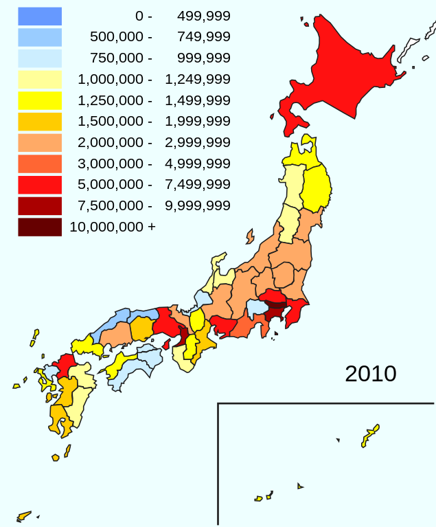
Population classification map of Japan by prefectures in 2010
Summary
[edit]
| Description |
日本語:2010年国勢調査における都道府県別人口地図。 |
| Date | |
| Source | Map:Japan_template_large.svg |
| Author | Monaneko(Japan_template_large.svg), modified by Pekachu (talk) |
Licensing
[edit]
This file is licensed under the Creative Commons Attribution-Share Alike 4.0 International license.
- You are free:
- to share – to copy, distribute and transmit the work
- to remix – to adapt the work
- Under the following conditions:
- attribution – You must give appropriate credit, provide a link to the license, and indicate if changes were made. You may do so in any reasonable manner, but not in any way that suggests the licensor endorses you or your use.
- share alike – If you remix, transform, or build upon the material, you must distribute your contributions under the same or compatible license as the original.
File history
Click on a date/time to view the file as it appeared at that time.
| Date/Time | Thumbnail | Dimensions | User | Comment | |
|---|---|---|---|---|---|
| current | 09:11, 25 April 2023 | | 1,200 × 1,450 (47 KB) | Peka (talk | contribs) | change classification, colors |
| 12:07, 24 April 2015 |  | 1,400 × 1,600 (42 KB) | Pekachu (talk | contribs) | User created page with UploadWizard |
You cannot overwrite this file.
File usage on Commons
The following page uses this file: