File:2010 Haiti Earthquake (After).jpg
Jump to navigation
Jump to search
Size of this preview: 600 × 600 pixels. Other resolutions: 240 × 240 pixels | 480 × 480 pixels | 768 × 768 pixels | 1,024 × 1,024 pixels | 2,048 × 2,048 pixels | 2,992 × 2,992 pixels.
Original file (2,992 × 2,992 pixels, file size: 14.29 MB, MIME type: image/jpeg)
Captions
Captions
Add a one-line explanation of what this file represents
Summary
[edit].jpg&action=edit§ion=1)
| Description |
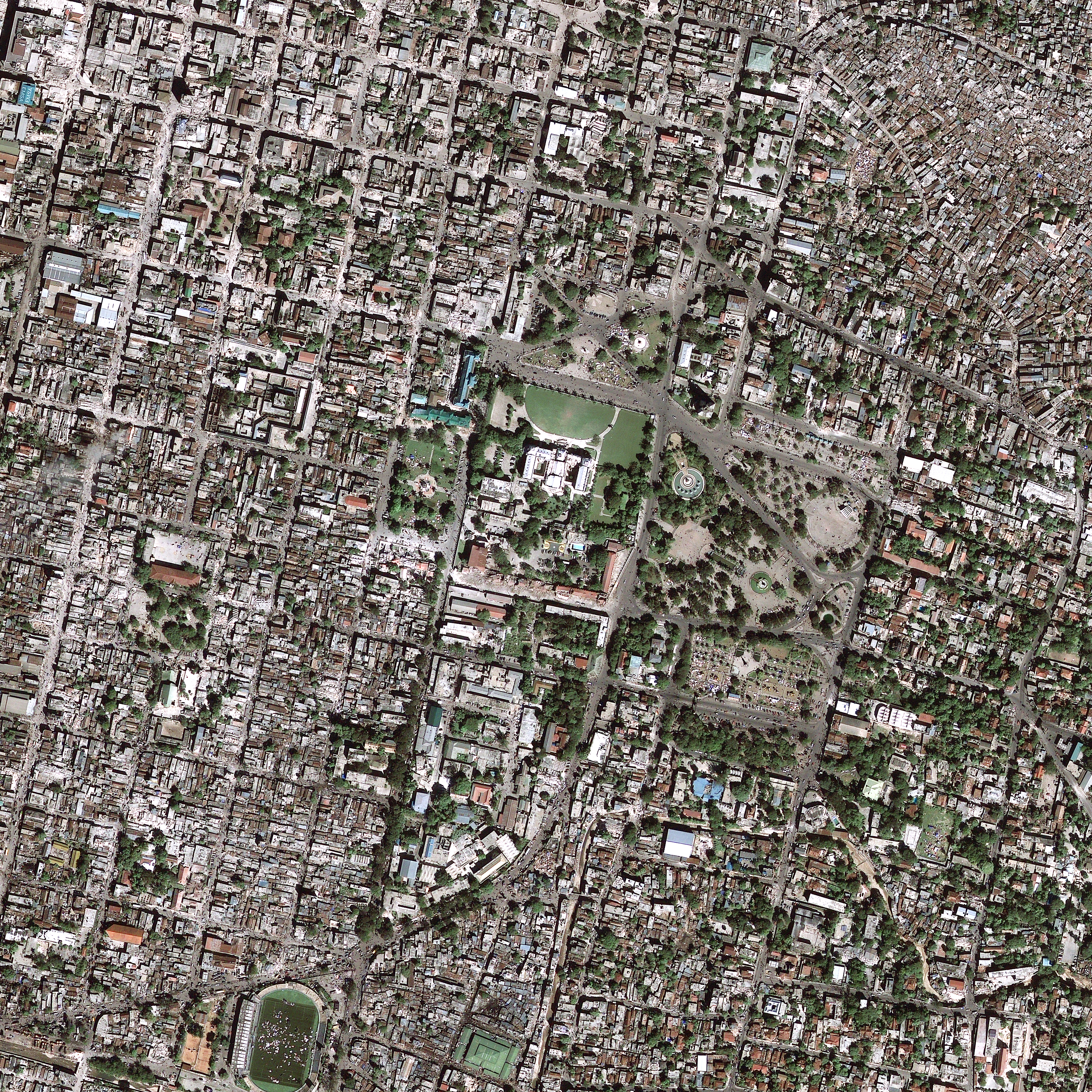
English: 2010 Haiti Earthquake — Five years ago, today, Haiti experienced a devastating M7.0 earthquake. The January 12, 2010, Haiti earthquake occurred in the boundary region separating the Caribbean plate and the North America plate. This plate boundary is dominated by left-lateral strike slip motion and compression, and accommodates about 20 mm/y slip, with the Caribbean plate moving eastward with respect to the North America plate.
This photo is a high resolution satellite image showing the landscape and building damages after the earthquake hit Haiti. This image is part of the USGS Hazard Data Distribution System, which acquires and delivers satellite and aerial imagery in near-real time during natural or human-caused disasters. View the high resolution images below (wait a few seconds once the page loads and you should be able to zoom around the image by moving your mouse over the image). Haiti Before: on.doi.gov/HaitiBefore Haiti After: on.doi.gov/HaitiAfter |
| Date | |
| Source | https://www.flickr.com/photos/27784370@N05/15641193744/ |
| Author | U.S. Geological Survey |
Licensing
[edit].jpg&action=edit§ion=2)
| This file is made available under the Creative Commons CC0 1.0 Universal Public Domain Dedication. | |
| The person who associated a work with this deed has dedicated the work to the public domain by waiving all of their rights to the work worldwide under copyright law, including all related and neighboring rights, to the extent allowed by law. You can copy, modify, distribute and perform the work, even for commercial purposes, all without asking permission.
|
| This image was originally posted to Flickr by U.S. Geological Survey at https://flickr.com/photos/27784370@N05/15641193744. It was reviewed on 19 January 2022 by FlickreviewR 2 and was confirmed to be licensed under the terms of the cc-zero. |
File history
Click on a date/time to view the file as it appeared at that time.
| Date/Time | Thumbnail | Dimensions | User | Comment | |
|---|---|---|---|---|---|
| current | 05:49, 19 January 2022 | | 2,992 × 2,992 (14.29 MB) | Ooligan (talk | contribs) | Uploaded a work by U.S. Geological Survey from https://www.flickr.com/photos/27784370@N05/15641193744/ with UploadWizard |
You cannot overwrite this file.
File usage on Commons
There are no pages that use this file.
.jpg&oldid=887806548)