File:2009 flu pandemic in the Philippines timeline.gif
Jump to navigation
Jump to search

Size of this preview: 384 × 599 pixels. Other resolutions: 154 × 240 pixels | 308 × 480 pixels | 492 × 768 pixels | 656 × 1,024 pixels | 2,000 × 3,120 pixels.
Original file (2,000 × 3,120 pixels, file size: 583 KB, MIME type: image/gif, looped, 7 frames, 0.1 s)
Captions
Captions
Add a one-line explanation of what this file represents
| Description |
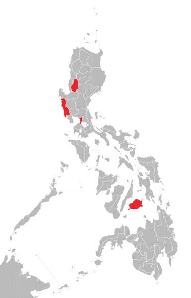
English: Map of the Philippines showing the cases of A(H1N1) flu virus. Tagalog: Mapa ng Pilipinas na nagpakita ng mga kaso ng A(H1N1) flu virus. Cebuano: Mapa sa Pilipinas nga nagpakita sa mga kaso sa A(H1N1) flu virus. English: Colors shown: Black - deaths Dark red -confirmed cases followed by community outbreaks Red - confirmed cases Yellow- suspected cases Tagalog: Nagpakitang mga kulay: Itim - may namatay Madilim na pula - community outbreak Pula - konpirmadong kaso Dilaw - suspetsadong kaso |
| Date | (UTC) |
| Source | |
| Author |
|
| This is a retouched picture, which means that it has been digitally altered from its original version. Modifications: GIF version. The original can be viewed here: Ph AH1N1 map.PNG:
|
I, the copyright holder of this work, hereby publish it under the following license:
| I, the copyright holder of this work, release this work into the public domain. This applies worldwide. In some countries this may not be legally possible; if so: I grant anyone the right to use this work for any purpose, without any conditions, unless such conditions are required by law. |
Original upload log
[edit]
This image is a derivative work of the following images:
- File:Ph_AH1N1_map.PNG licensed with PD-self
- 2009-06-22T12:36:04Z Tribu akru 2000x3120 (203660 Bytes) {{Information |Description={{en|1=Map of the Philippines showing the cases of A(H1N1) flu virus.}} {{tgl|1=Mapa ng Pilipinas na nagpakita ng mga kaso ng A(H1N1) flu virus.}} {{ceb|1=Mapa sa Pilipinas nga nagpakita sa mga kaso
Uploaded with derivativeFX
File history
Click on a date/time to view the file as it appeared at that time.
| Date/Time | Thumbnail | Dimensions | User | Comment | |
|---|---|---|---|---|---|
| current | 14:28, 23 June 2009 | | 2,000 × 3,120 (583 KB) | The Wandering Traveler (talk | contribs) | {{Information |Description={{en|1=Map of the Philippines showing the cases of A(H1N1) flu virus.}} {{tgl|1=Mapa ng Pilipinas na nagpakita ng mga kaso ng A(H1N1) flu virus.}} {{ceb|1=Mapa sa Pilipinas nga nagpakita sa mga kaso sa A(H1N1) flu virus.}} {{en| |
You cannot overwrite this file.
File usage on Commons
There are no pages that use this file.
File usage on other wikis
The following other wikis use this file:
- Usage on de.wikipedia.org
- Usage on tl.wikipedia.org