File:20090524 Buildings along Chicago River line the south border of the Near North Side and Streeterville and the north border of Chicago Loop, Lakeshore East and Illinois Center.jpg
Jump to navigation
Jump to search

Size of this preview: 800 × 287 pixels. Other resolutions: 320 × 115 pixels | 640 × 230 pixels | 1,024 × 367 pixels | 1,280 × 459 pixels | 2,560 × 918 pixels | 8,600 × 3,084 pixels.
Original file (8,600 × 3,084 pixels, file size: 9.28 MB, MIME type: image/jpeg)
Captions
Captions
Add a one-line explanation of what this file represents
Summary
[edit]| Description |
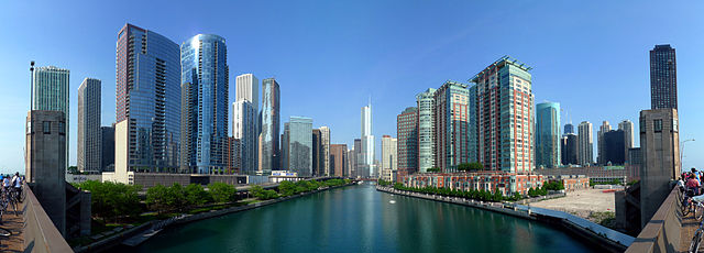
English: The Chicago River is the south border of the Near North Side and Streeterville and the north border of the New Eastside (viewed from Lake Shore Drive with Trump International Hotel and Tower at the jog in the river at the center. This 6-part composite panorama shows the optical center of the main branch of the Chicago River looking west (upstream) as seen from the upper vehicle deck of the Lake Shore Drive Bridge. The Trump Tower is at center (SOM), with Mies van der Rohe's 330 North Wabash slightly to the left of center. On the right bank is Streeterville, and the northern Loop is on the left. From left to right: The Parkshore, North Harbor Tower (both set back), The Chandler, The Regatta, The Tides, Aon Center (background), Aqua, Swissotel Chicago, Columbus Plaza, Hyatt Regency Chicago (west tower), One Illinois Center, Marina City, 330 North Wabash, Trump International Hotel & Tower Chicago, Sheraton Chicago Hotel & Towers, Cityfront Place, River View (west & east towers), Parkshore East, McClurg Court Center, John Hancock Center, 400 East Ohio, the Chicago Spire site, 401 East Ontario, Lake Shore Plaza, Onterie Center, North Pier Apartments |
| Date | |
| Source | https://www.flickr.com/photos/mindfrieze/3624597377/ |
| Author | flickr user mindfrieze |
| Other versions |


|
Licensing
[edit]
This file is licensed under the Creative Commons Attribution-Share Alike 2.0 Generic license.
- You are free:
- to share – to copy, distribute and transmit the work
- to remix – to adapt the work
- Under the following conditions:
- attribution – You must give appropriate credit, provide a link to the license, and indicate if changes were made. You may do so in any reasonable manner, but not in any way that suggests the licensor endorses you or your use.
- share alike – If you remix, transform, or build upon the material, you must distribute your contributions under the same or compatible license as the original.
| This image, originally posted to Flickr, was reviewed on 8 August 2009 by the administrator or reviewer Leoboudv, who confirmed that it was available on Flickr under the stated license on that date. |
File history
Click on a date/time to view the file as it appeared at that time.
| Date/Time | Thumbnail | Dimensions | User | Comment | |
|---|---|---|---|---|---|
| current | 02:10, 4 September 2010 | 8,600 × 3,084 (9.28 MB) | Mindfrieze (talk | contribs) | As the original author of this photo, I have recomposited this version from the original six photos to correct a slight tilt in the original composite. I also adjusted color levels and saturation slightly. Hugin 2009.4.0 and Gimp 2.6.8 were used. | |
| 13:20, 8 August 2009 | 8,613 × 3,301 (13.08 MB) | TonyTheTiger (talk | contribs) | {{Information |Description={{en|1=en:Chicago River is the south border of the Near North Side and en:Streeterville and the north border of en:Chicago Loop, en:Lakeshore East and en:Illinois Center |
You cannot overwrite this file.
File usage on Commons
The following 7 pages use this file:
- User:Sportsguy17
- User:Sportsguy17/sandbox2
- Commons:Featured picture candidates/File:20090524 Buildings along Chicago River line the south border of the Near North Side and Streeterville and the north border of Chicago Loop, Lakeshore East and Illinois Center.jpg
- Commons:Featured picture candidates/Log/March 2010
- Commons:Files used on the AARoads Wiki/1
- File:Riverwalk and Wacker Drive at Lakeshore East.jpg
- File:Riverwalk esplanade at River East.jpg
File usage on other wikis
The following other wikis use this file:
- Usage on ast.wikipedia.org
- Usage on cy.wikipedia.org
- Usage on en.wikipedia.org
- Chicago River
- Chicago Loop
- Talk:Chicago River
- Lake Shore Drive
- Streeterville
- Near North Side, Chicago
- Illinois Center
- Lakeshore East
- Wikipedia:WikiProject Chicago
- Wikipedia:Featured pictures/Places/Panorama
- Wikipedia:WikiProject Chicago/Featured articles
- Portal:United States/Selected panorama
- Wikipedia:Featured pictures thumbs/25
- Wikipedia:Featured picture candidates/Buildings along Chicago River
- Wikipedia:Featured picture candidates/September-2010
- Wikipedia:Wikipedia Signpost/2010-09-20/Features and admins
- User talk:TonyTheTiger/Archive 50
- Portal:United States/Selected panorama/32
- User:JeremyA/sandbox/Chicago River
- Template:POTD/2012-07-12
- Wikipedia:Picture of the day/July 2012
- User talk:TonyTheTiger/Archive 71
- Wikipedia:Main Page history/2012 July 12
- User:StarChaser Tyger/sandbox
- User:JeremyA/Sandbox/Chicago
- Wikipedia:Wikipedia Signpost/Single/2010-09-20
- Portal:Rivers/Selected panorama
- Portal:Rivers/Selected panorama/8
- User talk:Mindfrieze/Archive 1
- Usage on en.wikibooks.org
- Usage on en.wikinews.org
- Usage on es.wikipedia.org
- Usage on ext.wikipedia.org
- Usage on fa.wikipedia.org
- منار شیکاگو
- کاربر:Kasir/نگارههای برگزیده من
- ویکیپدیا:نگارههای برگزیده/جاها/سراسرنما
- ویکیپدیا:نگاره روز/آوریل ۲۰۱۴
- ویکیپدیا:گزیدن نگاره برگزیده/دسامبر-۲۰۱۳
- بحث کاربر:Kasir/بایگانی ۱۶
- رود شیکاگو
- ویکیپدیا:گزیدن نگاره برگزیده/20090524 Buildings along Chicago River line the south border of the Near North Side and Streeterville and the north border of Chicago Loop, Lakeshore East and Illinois Center.jpg
- الگو:نر/2014-04-16
- الگو:نر محافظت شده/2014-04-16
- Usage on frp.wikipedia.org
- Usage on fr.wikipedia.org
View more global usage of this file.
Metadata
Categories:
- Chicago River
- Lake Shore Drive
- Chicago Loop in 2009
- Lakeshore East
- Near North Side, Chicago
- High-rises in Chicago
- Streeterville
- Trump International Hotel and Tower (Chicago)
- Michigan Avenue Bridge
- Onterie Center
- Link Bridge (Lake Shore Drive)
- Aqua (skyscraper)
- The Lancaster
- Swissôtel Chicago
- The Buckingham (Chicago)
- River North (Chicago)
- The Regatta
- Chicago Riverwalk
- Riverview Condominiums
- Chicago Spire site
- 875 North Michigan Avenue
- Bicycles in Chicago
- May 2009 in Chicago
- 303 East Wacker
- 474 North Lake Shore Drive
- 111 East Wacker
- Hyatt Regency Chicago
- 233 East Wacker
- Panoramics of Chicago
- Pugh Terminal building