File:200807231359-iia.jpg
Jump to navigation
Jump to search

Size of this preview: 496 × 600 pixels. Other resolutions: 198 × 240 pixels | 397 × 480 pixels | 909 × 1,099 pixels.
Original file (909 × 1,099 pixels, file size: 487 KB, MIME type: image/jpeg)
Captions
Captions
Add a one-line explanation of what this file represents
Summary
[edit]
| Description |
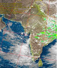
English: Satellite image of India during the 2008 monsoons as decoded by Indian amateur radio operator Mahesh Vhatkar (VU2IIA). The image was decoded by using his home-brewed equipment |
| Date | |
| Source | http://www.vu2iia.blogspot.com |
| Author | Mahesh Vhatkar |
| Permission (Reusing this file) |
Licensing
[edit]
This file is licensed under the Creative Commons Attribution 3.0 Unported license.
- You are free:
- to share – to copy, distribute and transmit the work
- to remix – to adapt the work
- Under the following conditions:
- attribution – You must give appropriate credit, provide a link to the license, and indicate if changes were made. You may do so in any reasonable manner, but not in any way that suggests the licensor endorses you or your use.
File history
Click on a date/time to view the file as it appeared at that time.
| Date/Time | Thumbnail | Dimensions | User | Comment | |
|---|---|---|---|---|---|
| current | 07:02, 25 July 2008 | | 909 × 1,099 (487 KB) | Nichalp (talk | contribs) | {{Information |Description={{en|1=Satellite image of India during the 2008 monsoons as decoded by Indian amateur radio operator Mahesh Vhatkar (VU2IIA). The image was decoded by using his home-brewed equipment}} |Source=http://www.vu2iia.blogspot.com |Aut |
You cannot overwrite this file.
File usage on Commons
The following page uses this file:
File usage on other wikis
The following other wikis use this file:
- Usage on en.wikipedia.org