File:2007SanDiegoFiresradar1008z.PNG
Jump to navigation
Jump to search
Size of this preview: 800 × 500 pixels. Other resolutions: 320 × 200 pixels | 640 × 400 pixels | 829 × 518 pixels.
Original file (829 × 518 pixels, file size: 345 KB, MIME type: image/png)
Captions
Captions
Add a one-line explanation of what this file represents
Summary
[edit]
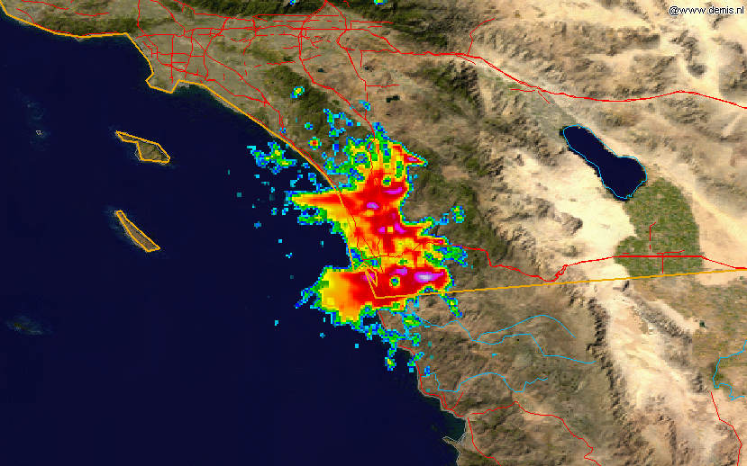
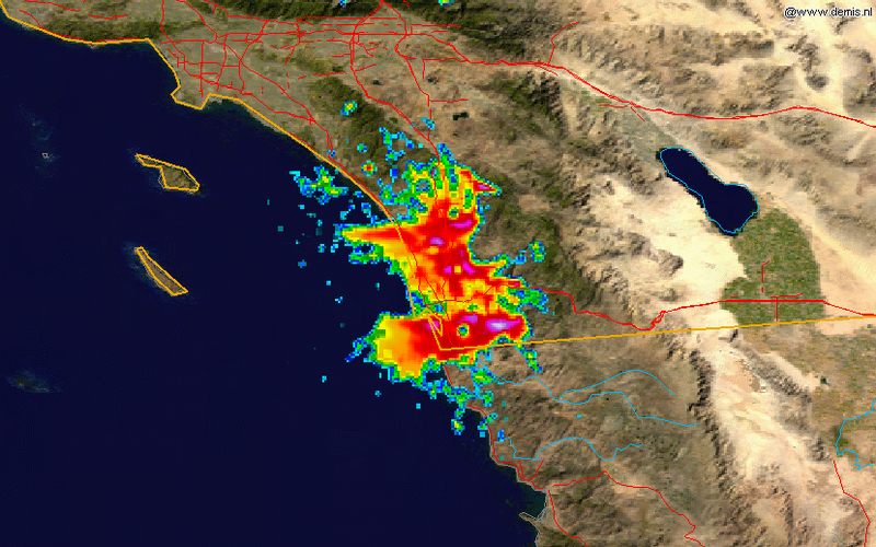
| Description | This radar image shows the smoke plume from the southern California fires of 2007 on 2007-10-23, at 10:08 UTC, overlain on a map. The data is from the NWS NEXRAD radar at KNKX (San Diego) and was processed in the NCDC's JAVA NEXRAD tool. |
| Date | |
| Source | Radar data is from the NCDC NEXRAD database and the background map is from the NASA. |
| Author | Background map by NASA. Radar data from NCDC. Image created by Hello32020. |
Licensing
[edit]
This image is in the public domain because it contains materials that originally came from the U.S. National Oceanic and Atmospheric Administration, taken or made as part of an employee's official duties.
|
| This file is in the public domain in the United States because it was solely created by NASA. NASA copyright policy states that "NASA material is not protected by copyright unless noted". (See Template:PD-USGov, NASA copyright policy page or JPL Image Use Policy.) | ||
 |
Warnings:
|
This work is based on a work in the public domain. It has been digitally enhanced and/or modified. This derivative work has been (or is hereby) released into the public domain by its author, Hello32020. This applies worldwide.
In some countries this may not be legally possible; if so: |
File history
Click on a date/time to view the file as it appeared at that time.
| Date/Time | Thumbnail | Dimensions | User | Comment | |
|---|---|---|---|---|---|
| current | 16:00, 26 October 2007 | | 829 × 518 (345 KB) | Hello32020 (talk | contribs) | == Summary == {{Information |Description=This radar image shows the smoke plume from the southern California fires of 2007 on 2007-10-23, at 10:08 a.m. GMT, overlain on a map. The data is from the NWS NEXRAD radar at KNKX (San Diego) and was processed |
You cannot overwrite this file.
File usage on Commons
There are no pages that use this file.
File usage on other wikis
The following other wikis use this file:
- Usage on ar.wikipedia.org
- Usage on de.wikipedia.org
- Usage on en.wikipedia.org
- Usage on zh.wikipedia.org