File:19860506300AR Dresden Neustädter Markt eiscafé KRISTALL.jpg
Jump to navigation
Jump to search

Size of this preview: 585 × 600 pixels. Other resolutions: 234 × 240 pixels | 468 × 480 pixels | 749 × 768 pixels | 999 × 1,024 pixels | 2,355 × 2,415 pixels.
Original file (2,355 × 2,415 pixels, file size: 3.68 MB, MIME type: image/jpeg)
Captions
Captions
Add a one-line explanation of what this file represents
Summary
[edit]| Description |
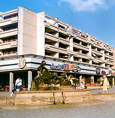
Deutsch: 06.05.1986 DDR 806 [01097] Dresden-Innere Neustadt: Neustädter Markt / Straße der Befreiung (Hauptstraße). Die Hauptstraße entstand bis 1730 nach Plänen von Wolf Caspar von Klengel. Der Großteil der alten Bebauung wurde bei der Bombardierung 1945 zerstört. Der Wiederaufbau erfolgte erst 1974 bis 1980. Das alte Straßenkonzept wurde dabei aufgegeben und ein Großteil mit fünfgeschossigen Plattenbauten WBS 70 Dresden (10.80) bebaut. Im Erdgeschoß befinden sich Handelseinrichtungen und Gastronomie. Die einstige Straße der Befreiung, die jetzt wieder Hauptstraße heißt, galt, als sie am 04.10.1979 kurz vor dem 30. Jahrestag der DDR offiziell übergeben wurde, als "schönste und freundlichste Straße" Dresdens. Hier das beliebte "eiscafé "KRISTALL" (GMP: 51.058274,13.742091). Im Vordergrund einer der beiden Brunnen, 1739-1742 von Benjamin Thomae. Heute Kopien, 1938 von Paul Polte. [R19860506A11.TIF]19860506300AR.JPG(c)Blobelt |
||||||||||||||
| Date | Taken on 6 May 1986 | ||||||||||||||
| Source | Own work | ||||||||||||||
| Author |
|
||||||||||||||

| Object location | | View this and other nearby images on: OpenStreetMap |
|---|
Licensing
[edit]
This file is licensed under the Creative Commons Attribution-Share Alike 4.0 International license.
- You are free:
- to share – to copy, distribute and transmit the work
- to remix – to adapt the work
- Under the following conditions:
- attribution – You must give appropriate credit, provide a link to the license, and indicate if changes were made. You may do so in any reasonable manner, but not in any way that suggests the licensor endorses you or your use.
- share alike – If you remix, transform, or build upon the material, you must distribute your contributions under the same or compatible license as the original.
File history
Click on a date/time to view the file as it appeared at that time.
| Date/Time | Thumbnail | Dimensions | User | Comment | |
|---|---|---|---|---|---|
| current | 21:38, 27 November 2020 | | 2,355 × 2,415 (3.68 MB) | Jörg Blobelt (talk | contribs) | Uploaded a work by {{Creator:Jörg Blobelt}} from {{own}} with UploadWizard |
You cannot overwrite this file.
File usage on Commons
The following 3 pages use this file:
File usage on other wikis
The following other wikis use this file:
- Usage on de.wikipedia.org