File:19710330010AR Dresden Innenstadt von Süden.jpg
Jump to navigation
Jump to search

Size of this preview: 800 × 418 pixels. Other resolutions: 320 × 167 pixels | 640 × 334 pixels | 1,024 × 535 pixels | 1,280 × 669 pixels | 2,560 × 1,337 pixels | 4,485 × 2,343 pixels.
Original file (4,485 × 2,343 pixels, file size: 4.06 MB, MIME type: image/jpeg)
Captions
Captions
Add a one-line explanation of what this file represents
Summary
[edit]
| Description |
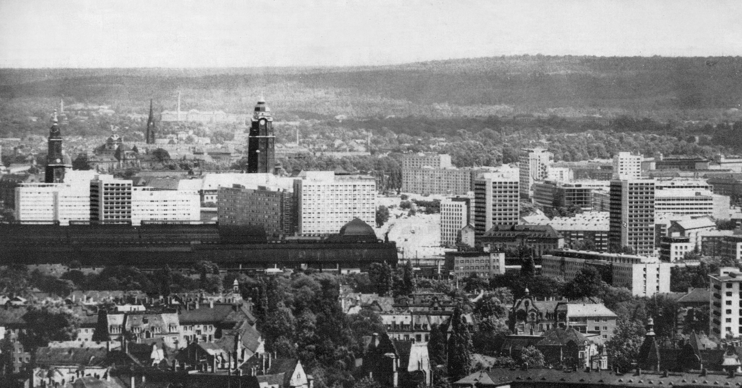
Deutsch: 30.03.1971 Dresden: Blick von Süden auf die Innenstadt. Links sieht man den Turm der Kreuzkirche (GMP: 51.048782,13.739077). Die 3 sich davor nach rechts aufreihenden Neubauten sind die Hotels Lilienstein, Königstein (GMP: 51.044411,13.735099) und Bastei an der Prager Straße. Vor diesen steht das 17-gesch. Hochhaus Reitbahnstraße 35 (GMP: 51.042561,13.733189). Weiter rechts dominiert der Rathausturm (GMP: 51.048025,13.741058) das Bild. Davor sieht man die sog. "Prager Zeile" oder "Lange Zeile"
(GMP: 51.043501,13.736181), an die sich, einige Etagen höher, das Hotel Newa (GMP: 51.042408,13.735333) anschließt. Davor das langgestreckte dunkle Dach das Hauptbahnhofes (GMP: 51.040215,13.732072). Rechts davon öffnet sich eine Baubrache. Hier entsteht mit der Leninallee (später St. Peterburger Straße) die sog. Nord-Süd-Achse. Rechts dieser Achse stehen schon die 10-geschossigen Studentenwohnheime Leningrader Straße 29 ... (GMP: 51.043080,13.737715), halb verdeckten vom höheren Gebäude Moscinskystraße 10 (GMP: 51.041801,13.736533). Zwischen diesen beiden Hochhäusern sieht man das ROBOTRON-Gelände im Bau. Am ROBOTRON-Baukörper am Pirnaischen Platz (GMP: 51.048033,13.745268) fehlt noch die Südfassade. Dahinter steht das Hochhaus "Der Sozialismus siegt" (GMP: 51.049492,13.746725) mit seinem markanten flügelartigem Flachdach. [19710330000_TGBO-21_0002.JPG]19710330010AR.JPG(Zeitungs-Repro)Blobelt |
| Date | |
| Source | Zeitungsfoto, Zeitung unbekannt. Archiv, Repro und Nachberarbeitung Dr. Jörg Blobelt |
| Author | Unknown author |
| Object location | | View this and other nearby images on: OpenStreetMap |
|---|
| Camera location | | View this and other nearby images on: OpenStreetMap |
|---|
Licensing
[edit]
This file is licensed under the Creative Commons Attribution-Share Alike 4.0 International license.
- You are free:
- to share – to copy, distribute and transmit the work
- to remix – to adapt the work
- Under the following conditions:
- attribution – You must give appropriate credit, provide a link to the license, and indicate if changes were made. You may do so in any reasonable manner, but not in any way that suggests the licensor endorses you or your use.
- share alike – If you remix, transform, or build upon the material, you must distribute your contributions under the same or compatible license as the original.
File history
Click on a date/time to view the file as it appeared at that time.
| Date/Time | Thumbnail | Dimensions | User | Comment | |
|---|---|---|---|---|---|
| current | 21:04, 6 March 2018 | | 4,485 × 2,343 (4.06 MB) | Jörg Blobelt (talk | contribs) | User created page with UploadWizard |
You cannot overwrite this file.
File usage on Commons
The following 5 pages use this file: