File:1967 data of Central and Southern African countries.jpg
Jump to navigation
Jump to search

Size of this preview: 800 × 396 pixels. Other resolutions: 320 × 158 pixels | 640 × 317 pixels | 1,024 × 507 pixels | 1,280 × 634 pixels | 2,560 × 1,268 pixels | 5,856 × 2,900 pixels.
Original file (5,856 × 2,900 pixels, file size: 2.34 MB, MIME type: image/jpeg)
Captions
Captions
Add a one-line explanation of what this file represents
Summary
[edit]
| Description |
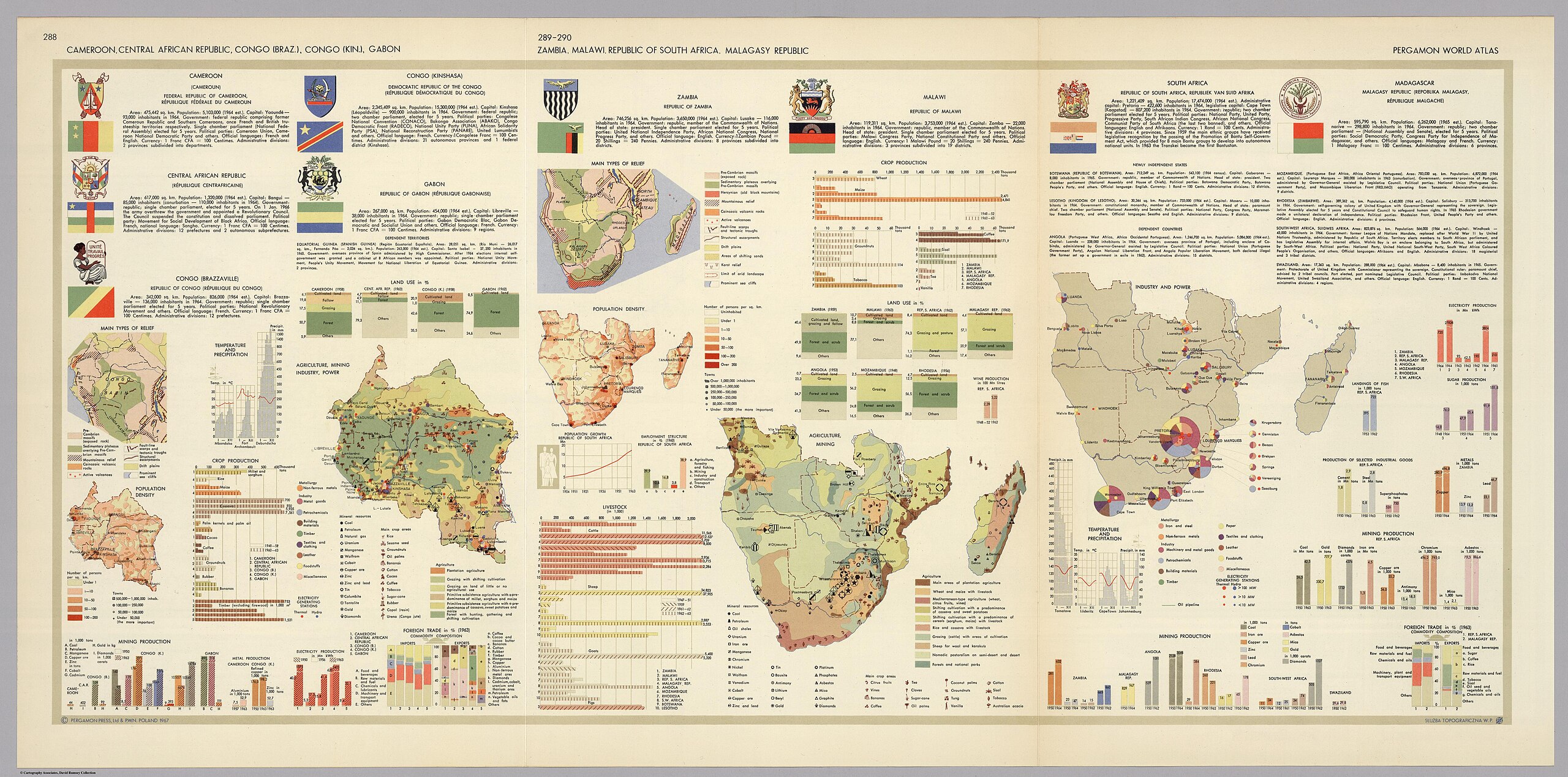
English: 20 small maps and graphs including: agriculture, population, industry, employment, climate, livestock, crops, relief types, power, mining, and foreign trade From Pergamon World Atlas |
| Date | |
| Source | David Rumsey Map Collection, list no 0737.180 |
| Author | Polish Army Topography Service |
Licensing
[edit]
This file is licensed under the Creative Commons Attribution-Share Alike 3.0 Unported license.
- You are free:
- to share – to copy, distribute and transmit the work
- to remix – to adapt the work
- Under the following conditions:
- attribution – You must give appropriate credit, provide a link to the license, and indicate if changes were made. You may do so in any reasonable manner, but not in any way that suggests the licensor endorses you or your use.
- share alike – If you remix, transform, or build upon the material, you must distribute your contributions under the same or compatible license as the original.
File history
Click on a date/time to view the file as it appeared at that time.
| Date/Time | Thumbnail | Dimensions | User | Comment | |
|---|---|---|---|---|---|
| current | 19:13, 5 February 2024 | | 5,856 × 2,900 (2.34 MB) | Babelia (talk | contribs) | Uploaded a work by Polish Army Topography Service from David Rumsey Map Collection with UploadWizard |
You cannot overwrite this file.
File usage on Commons
There are no pages that use this file.
Categories:
- Regional data maps
- 1960s maps of Zambia
- 1960s maps of Malawi
- 1960s maps of South Africa
- 1960s maps of Madagascar
- 1960s maps of Angola
- 1960s maps of Namibia
- 1960s maps of Zimbabwe
- 20th-century maps of Cameroon
- 20th-century maps of the Central African Republic
- 20th-century maps of the Republic of the Congo
- 20th-century maps of the Democratic Republic of the Congo
- 20th-century maps of Gabon