File:1946 Nankai earthquake intensity.png
Jump to navigation
Jump to search
No higher resolution available.
1946_Nankai_earthquake_intensity.png (512 × 512 pixels, file size: 50 KB, MIME type: image/png)
Captions
Captions
Add a one-line explanation of what this file represents
Summary
[edit]
| Description |
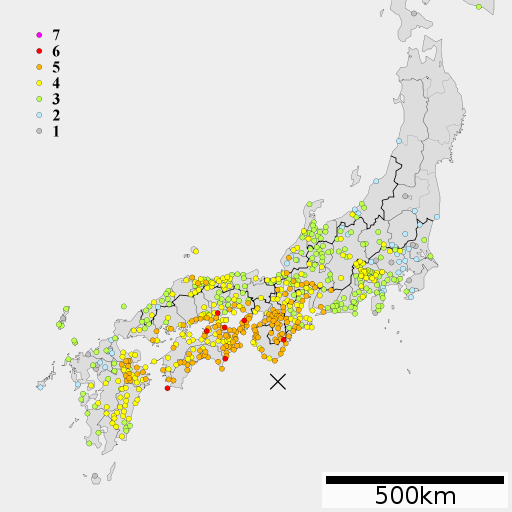
English: 1946 Nankai earthquake intensity
日本語:1946年南海地震の震度分布 |
| Date | |
| Source | Lincun(2010)ファイル:地図 令制国 和泉国.svg, 中央気象台月別全国地震調査原稿 昭和21年12月 |
| Author | As6022014 |
Licensing
[edit]
I, the copyright holder of this work, hereby publish it under the following license:
This file is licensed under the Creative Commons Attribution-Share Alike 3.0 Unported license.
- You are free:
- to share – to copy, distribute and transmit the work
- to remix – to adapt the work
- Under the following conditions:
- attribution – You must give appropriate credit, provide a link to the license, and indicate if changes were made. You may do so in any reasonable manner, but not in any way that suggests the licensor endorses you or your use.
- share alike – If you remix, transform, or build upon the material, you must distribute your contributions under the same or compatible license as the original.
File history
Click on a date/time to view the file as it appeared at that time.
| Date/Time | Thumbnail | Dimensions | User | Comment | |
|---|---|---|---|---|---|
| current | 01:13, 9 April 2012 | | 512 × 512 (50 KB) | As6022014 (talk | contribs) | {{Information |Description=南海地震の震度分布 |Source=中央気象台月別全国地震調査原稿 昭和21年12月, Lincun(2010)ファイル:地図 令制国 和泉国.svg |Date=2012-04-08 |Author=As6022014 |Permission={{self|cc-by-sa-3.0}} ... |
| 08:39, 8 March 2012 |  | 512 × 512 (53 KB) | As6022014 (talk | contribs) | {{Information |Description ={{en|1=1946 Nankai earthquake intensity}} {{ja|1=1946年南海地震の震度分布}} |Source =Lincun(2010)ファイル:地図 令制国 和泉国.svg, 中央気象台月別全国地震調査原稿 昭和21年12�... |
You cannot overwrite this file.
File usage on Commons
The following page uses this file:
File usage on other wikis
The following other wikis use this file:
- Usage on en.wikipedia.org
- Usage on es.wikipedia.org
- Usage on id.wikipedia.org
- Usage on ja.wikipedia.org
- Usage on ko.wikipedia.org
- Usage on www.wikidata.org
- Usage on zh.wikipedia.org