File:1940 Census Enumeration District Descriptions - North Dakota - McLean County - ED 28-56, ED 28-57, ED 28-58, ED 28-59, ED 28-60, ED 28-61, ED 28-62 - NARA - 5873956.jpg

Original file (4,712 × 2,472 pixels, file size: 784 KB, MIME type: image/jpeg)
Captions
Captions
Summary
[edit]
| 1940 Census Enumeration District Descriptions - North Dakota - McLean County - ED 28-56, ED 28-57, ED 28-58, ED 28-59, ED 28-60, ED 28-61, ED 28-62
( |
|||||||||||||||||||||||||||
|---|---|---|---|---|---|---|---|---|---|---|---|---|---|---|---|---|---|---|---|---|---|---|---|---|---|---|---|
| Author |
Unknown author or not provided |
||||||||||||||||||||||||||
| Record creator | Department of the Interior. 11th Decennial Census Office. 3rd Division - Geography. ca. 1889-ca. 1894 | ||||||||||||||||||||||||||
| Title |
1940 Census Enumeration District Descriptions - North Dakota - McLean County - ED 28-56, ED 28-57, ED 28-58, ED 28-59, ED 28-60, ED 28-61, ED 28-62 |
||||||||||||||||||||||||||
| Description |
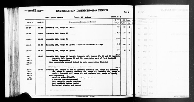
ND ED 28-56: TOWNSHIP 145 RANGE 84 (PART). ND ED 28-57: TOWNSHIP 146 RANGE 80. ND ED 28-58: TOWNSHIP 146 RANGE 81. ND ED 28-59: TOWNSHIP 146 RANGE 82 (PART) OUTSIDE UNDERWOOD VILLAGE. ND ED 28-60: TOWNSHIP 146 RANGE 84 (PART). ND ED 28-61: TOWNSHIP 146 RANGE 88 (PART), TOWNSHIP 147 RANGES 87, 88, AND 89 (PARTS), AND TOWNSHIP 148 RANGES 88 AND 89 COMPRISING PART OF FORT BERTHOLD INDIAN RESERVATION; UNNAMED ISLAND. ND ED 28-62: TOWNSHIP 147 RANGES 90 AND 91 (PARTS), TOWNSHIP 148 RANGE 90, TOWNSHIP 148 RANGE 91 (PART), TOWNSHIP 149 RANGE 90, TOWNSHIP 149 RANGE 91 (PART), TOWNSHIP 150 RANGE 90, AND TOWNSHIP 150 RANGE 91 (PART); CATHOLIC MISSION BOARDING SCHOOL, ELBOWOODS, FORT BERTHOLD INDIAN HOSPITAL, FORT BERTHOLD INDIAN SCHOOL, PROTESTANT MISSION AND SCHOOL. |
||||||||||||||||||||||||||
| Date | 1850 – 1950 | ||||||||||||||||||||||||||
| Collection |
|
||||||||||||||||||||||||||
| Record ID |
|
||||||||||||||||||||||||||
| Source | U.S. National Archives and Records Administration | ||||||||||||||||||||||||||
| Other versions |
Please do not overwrite this file: any restoration work should be uploaded with a new name and linked in this page's "other versions=" parameter, so that this file represents the exact file found in the NARA catalog record to which it links. The metadata on this page was imported directly from NARA's catalog record; additional descriptive text may be added by Wikimedians to the template below with the "description=" parameter, but please do not modify the other fields. |
||||||||||||||||||||||||||
Licensing
[edit]
This file was provided to Wikimedia Commons by the National Archives and Records Administration as part of a cooperation project. The National Archives and Records Administration provides images depicting American and global history which are public domain or licensed under a free license.
|
This image or file is a work of a United States Census Bureau employee, taken or made as part of that person's official duties. As a work of the U.S. federal government, the image is in the public domain.
|
 |
File history
Click on a date/time to view the file as it appeared at that time.
| Date/Time | Thumbnail | Dimensions | User | Comment | |
|---|---|---|---|---|---|
| current | 19:36, 26 July 2019 | | 4,712 × 2,472 (784 KB) | US National Archives bot (talk | contribs) | Bot-assisted upload of US National Archives Identifer 5873956. |
You cannot overwrite this file.
File usage on Commons
The following page uses this file: