File:1940 Census Enumeration District Descriptions - North Dakota - McKenzie County - ED 27-1, ED 27-2, ED 27-3, ED 27-4, ED 27-5, ED 27-6, ED 27-7, ED 27-8, ED 27-9, ED 27-10, ED 27-11 - NARA - 5873943.jpg
Original file (4,712 × 2,472 pixels, file size: 775 KB, MIME type: image/jpeg)
Captions
Captions
Summary
[edit]
| 1940 Census Enumeration District Descriptions - North Dakota - McKenzie County - ED 27-1, ED 27-2, ED 27-3, ED 27-4, ED 27-5, ED 27-6, ED 27-7, ED 27-8, ED 27-9, ED 27-10, ED 27-11
( |
|||||||||||||||||||||||||||
|---|---|---|---|---|---|---|---|---|---|---|---|---|---|---|---|---|---|---|---|---|---|---|---|---|---|---|---|
| Author |
Unknown author or not provided |
||||||||||||||||||||||||||
| Record creator | Department of the Interior. 11th Decennial Census Office. 3rd Division - Geography. ca. 1889-ca. 1894 | ||||||||||||||||||||||||||
| Title |
1940 Census Enumeration District Descriptions - North Dakota - McKenzie County - ED 27-1, ED 27-2, ED 27-3, ED 27-4, ED 27-5, ED 27-6, ED 27-7, ED 27-8, ED 27-9, ED 27-10, ED 27-11 |
||||||||||||||||||||||||||
| Description |
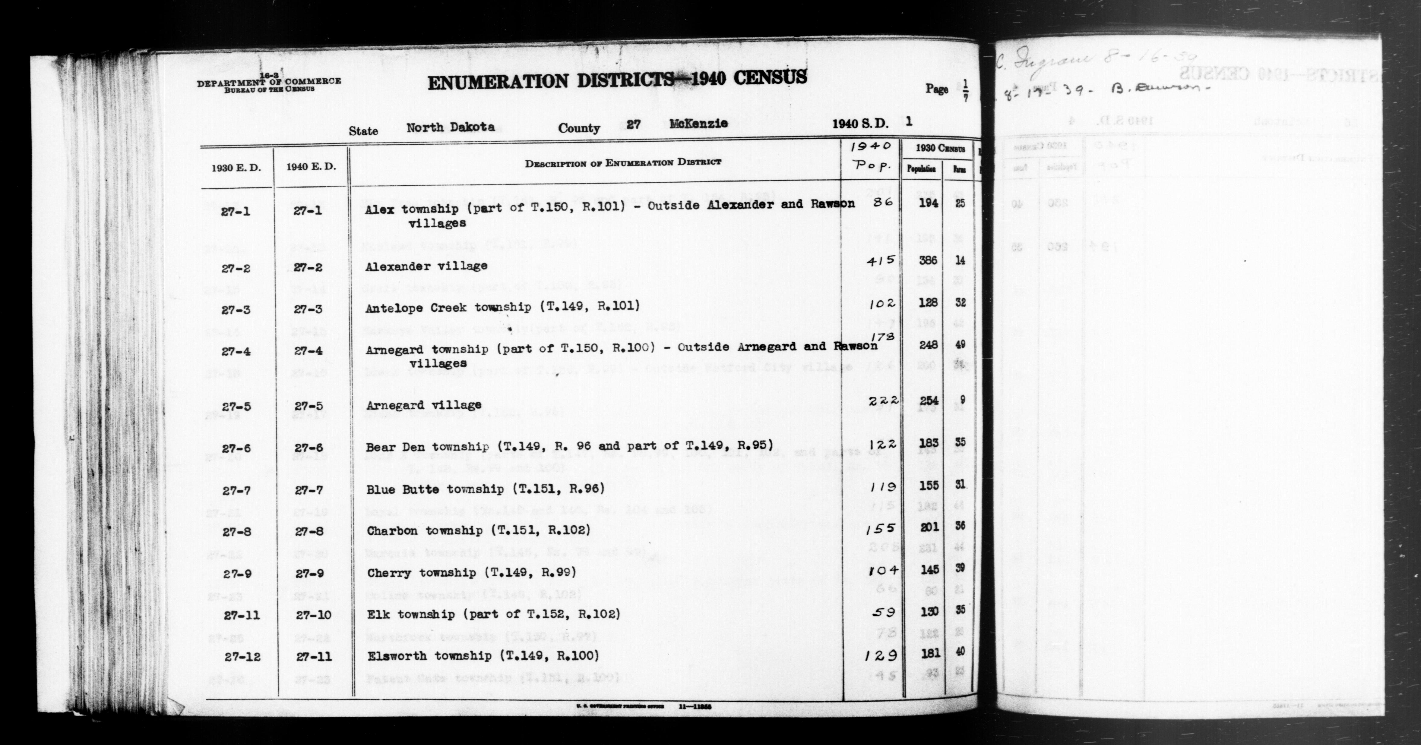
ND ED 27-1: ALEX TOWNSHIP (TOWNSHIP 150 RANGE 101 (PART)) OUTSIDE ALEXANDER AND RAWSON VILLAGES. ND ED 27-2: ALEXANDER VILLAGE. ND ED 27-3: ANTELOPE CREEK TOWNSHIP (TOWNSHIP 149 RANGE 101). ND ED 27-4: ARNEGARD TOWNSHIP (TOWNSHIP 150 RANGE 100 (PART)) OUTSIDE ARNEGARD AND RAWSON VILLAGES. ND ED 27-5: ARNEGARD VILLAGE. ND ED 27-6: BEAR DEN TOWNSHIP (TOWNSHIP 149 RANGE 96 AND TOWNSHIP 149 RANGE 95 (PART)). ND ED 27-7: BLUE BUTTE TOWNSHIP (TOWNSHIP 151 RANGE 96). ND ED 27-8: CHARBON TOWNSHIP (TOWNSHIP 151 RANGE 102). ND ED 27-9: CHERRY TOWNSHIP (TOWNSHIP 149 RANGE 99). ND ED 27-10: ELK TOWNSHIP (TOWNSHIP 152 RANGE 102 (PART)). ND ED 27-11: ELSWORTH TOWNSHIP (TOWNSHIP 149 RANGE 100). |
||||||||||||||||||||||||||
| Date | 1850 – 1950 | ||||||||||||||||||||||||||
| Collection |
|
||||||||||||||||||||||||||
| Record ID |
|
||||||||||||||||||||||||||
| Source | U.S. National Archives and Records Administration | ||||||||||||||||||||||||||
| Other versions |
Please do not overwrite this file: any restoration work should be uploaded with a new name and linked in this page's "other versions=" parameter, so that this file represents the exact file found in the NARA catalog record to which it links. The metadata on this page was imported directly from NARA's catalog record; additional descriptive text may be added by Wikimedians to the template below with the "description=" parameter, but please do not modify the other fields. |
||||||||||||||||||||||||||
Licensing
[edit]
This file was provided to Wikimedia Commons by the National Archives and Records Administration as part of a cooperation project. The National Archives and Records Administration provides images depicting American and global history which are public domain or licensed under a free license.
|
This image or file is a work of a United States Census Bureau employee, taken or made as part of that person's official duties. As a work of the U.S. federal government, the image is in the public domain.
|
 |
File history
Click on a date/time to view the file as it appeared at that time.
| Date/Time | Thumbnail | Dimensions | User | Comment | |
|---|---|---|---|---|---|
| current | 19:34, 26 July 2019 | | 4,712 × 2,472 (775 KB) | US National Archives bot (talk | contribs) | Bot-assisted upload of US National Archives Identifer 5873943. |
You cannot overwrite this file.
File usage on Commons
The following page uses this file: