File:1940 Census Enumeration District Descriptions - Maine - Knox County - ED 7-34, ED 7-35, ED 7-36 - NARA - 5866719.jpg
Original file (4,712 × 2,488 pixels, file size: 771 KB, MIME type: image/jpeg)
Captions
Captions
Summary
[edit]
| 1940 Census Enumeration District Descriptions - Maine - Knox County - ED 7-34, ED 7-35, ED 7-36
( |
|||||||||||||||||||||||||||
|---|---|---|---|---|---|---|---|---|---|---|---|---|---|---|---|---|---|---|---|---|---|---|---|---|---|---|---|
| Author |
Unknown author or not provided |
||||||||||||||||||||||||||
| Record creator | Department of the Interior. 11th Decennial Census Office. 3rd Division - Geography. ca. 1889-ca. 1894 | ||||||||||||||||||||||||||
| Title |
1940 Census Enumeration District Descriptions - Maine - Knox County - ED 7-34, ED 7-35, ED 7-36 |
||||||||||||||||||||||||||
| Description |
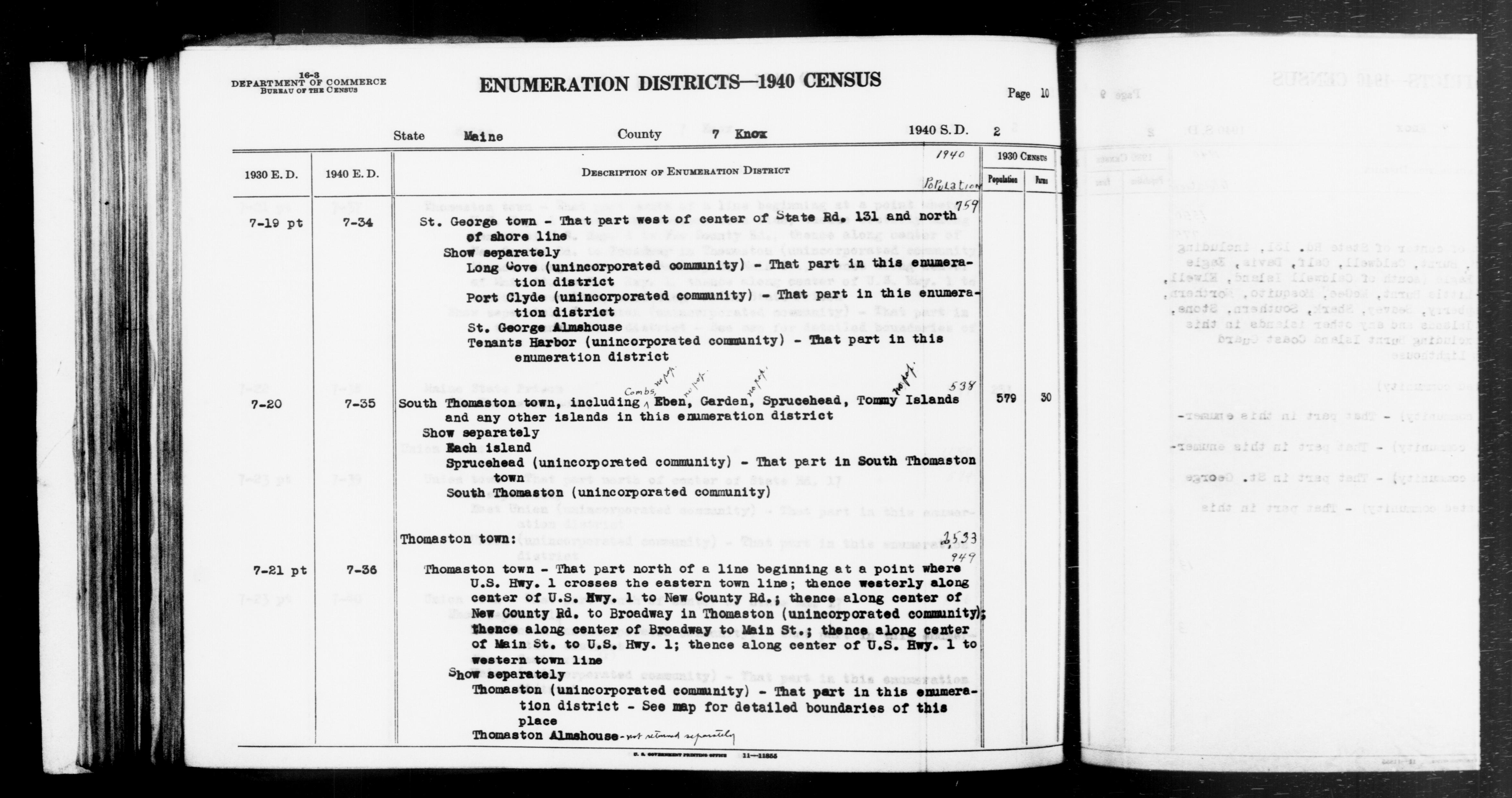
ME ED 7-34: ST. GEORGE TOWN W OF CENTER OF STATE ROAD 131 AND N OF SHORE LINE, LONG COVE (PART), PORT CLYDE (PART), ST. GEORGE ALMSHOUSE, TENANTS HARBOR (PART). ME ED 7-35: SOUTH THOMASTON TOWN, COMBS ISLAND, EBEN ISLAND, GARDEN ISLAND, SOUTH THOMASTON, SPRUCEHEAD (PART), SPRUCEHEAD ISLAND, TOMMY ISLAND, ISLANDS. ME ED 7-36: THOMASTON TOWN N OF A LINE BEGINNING WHERE U.S. HIGHWAY 1 CROSSES EASTERN TOWN LINE, THEN WESTERLY ALONG CENTER OF U.S. HIGHWAY 1 TO NEW COUNTY RD, THEN ALONG CENTER OF NEW COUNTY RD TO BROADWAY IN THOMASTON, THEN ALONG CENTER OF BROADWAY TO MAIN ST, THEN ALONG CENTER OF MAIN ST TO U.S. HIGHWAY 1, AND THEN ALONG CENTER OF U.S. HIGHWAY 1 TO WESTERN TOWN LINE; THOMASTON (PART), THOMASTON ALMSHOUSE. |
||||||||||||||||||||||||||
| Date | 1850 – 1950 | ||||||||||||||||||||||||||
| Collection |
|
||||||||||||||||||||||||||
| Record ID |
|
||||||||||||||||||||||||||
| Source | U.S. National Archives and Records Administration | ||||||||||||||||||||||||||
| Other versions |
Please do not overwrite this file: any restoration work should be uploaded with a new name and linked in this page's "other versions=" parameter, so that this file represents the exact file found in the NARA catalog record to which it links. The metadata on this page was imported directly from NARA's catalog record; additional descriptive text may be added by Wikimedians to the template below with the "description=" parameter, but please do not modify the other fields. |
||||||||||||||||||||||||||
Licensing
[edit]
This file was provided to Wikimedia Commons by the National Archives and Records Administration as part of a cooperation project. The National Archives and Records Administration provides images depicting American and global history which are public domain or licensed under a free license.
|
This image or file is a work of a United States Census Bureau employee, taken or made as part of that person's official duties. As a work of the U.S. federal government, the image is in the public domain.
|
 |
File history
Click on a date/time to view the file as it appeared at that time.
| Date/Time | Thumbnail | Dimensions | User | Comment | |
|---|---|---|---|---|---|
| current | 19:25, 24 July 2019 | | 4,712 × 2,488 (771 KB) | US National Archives bot (talk | contribs) | Bot-assisted upload of US National Archives Identifer 5866719. |
You cannot overwrite this file.
File usage on Commons
The following page uses this file: