File:1940 Census Enumeration District Descriptions - Kentucky - Calloway County - ED 18-5, ED 18-6, ED 18-7, ED 18-8, ED 18-9, ED 18-10 - NARA - 5862340.jpg

Original file (4,424 × 2,536 pixels, file size: 688 KB, MIME type: image/jpeg)
Captions
Captions
Summary
[edit]
| 1940 Census Enumeration District Descriptions - Kentucky - Calloway County - ED 18-5, ED 18-6, ED 18-7, ED 18-8, ED 18-9, ED 18-10
( |
|||||||||||||||||||||||||||
|---|---|---|---|---|---|---|---|---|---|---|---|---|---|---|---|---|---|---|---|---|---|---|---|---|---|---|---|
| Author |
Unknown author or not provided |
||||||||||||||||||||||||||
| Record creator | Department of the Interior. 11th Decennial Census Office. 3rd Division - Geography. ca. 1889-ca. 1894 | ||||||||||||||||||||||||||
| Title |
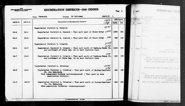
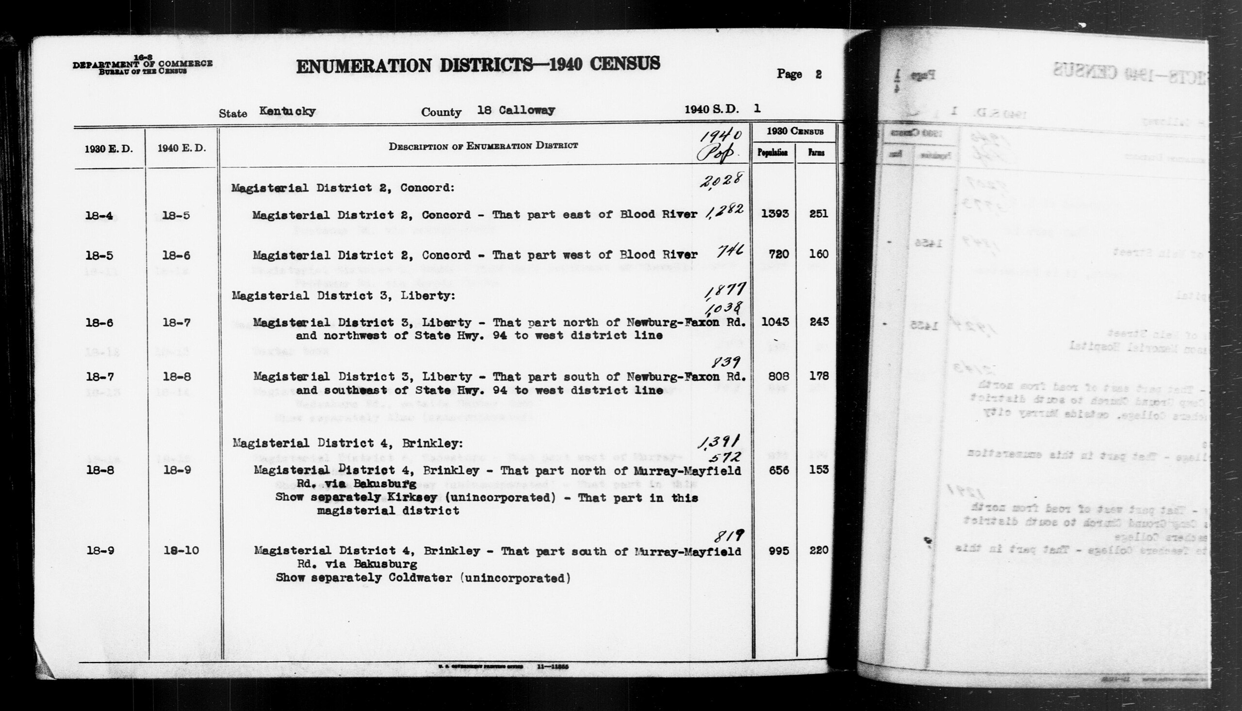
1940 Census Enumeration District Descriptions - Kentucky - Calloway County - ED 18-5, ED 18-6, ED 18-7, ED 18-8, ED 18-9, ED 18-10 |
||||||||||||||||||||||||||
| Description |
KY ED 18-5: MAGISTERIAL DISTRICT 2 CONCORD E OF BLOOD RIVER. KY ED 18-6: MAGISTERIAL DISTRICT 2 CONCORD W OF BLOOD RIVER. KY ED 18-7: MAGISTERIAL DISTRICT 3 LIBERTY N OF NEWBURG-FAXON RD AND NW OF STATE HIGHWAY 94 TO W DISTRICT LINE. KY ED 18-8: MAGISTERIAL DISTRICT 3 LIBERTY S OF NEWBURG-FAXON RD AND SE OF STATE HIGHWAY 94 TO W DISTRICT LINE. KY ED 18-9: MAGISTERIAL DISTRICT 4 BRINKLEY N OF MURRAY-MAYFIELD RD VIA BAKUSBURG, KIRKSEY (PART). KY ED 18-10: MAGISTERIAL DISTRICT 4 BRINKLEY S OF MURRAY-MAYFIELD RD VIA BAKUSBURG, COLDWATER. |
||||||||||||||||||||||||||
| Date | 1850 – 1950 | ||||||||||||||||||||||||||
| Collection |
|
||||||||||||||||||||||||||
| Record ID |
|
||||||||||||||||||||||||||
| Source | U.S. National Archives and Records Administration | ||||||||||||||||||||||||||
| Other versions |
Please do not overwrite this file: any restoration work should be uploaded with a new name and linked in this page's "other versions=" parameter, so that this file represents the exact file found in the NARA catalog record to which it links. The metadata on this page was imported directly from NARA's catalog record; additional descriptive text may be added by Wikimedians to the template below with the "description=" parameter, but please do not modify the other fields. |
||||||||||||||||||||||||||
Licensing
[edit]
This file was provided to Wikimedia Commons by the National Archives and Records Administration as part of a cooperation project. The National Archives and Records Administration provides images depicting American and global history which are public domain or licensed under a free license.
|
This image or file is a work of a United States Census Bureau employee, taken or made as part of that person's official duties. As a work of the U.S. federal government, the image is in the public domain.
|
 |
File history
Click on a date/time to view the file as it appeared at that time.
| Date/Time | Thumbnail | Dimensions | User | Comment | |
|---|---|---|---|---|---|
| current | 14:04, 24 July 2019 | | 4,424 × 2,536 (688 KB) | US National Archives bot (talk | contribs) | Bot-assisted upload of US National Archives Identifer 5862340. |
You cannot overwrite this file.
File usage on Commons
The following page uses this file: