File:1930 Pictorial Map of North America and South America - Geographicus - PanAmericanHighway-standardoil-1930.jpg
Jump to navigation
Jump to search

Size of this preview: 440 × 600 pixels. Other resolutions: 176 × 240 pixels | 352 × 480 pixels | 563 × 768 pixels | 751 × 1,024 pixels | 1,502 × 2,048 pixels | 3,500 × 4,771 pixels.
Original file (3,500 × 4,771 pixels, file size: 4.96 MB, MIME type: image/jpeg)
Captions
Captions
Add a one-line explanation of what this file represents
| Pictorial Map of the American Continent Following the Pan American Highway | |||||
|---|---|---|---|---|---|
| Artist | |||||
| Title |
Pictorial Map of the American Continent Following the Pan American Highway |
||||
| Description |
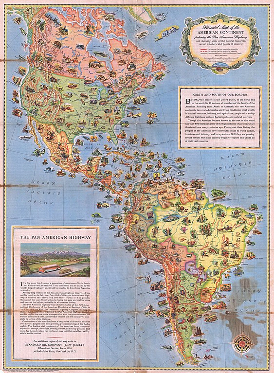
English: This is a very attractive and beautifully illustrated c. 1930 pictorial map of North America and South America drawn to illustrate the Pan-American Highway. The Pan-American Highway is a network of roads measuring about 29,800 miles in length. Except for an 87 kilometers 54 mile rainforest break, called the Darién Gap, the road links the mainland nations of the Americas in a single connected highway system. Covering both the North and South American continent, this map features dozens of vignettes, illustrating popular activities and wildlife found throughout. The upper right quadrant describes the American continents outside the US border. The lower left quadrant offers a brief history of the Pan American Highway. The verso features a listing of countries and territories outside the US, titled “Know Your Neighbors Better” and gives a short, detailed history of each country The map was published by John Rockefeller’s Standard Oil Company using bipolar oblique conic conformal projection. |
||||
| Date | circa 1930(undated) | ||||
| Dimensions | height: 24 in (60.9 cm); width: 18 in (45.7 cm) | ||||
| Accession number |
Geographicus link: PanAmericanHighway-standardoil-1930 |
||||
| Source/Photographer |
|
||||
| Permission (Reusing this file) |
|
||||

File history
Click on a date/time to view the file as it appeared at that time.
| Date/Time | Thumbnail | Dimensions | User | Comment | |
|---|---|---|---|---|---|
| current | 01:03, 25 March 2011 | | 3,500 × 4,771 (4.96 MB) | BotMultichillT (talk | contribs) | {{subst:User:Multichill/Geographicus |link=http://www.geographicus.com/P/AntiqueMap/PanAmericanHighway-standardoil-1930 |product_name=1930 Pictorial Map of North America and South America |map_title=Pictorial Map of the American Continent Following the Pa |
You cannot overwrite this file.
File usage on Commons
The following page uses this file: