File:1927 East Bay Electric Lines and Key System map.jpg
Jump to navigation
Jump to search

Size of this preview: 800 × 420 pixels. Other resolutions: 320 × 168 pixels | 640 × 336 pixels | 1,024 × 538 pixels | 1,280 × 673 pixels | 2,560 × 1,345 pixels | 5,952 × 3,128 pixels.
Original file (5,952 × 3,128 pixels, file size: 5.21 MB, MIME type: image/jpeg)
Captions
Captions
Add a one-line explanation of what this file represents
| Description |
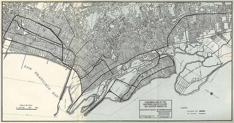
English: May 1927 map showing the East Bay Electric Lines and the Key System commuter trains, produced as part of a report on the then-proposed Transbay Bridge. The map incorrectly identifies the Ellsworth Line as being part of the Key Route system; it was in fact part of the East Bay Electric Lines. |
| Date | |
| Source | Suburban Lines of the Southern Pacific Co and Key System Transit Co to Accompany Report on Transbay Bridge (1927) |
| Author | City of San Francisco |
Licensing
[edit]
This image is in the public domain because it is a mere mechanical scan or photocopy of a public domain original, or – from the available evidence – is so similar to such a scan or photocopy that no copyright protection can be expected to arise. The original itself is in the public domain for the following reason:
This tag is designed for use where there may be a need to assert that any enhancements (eg brightness, contrast, colour-matching, sharpening) are in themselves insufficiently creative to generate a new copyright. It can be used where it is unknown whether any enhancements have been made, as well as when the enhancements are clear but insufficient. For known raw unenhanced scans you can use an appropriate {{PD-old}} tag instead. For usage, see Commons:When to use the PD-scan tag.  |
File history
Click on a date/time to view the file as it appeared at that time.
| Date/Time | Thumbnail | Dimensions | User | Comment | |
|---|---|---|---|---|---|
| current | 21:51, 5 May 2016 | | 5,952 × 3,128 (5.21 MB) | Pi.1415926535 (talk | contribs) | {{Information |Description ={{en|1=May 1927 map showing the East Bay Electric Lines and the Key System commuter trains, produced as part of a report on the then-proposed Transbay Bridge. The map incorrectly identifies the Ellsworth Line as being par... |
You cannot overwrite this file.
File usage on Commons
The following 4 pages use this file: