File:1920prescountymap2.PNG
Jump to navigation
Jump to search
Size of this preview: 800 × 520 pixels. Other resolutions: 320 × 208 pixels | 640 × 416 pixels | 1,024 × 665 pixels | 1,513 × 983 pixels.
Original file (1,513 × 983 pixels, file size: 196 KB, MIME type: image/png)
Captions
Captions
Add a one-line explanation of what this file represents
Summary
[edit]
| Description |
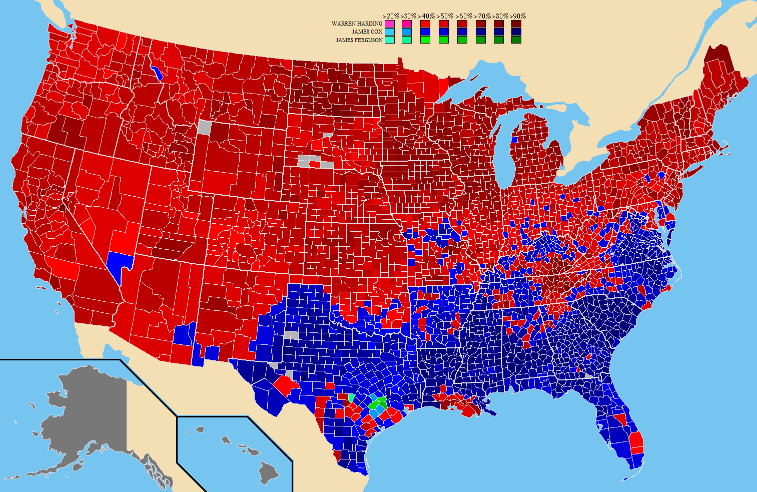
English: A map of the counties won by each candidate in the United States presidential election. Português: Mapa dos resultados da eleição presidencial dos EUA de 1920 por cidades. |
| Date | |
| Source |
Own work (Original caption: " I created this work entirely by myself. ") |
| Author | Tilden76 at English Wikipedia |
Licensing
[edit]
Tilden76 at English Wikipedia, the copyright holder of this work, hereby publishes it under the following license:
This file is licensed under the Creative Commons Attribution 3.0 Unported license.
Attribution: Tilden76 at English Wikipedia
- You are free:
- to share – to copy, distribute and transmit the work
- to remix – to adapt the work
- Under the following conditions:
- attribution – You must give appropriate credit, provide a link to the license, and indicate if changes were made. You may do so in any reasonable manner, but not in any way that suggests the licensor endorses you or your use.
Original upload log
[edit]
Transferred from en.wikipedia to Commons by Magog the Ogre using CommonsHelper.
The original description page was here. All following user names refer to en.wikipedia.
- 2009-06-07 05:57 Tilden76 1513×983× (201074 bytes) {{Information |Description = A map of the counties won by each candidate in the [[United States presidential election, 1920]]. |Source = I created this work entirely by myself. |Date = June 7, 2009 |Author = Tilden76 |Per
File history
Click on a date/time to view the file as it appeared at that time.
| Date/Time | Thumbnail | Dimensions | User | Comment | |
|---|---|---|---|---|---|
| current | 19:08, 12 October 2011 | | 1,513 × 983 (196 KB) | File Upload Bot (Magnus Manske) (talk | contribs) | {{BotMoveToCommons|en.wikipedia|year={{subst:CURRENTYEAR}}|month={{subst:CURRENTMONTHNAME}}|day={{subst:CURRENTDAY}}}} {{Information |Description={{en|A map of the counties won by each candidate in the en:United States presidential election, 1920.} |
You cannot overwrite this file.
File usage on Commons
The following 2 pages use this file:
- File:1920prescountymap.PNG
- File:1920presidentialcountymap2.PNG (file redirect)
File usage on other wikis
The following other wikis use this file:
- Usage on pt.wikipedia.org