File:1905 Karte Helfe, Gemarkung Boele.png
Jump to navigation
Jump to search

Size of this preview: 800 × 452 pixels. Other resolutions: 320 × 181 pixels | 640 × 361 pixels | 1,024 × 578 pixels | 1,493 × 843 pixels.
Original file (1,493 × 843 pixels, file size: 2.35 MB, MIME type: image/png)
Captions
Captions
Add a one-line explanation of what this file represents
Summary
[edit]
| Description |
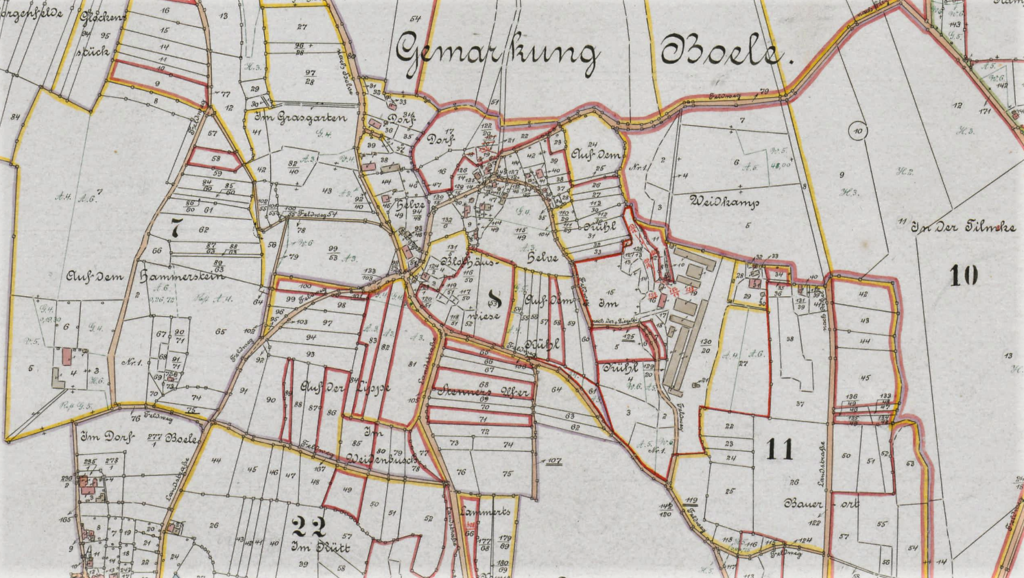
Deutsch: Das Dorf Helfe in einem Kartenausschnitt der Karte: „Boele (Hagen) Fley (Hagen) Katasterauszug mit eingetragenen Grundstücken des Hauses Busch 1905. Kolorierte Zeichnung Haus Busch Nr. 15.“ |
| Date | |
| Source | Landesarchiv NRW Abteilung Westfalen W 051 / Karten A (Allgemein), Nr. 10172 – DFG-Viewer |
| Author | Unbekannter Zeichner |
Licensing
[edit]
|
This work is in the public domain in its country of origin and other countries and areas where the copyright term is the author's life plus 100 years or fewer. This work is in the public domain in the United States because it was published (or registered with the U.S. Copyright Office) before January 1, 1929. | |
| This file has been identified as being free of known restrictions under copyright law, including all related and neighboring rights. | |
File history
Click on a date/time to view the file as it appeared at that time.
| Date/Time | Thumbnail | Dimensions | User | Comment | |
|---|---|---|---|---|---|
| current | 13:21, 18 January 2022 | | 1,493 × 843 (2.35 MB) | Bärwinkel,Klaus (talk | contribs) | {{Information |Description={{de|1=Das Dorf Helfe in einem Kartenausschnitt der Karte: „Boele (Hagen) Fley (Hagen) Katasterauszug mit eingetragenen Grundstücken des Hauses Busch 1905. Kolorierte Zeichnung Haus Busch Nr. 15.“}} |Source=Landesarchiv NRW Abt. Westfalen – DFG-Viewer |Date=1905 |Author=Landesarchiv NRW Abteilung Westfalen W 051 / Karten A (Allgemein), Nr. 10172 |Permission= |other_versions= }} == {{int:license}} == {{free screenshot|license={{GPL}} }} Category:Helfe (Hagen) |
You cannot overwrite this file.
File usage on Commons
There are no pages that use this file.