File:1886 Spanish nautical map of Federated States of Micronesia islands.jpg
Original file (4,584 × 5,412 pixels, file size: 1.63 MB, MIME type: image/jpeg)
Captions
Captions
Summary
[edit]| Description |
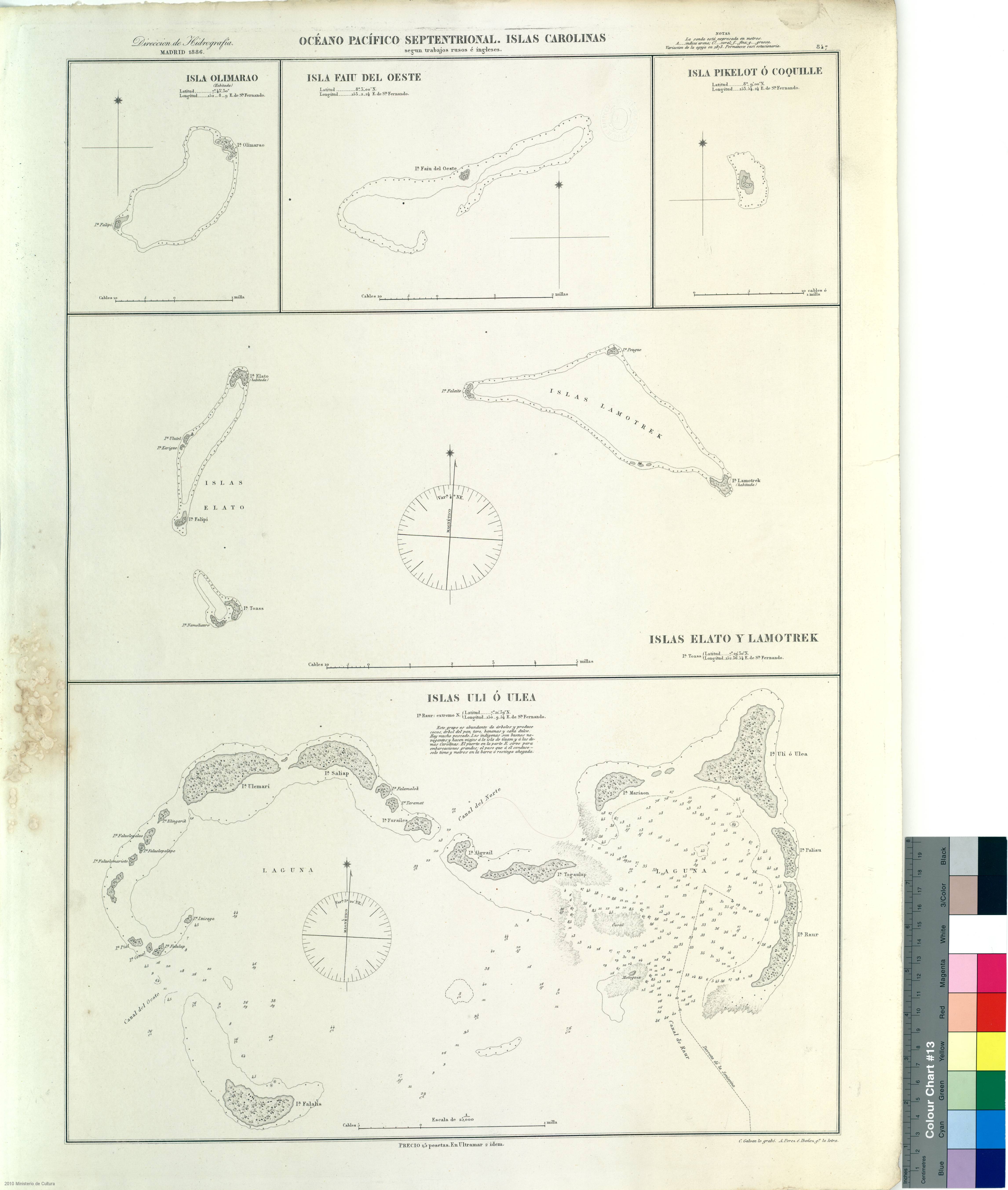
Español: Islas Olimarao, Faiu del Oeste, Pikelot, Elato, Lamotrek y Uli (Woleai) pertenecientes a los Estados Federados de Micronesia según los trabajos rusos e ingleses.
Madrid : Dirección de Hidrografía, 1886. 63 x 45 cm C. Galván lo grabó, A. Pérez e Ibáñez go. la letraEnglish: 1886 nautical map in Spanish by Clemente Galván (engraving) and A. Pérez e Ibañez (text), after Russian and English works.
The map shows Olimaraos, Piagailoe (West Fayu), Pikelot, Elato, Lamotrek and Woleai islands (Islas Uli). Madrid, Dirección de Hidrografía, 1886. 63 x 45 cmFrançais : Carte marine espagnole de 1886 par Clemente Galván (gravure) et A. Pérez e Ibañez (texte), réalisée à partir de travaux russes et anglais.
La carte montre les îles de Olimaras, Piagailoe (West Fayu), Pikelot, Elato, Lamotrek et l'archipel Woleai (dénommé "Islas Uli" sur la carte). Madrid, Dirección de Hidrografía, 1886. 63 x 45 cm |
| Date | |
| Source | http://bvpb.mcu.es/es/consulta/registro.cmd?id=441537 |
| Author | Galván, Clemente |
| Other versions |


Licensing
[edit]
|
This work is in the public domain in its country of origin and other countries and areas where the copyright term is the author's life plus 70 years or fewer. This work is in the public domain in the United States because it was published (or registered with the U.S. Copyright Office) before January 1, 1929. | |
| This file has been identified as being free of known restrictions under copyright law, including all related and neighboring rights. | |
File history
Click on a date/time to view the file as it appeared at that time.
| Date/Time | Thumbnail | Dimensions | User | Comment | |
|---|---|---|---|---|---|
| current | 16:24, 22 October 2016 | | 4,584 × 5,412 (1.63 MB) | Skimel (talk | contribs) | User created page with UploadWizard |
You cannot overwrite this file.
File usage on Commons
The following 5 pages use this file:
File usage on other wikis
The following other wikis use this file:
- Usage on de.wikipedia.org
- Usage on en.wikipedia.org
- Usage on es.wikipedia.org