File:1885 Gettysburg and Harrisburg Railroad.png
Jump to navigation
Jump to search

Size of this preview: 569 × 600 pixels. Other resolutions: 228 × 240 pixels | 455 × 480 pixels | 778 × 820 pixels.
Original file (778 × 820 pixels, file size: 180 KB, MIME type: image/png)
Captions
Captions
Add a one-line explanation of what this file represents
Summary
[edit]
| Description |
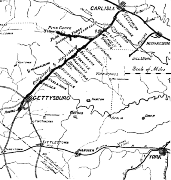
English: "The Gettysburg and Harrisburg Railroad And Connections"--The G & H RR]] in 1885 was between Hunter's Run south to Gettysburg and, via its Round Top Branch, Round Top. The railroad's north connection was with the South Mountain RR, which ran between Pine Grove Iron Works and used Gettysburg Junction to connect the Cumberland Valley RR.[1] The south connection (not shown) was at Gettysburg with the east-west Hanover Junction, Hanover & Gettysburg RR.
name on map -- subsequent name H & P. Juntn. -- Carlisle Junction Hamton -- Hampton Oxford -- New Oxford Berlin -- East Berlin Spring Forge -- Spring Grove |
| Date | after May 25, 1885 ... "Table Rock" first appeared on the schedule of May 25, 1885; "Zion Church"[2] did not appear on G&H schedules from April 1884-May 1886, and "Bendersville Sta." had been moved southward to Aspers Station by 1888.[1] |
| Source | 1885 map |
| Author | Unknown author |
| Permission (Reusing this file) |
published before 1923 in the United States |
Licensing
[edit]
This media file is in the public domain in the United States. This applies to U.S. works where the copyright has expired, often because its first publication occurred prior to January 1, 1929, and if not then due to lack of notice or renewal. See this page for further explanation.
|
 | |
 |
- ↑ Balch, William Ralston (1885) The Battle of Gettysburg: An Historical Account (Google Books), Harrisburg, Pennsylvania: Lane S. Hart Retrieved on 9 June 2011.
- ↑ Cathell, Dave. Rail Fan Day November 20, 2004. Pioneer Lines Scenic Railroad. DaveCathell.tripod.com. Retrieved on 2011-07-03. "After the Wolfpit climb, the G&H continues upgrade past Gardeners, Idaville and to the Cumberland County line at Starners, where the line's top elevation of 986' is achieved. The next stop, above, was at Goodyear on the western slope of South Mountain, elevation 856'. According to a very informative slide show by a long-time railroad employee, the line was at a slightly different alignment through here at one time. The village was named Goodyear sometime after 1901, at which time it was known as Zion Church."
File history
Click on a date/time to view the file as it appeared at that time.
| Date/Time | Thumbnail | Dimensions | User | Comment | |
|---|---|---|---|---|---|
| current | 16:32, 6 July 2011 | | 778 × 820 (180 KB) | Target for Today (talk | contribs) | {{Information |Description ={{en|1="The Gettysburg and Harrisburg Railroad And Connections"--The G & H RR]] in 1885 was between Hunter's Run south to [[:en:Gettysbu |
You cannot overwrite this file.
File usage on Commons
There are no pages that use this file.
File usage on other wikis
The following other wikis use this file:
- Usage on en.wikipedia.org
- Usage on www.wikidata.org