File:1882 Colton Railroad Map of Long Island, New York - Geographicus - LongIsland-colton-1882.jpg
Jump to navigation
Jump to search
Size of this preview: 800 × 293 pixels. Other resolutions: 320 × 117 pixels | 640 × 234 pixels | 1,024 × 375 pixels | 1,280 × 468 pixels | 4,000 × 1,463 pixels.
Original file (4,000 × 1,463 pixels, file size: 1.57 MB, MIME type: image/jpeg)
Captions
Captions
Add a one-line explanation of what this file represents
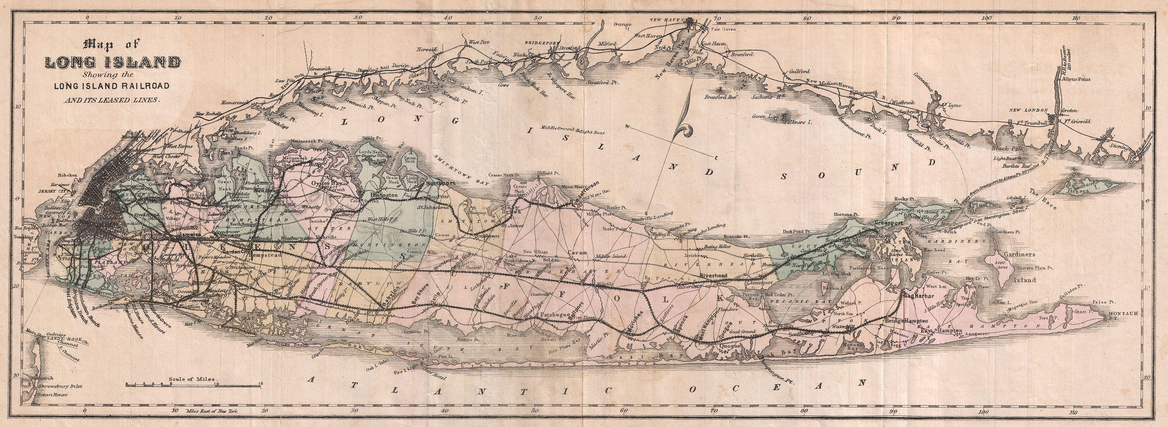
| J. H. Colton: Map of Long Island Showing the Long Isladn Railroad and its Leased Lines.
( |
|||||||||||||||||||||
|---|---|---|---|---|---|---|---|---|---|---|---|---|---|---|---|---|---|---|---|---|---|
| Artist |
|
||||||||||||||||||||
| Title |
Map of Long Island Showing the Long Isladn Railroad and its Leased Lines. |
||||||||||||||||||||
| Description |
English: A highly uncommon railroad map of Long Island, New York dating to 1882. Depicts Long Island in full inclusive of Manhattan, Brooklyn, the Long Island Sound, and the southern shore of Connecticut. Color coded in red, green, yellow and blue pastels at the county level. Shows the progress of the Long Island Railroad system as well as all important towns, bays, lighthouses, roads, and harbors. We have been able to identify only one other example of this map in the collections of the Library of Congress. Though the map is undated and has no clear assignation, Phillips attributes it to G.W. and C. B Colton. No doubt because it is clearly based on Colton’s 1855 “Traveller’s Map of Long Island” though conceivably Phillips and the Library of Congress had more information available regarding the map’s production than they published. |
||||||||||||||||||||
| Date | 1882 (undated) | ||||||||||||||||||||
| Dimensions | height: 8 in (20.3 cm); width: 21 in (53.3 cm) | ||||||||||||||||||||
| Accession number |
Geographicus link: LongIsland-colton-1882 |
||||||||||||||||||||
| Source/Photographer |
|
||||||||||||||||||||
| Permission (Reusing this file) |
|
||||||||||||||||||||

File history
Click on a date/time to view the file as it appeared at that time.
| Date/Time | Thumbnail | Dimensions | User | Comment | |
|---|---|---|---|---|---|
| current | 00:25, 25 March 2011 | 4,000 × 1,463 (1.57 MB) | BotMultichillT (talk | contribs) | {{subst:User:Multichill/Geographicus |link=http://www.geographicus.com/P/AntiqueMap/LongIsland-colton-1882 |product_name=1882 Colton Railroad Map of Long Island, New York |map_title=Map of Long Island Showing the Long Isladn Railroad and its Leased Lines. |
You cannot overwrite this file.
File usage on Commons
The following page uses this file: