File:1873 Stieler Map of the Eastern Hemisphere (Europe, Africa, Asia, Australia, Pacific) - Geographicus - EasternHemisphere-stieler-1873.jpg
Jump to navigation
Jump to search

Size of this preview: 688 × 600 pixels. Other resolutions: 275 × 240 pixels | 551 × 480 pixels | 881 × 768 pixels | 1,175 × 1,024 pixels | 2,350 × 2,048 pixels | 3,500 × 3,050 pixels.
Original file (3,500 × 3,050 pixels, file size: 1.87 MB, MIME type: image/jpeg)
Captions
Captions
Add a one-line explanation of what this file represents
| Justus Perthes: Oestliche Halbkugel
( |
||||||||||||||||||||||||
|---|---|---|---|---|---|---|---|---|---|---|---|---|---|---|---|---|---|---|---|---|---|---|---|---|
| Artist |
|
|||||||||||||||||||||||
| Title |
Oestliche Halbkugel |
|||||||||||||||||||||||
| Description |
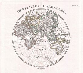
English: This is a beautiful example of Stieler’s 1873 map of the Eastern Hemisphere. Includes the entirety of Asia, Europe and Africa as well as Australia and much of the Pacific. Also includes those parts of Antarctica, including “Wilkes’ Land?”, that had been positively identified at the time. Rich in detail, as was typical of German, and especially Perthes/Stieler maps of this period. Published by the Justus Perthes firm and engraved by Johann Carl Ausfeld as plate no. 7 for issue in the 1873 edition of Stieler’s Hand-Atlas . |
|||||||||||||||||||||||
| Date | 1873 (dated) | |||||||||||||||||||||||
| Dimensions | height: 13.7 in (34.9 cm); width: 15.5 in (39.3 cm) | |||||||||||||||||||||||
| Accession number |
Geographicus link: EasternHemisphere-stieler-1873 |
|||||||||||||||||||||||
| Source/Photographer |
Stieler's Hand-Atlas (1873 issue).
|
|||||||||||||||||||||||
| Permission (Reusing this file) |
|
|||||||||||||||||||||||

File history
Click on a date/time to view the file as it appeared at that time.
| Date/Time | Thumbnail | Dimensions | User | Comment | |
|---|---|---|---|---|---|
| current | 07:58, 18 March 2011 | | 3,500 × 3,050 (1.87 MB) | BotMultichill (talk | contribs) | {{subst:User:Multichill/Geographicus |link=http://www.geographicus.com/P/AntiqueMap/EasternHemisphere-stieler-1873 |product_name=1873 Stieler Map of the Eastern Hemisphere (Europe, Africa, Asia, Australia, Pacific) |map_title=Oestliche Halbkugel |descript |
You cannot overwrite this file.
File usage on Commons
The following page uses this file:
_-_Geographicus_-_EasternHemisphere-stieler-1873.jpg)
_-_Geographicus_-_EasternHemisphere-stieler-1873.jpg&oldid=864629655)