File:1873 Stieler Map of Asia Minor, Syria and Israel - Palestine (modern Turkey) - Geographicus - Klein-AsienSyrien-stieler-1873.jpg
Jump to navigation
Jump to search

Size of this preview: 733 × 599 pixels. Other resolutions: 294 × 240 pixels | 587 × 480 pixels | 940 × 768 pixels | 1,253 × 1,024 pixels | 2,505 × 2,048 pixels | 4,000 × 3,270 pixels.
Original file (4,000 × 3,270 pixels, file size: 3.79 MB, MIME type: image/jpeg)
Captions
Captions
Add a one-line explanation of what this file represents
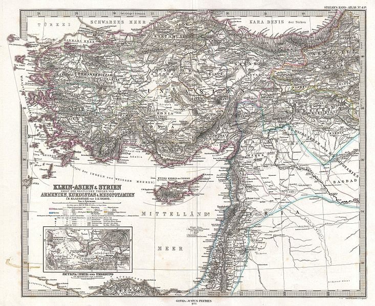
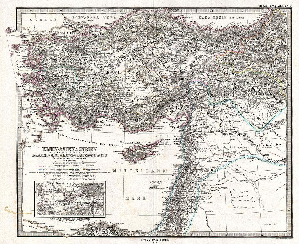
| Justus Perthes: Klein-Asien & Syrien nebst Den Westlichen Theilen von Armenien, Kurdistan & Mesopotamien.
( |
||||||||||||||||||||||||
|---|---|---|---|---|---|---|---|---|---|---|---|---|---|---|---|---|---|---|---|---|---|---|---|---|
| Artist |
|
|||||||||||||||||||||||
| Title |
Klein-Asien & Syrien nebst Den Westlichen Theilen von Armenien, Kurdistan & Mesopotamien. |
|||||||||||||||||||||||
| Description |
English: This is a beautiful example of Stieler’s 1873 map of the modern day Turkey, Syria, Israel / Palestine and Cyprus. Highly detailed with both political and physical data. Shows cities, mountains, roads, rivers and local divisions. An inset in the lower left quadrant features the vicinity of Smyrna (modern Ismir), including depth sounding in the Gulf of Smyrna and harbor. Printed to a high production standard, as was typical of German and especially Perthes/Stieler maps of this period. Published by the Justus Perthes firm and engraved by F. Eulenstein and C. Jungmann for issue as plate no. 43 in the 1873 edition of Stieler’s Hand-Atlas . |
|||||||||||||||||||||||
| Date | 1873 (dated) | |||||||||||||||||||||||
| Dimensions | height: 13.5 in (34.2 cm); width: 16.6 in (42.1 cm) | |||||||||||||||||||||||
| Accession number |
Geographicus link: Klein-AsienSyrien-stieler-1873 |
|||||||||||||||||||||||
| Source/Photographer |
Stieler's Hand-Atlas (1873 issue).
|
|||||||||||||||||||||||
| Permission (Reusing this file) |
|
|||||||||||||||||||||||

File history
Click on a date/time to view the file as it appeared at that time.
| Date/Time | Thumbnail | Dimensions | User | Comment | |
|---|---|---|---|---|---|
| current | 08:02, 18 March 2011 | | 4,000 × 3,270 (3.79 MB) | BotMultichill (talk | contribs) | {{subst:User:Multichill/Geographicus |link=http://www.geographicus.com/P/AntiqueMap/Klein-AsienSyrien-stieler-1873 |product_name=1873 Stieler Map of Asia Minor, Syria and Israel - Palestine (modern Turkey) |map_title=Klein-Asien & Syrien nebst Den Westlic |
You cannot overwrite this file.
File usage on Commons
The following page uses this file:
_-_Geographicus_-_Klein-AsienSyrien-stieler-1873.jpg)
File usage on other wikis
The following other wikis use this file:
- Usage on ar.wikipedia.org
- Usage on az.wikipedia.org
- Usage on bn.wikipedia.org
- Usage on en.wikipedia.org
- Usage on eo.wikipedia.org
- Usage on it.wikipedia.org
- Usage on ko.wikipedia.org
- Usage on mk.wikipedia.org
- Usage on mt.wikipedia.org
- Usage on pnb.wikipedia.org
- Usage on sl.wikipedia.org
- Usage on tr.wikipedia.org
- Usage on ur.wikipedia.org
_-_Geographicus_-_Klein-AsienSyrien-stieler-1873.jpg&oldid=818827161)