File:1871 - Hippolyte Malègue - Comparison Chart of the Main Mountains and Rivers in Haute-Loire.jpg
Jump to navigation
Jump to search

Size of this preview: 800 × 583 pixels. Other resolutions: 320 × 233 pixels | 640 × 467 pixels | 1,024 × 747 pixels | 1,280 × 934 pixels | 2,560 × 1,867 pixels | 9,858 × 7,190 pixels.
Original file (9,858 × 7,190 pixels, file size: 14.12 MB, MIME type: image/jpeg)
Captions
Captions
Add a one-line explanation of what this file represents
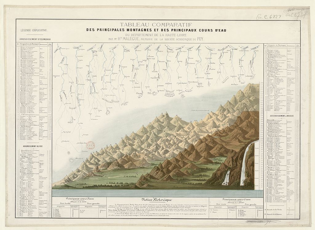
| English: Comparison Chart of the Main Mountains and Rivers in Haute-LoireFrançais : Tableau comparatif des principales montagnes et des principaux cours d'eau du département de la Haute-Loire
( |
|||||||||||||||||||||||||||
|---|---|---|---|---|---|---|---|---|---|---|---|---|---|---|---|---|---|---|---|---|---|---|---|---|---|---|---|
| Author |
Hippolyte Malègue |
||||||||||||||||||||||||||
| Title |
English: Comparison Chart of the Main Mountains and Rivers in Haute-Loire Français : Tableau comparatif des principales montagnes et des principaux cours d'eau du département de la Haute-Loire |
||||||||||||||||||||||||||
| Date | 1871 | ||||||||||||||||||||||||||
| Collection |
|
||||||||||||||||||||||||||
| Current location |
Département Cartes et plans |
||||||||||||||||||||||||||
| Accession number |
GE C-6727 |
||||||||||||||||||||||||||
| Source/Photographer | Gallica | ||||||||||||||||||||||||||
| Permission (Reusing this file) |
|
||||||||||||||||||||||||||

File history
Click on a date/time to view the file as it appeared at that time.
| Date/Time | Thumbnail | Dimensions | User | Comment | |
|---|---|---|---|---|---|
| current | 15:56, 14 June 2015 | | 9,858 × 7,190 (14.12 MB) | Poulpy (talk | contribs) | User created page with UploadWizard |
You cannot overwrite this file.
File usage on Commons
The following page uses this file: