File:1866 U.S.C.S. Map of Charleston Harbor, South Carolina - Geographicus - CharlestonHarbor-USCS-1866.jpg

Original file (5,000 × 4,824 pixels, file size: 2.92 MB, MIME type: image/jpeg)
Captions
Captions
| Charleston Harbor and its Approaches. | ||||||
|---|---|---|---|---|---|---|
| Artist | ||||||
| Title |
Charleston Harbor and its Approaches. |
|||||
| Description |
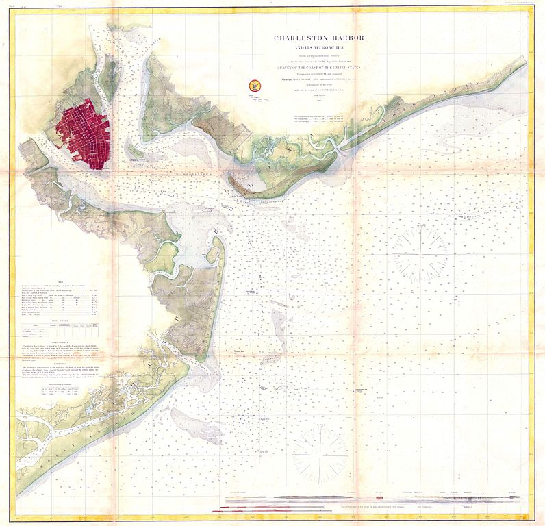
English: This is of the rarest and earliest obtainable large format depictions of Charleston Harbor and its approaches. Depicts the city of Charleston in a block layout with docks and some commercial buildings located. Places Hog Island, Drum Island, Shutes Folly Island, Morris Island, Sullivan’s Island, Long Island and James Island. Indicates, buoys, lighthouses, important channels and includes detailed depth soundings. View of North Channel and Fort Sumter. Details sailing instructions on left hand side of the map. Produced by the U.S. Coast Survey in 1866 (dated) under the direction of A. D. Bache. |
|||||
| Date | 1866 | |||||
| Dimensions | height: 31.5 in (80 cm); width: 32 in (81.2 cm) | |||||
| Accession number |
Geographicus link: CharlestonHarbor-USCS-1866 |
|||||
| Source/Photographer |
|
|||||
| Permission (Reusing this file) |
|
|||||
File history
Click on a date/time to view the file as it appeared at that time.
| Date/Time | Thumbnail | Dimensions | User | Comment | |
|---|---|---|---|---|---|
| current | 14:25, 24 March 2011 | | 5,000 × 4,824 (2.92 MB) | BotMultichillT (talk | contribs) | {{subst:User:Multichill/Geographicus |link=http://www.geographicus.com/P/AntiqueMap/CharlestonHarbor-USCS-1866 |product_name=1866 U.S.C.S. Map of Charleston Harbor, South Carolina |map_title=Charleston Harbor and its Approaches. |description=This is of th |
You cannot overwrite this file.
File usage on Commons
The following page uses this file: