File:1866 Post route map of the states of New Hampshire, Vermont, Massachusetts, Rhode Island, Connecticut, and parts of New York and Maine, by Walter L. Nicholson, Paul Goepel, D. McClelland, US Post Office, from the Digital Comm. - commonw.jpg
Jump to navigation
Jump to search

Size of this preview: 391 × 600 pixels. Other resolutions: 156 × 240 pixels | 313 × 480 pixels | 500 × 768 pixels | 667 × 1,024 pixels | 1,335 × 2,048 pixels | 12,215 × 18,743 pixels.
Original file (12,215 × 18,743 pixels, file size: 284.75 MB, MIME type: image/jpeg)
Captions
Captions
Add a one-line explanation of what this file represents
Summary
[edit]
| Warning | The original file is very high-resolution. It might not load properly or could cause your browser to freeze when opened at full size. |
|---|
| Description |
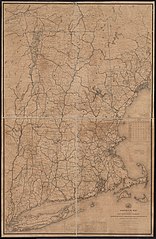
English: 1866 Post route map of the states of New Hampshire, Vermont, Massachusetts, Rhode Island, Connecticut, and parts of New York and Maine, by Walter L. Nicholson, Paul Goepel, D. McClelland, US Post Office, from the Digital Comm. - commonwealth 9s161j88f. (https://www.digitalcommonwealth.org/search/commonwealth:9s161j88f) |
| Date | |
| Source | Digital Commonwealth |
| Author | Walter L. Nicholson, Paul Goepel, D. McClelland, US Post Office |
Licensing
[edit]
|
This work is in the public domain in its country of origin and other countries and areas where the copyright term is the author's life plus 70 years or fewer. This work is in the public domain in the United States because it was published (or registered with the U.S. Copyright Office) before January 1, 1929. | |
| This file has been identified as being free of known restrictions under copyright law, including all related and neighboring rights. | |
File history
Click on a date/time to view the file as it appeared at that time.
| Date/Time | Thumbnail | Dimensions | User | Comment | |
|---|---|---|---|---|---|
| current | 19:36, 7 December 2021 | | 12,215 × 18,743 (284.75 MB) | Daderot (talk | contribs) | Uploaded a work by Walter L. Nicholson, Paul Goepel, D. McClelland, US Post Office from Digital Commonwealth with UploadWizard |
You cannot overwrite this file.
File usage on Commons
The following 2 pages use this file: