File:1866 Northern California Map.jpg
Jump to navigation
Jump to search

Size of this preview: 609 × 600 pixels. Other resolutions: 244 × 240 pixels | 487 × 480 pixels | 780 × 768 pixels | 1,040 × 1,024 pixels | 2,079 × 2,048 pixels | 3,000 × 2,955 pixels.
Original file (3,000 × 2,955 pixels, file size: 4.19 MB, MIME type: image/jpeg)
Captions
Captions
Add a one-line explanation of what this file represents
| Description |
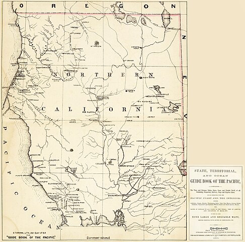
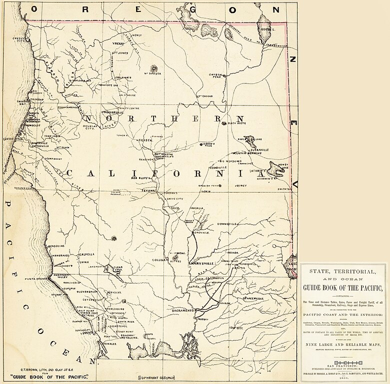
English: Historic map of Northern California in the 1860s (1866).
|
|||||||||||||
| Date | ||||||||||||||
| Source | http://www.davidrumsey.com as separate sheets | |||||||||||||
| Author | Holdredge, Sterling M., and Grafton Tyler Brown | |||||||||||||
| Permission (Reusing this file) |
|
|||||||||||||


| Object location | | View this and other nearby images on: OpenStreetMap |
|---|
File history
Click on a date/time to view the file as it appeared at that time.
| Date/Time | Thumbnail | Dimensions | User | Comment | |
|---|---|---|---|---|---|
| current | 16:53, 2 November 2013 | | 3,000 × 2,955 (4.19 MB) | Ellin Beltz (talk | contribs) | {{Information |Description ={{en|1=A photomontage by Ellin Beltz of separate sheet Northern California Maps from: Holdredge, Sterling M., and Grafton Tyler Brown. ''State, Territorial, and Ocean Guide Book of the Pacific: Con... |
You cannot overwrite this file.
File usage on Commons
The following page uses this file:
- File:1866NorthernCaliforniaMap.jpg (file redirect)
File usage on other wikis
The following other wikis use this file:
- Usage on en.wikipedia.org
- Usage on es.wikipedia.org
- Usage on www.wikidata.org
Metadata
Categories:
- 1866 maps of California
- Maps of Del Norte County, California
- Maps of Humboldt County, California
- Maps of Mendocino County, California
- Maps of Modoc County, California
- Maps of Napa County, California
- Maps of Plumas County, California
- Maps of Sacramento County, California
- Maps of Shasta County, California
- Maps of Siskiyou County, California
- Maps of Sonoma County, California
- Klamath County, California
- David Rumsey Historical Map Collection
- Grafton Tyler Brown
- Wars involving the indigenous peoples of North America in California
- Bald Hills War