File:1866 Johnson Map of New York City and Brooklyn - Geographicus - NewYorkCity2-johnson-1866.jpg
Jump to navigation
Jump to search

Size of this preview: 431 × 599 pixels. Other resolutions: 173 × 240 pixels | 345 × 480 pixels | 553 × 768 pixels | 737 × 1,024 pixels | 1,474 × 2,048 pixels | 2,879 × 4,000 pixels.
Original file (2,879 × 4,000 pixels, file size: 3.9 MB, MIME type: image/jpeg)
Captions
Captions
Add a one-line explanation of what this file represents
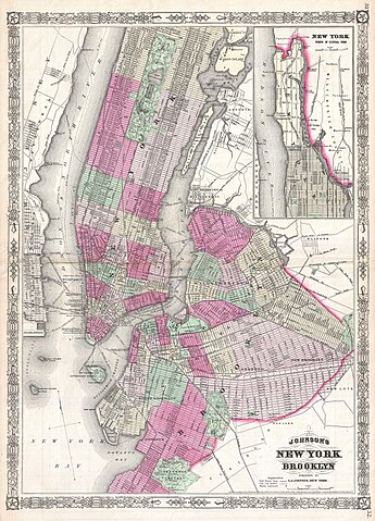
| Alvin Jewett Johnson: Johnson's New York and Brooklyn.
( |
|||||||||||||||||||||||
|---|---|---|---|---|---|---|---|---|---|---|---|---|---|---|---|---|---|---|---|---|---|---|---|
| Artist |
|
||||||||||||||||||||||
| Title |
Johnson's New York and Brooklyn. |
||||||||||||||||||||||
| Description |
English: This is A. J. Johnson’s attractive vertical plan of New York City. Depicts all of Manhattan, Brooklyn as it was at the time, and parts of Queens, Long Island City, Astoria, Jersey City and Hoboken. Covers Brooklyn from Greenwood Cemetery in the south northward to include Prospect Park, Bedford, Williamsburgh and Greenpoint. Extends eastward as far as Evergreen Cemetery. Detailed to the street level throughout showing individual piers, buildings and railroads. Shows many of the public buildings on Blackwell’s Island (Roosevelt Island) including the decrepit Civil War Hospital that still stands at the southern end of the Island. Both Central Park and Prospect Park are shown in stupendous detail according to the Olmstead Plans. Notes ferry crossings between Manhattan, Brooklyn and New Jersey. Johnson's original plan of New York, introduced in the 1862 edition of his atlas, was oriented from east to west. In 1866 Johnson re-engraved his New York City map giving it a rough north-south orientation. He goal in doing so was to accommodate interest in the Upper East and Upper West Sides, both of which, following the completion of Central Park, were rapidly developing. Surrounded by the fretwork border common to Johnson’s atlas maps from 1863 to 1869. Prepared as plates no. 31 and 32 for the 1866 issue of A. J. |
||||||||||||||||||||||
| Date | 1866 (dated) | ||||||||||||||||||||||
| Dimensions | height: 24 in (60.9 cm); width: 17 in (43.1 cm) | ||||||||||||||||||||||
| Accession number |
Geographicus link: NewYorkCity2-johnson-1866 |
||||||||||||||||||||||
| Source/Photographer |
Johnson, A. J., Johnson's New Illustrated Family Atlas. (1866 Johnson Edition)
|
||||||||||||||||||||||
| Permission (Reusing this file) |
|
||||||||||||||||||||||
File history
Click on a date/time to view the file as it appeared at that time.
| Date/Time | Thumbnail | Dimensions | User | Comment | |
|---|---|---|---|---|---|
| current | 16:49, 23 March 2011 | | 2,879 × 4,000 (3.9 MB) | BotMultichillT (talk | contribs) | {{subst:User:Multichill/Geographicus |link=http://www.geographicus.com/P/AntiqueMap/NewYorkCity2-johnson-1866 |product_name=1866 Johnson Map of New York City and Brooklyn |map_title=Johnson's New York and Brooklyn. |description=This is A. J. Johnson’s |
You cannot overwrite this file.
File usage on Commons
The following page uses this file: