File:1866 Johnson Map of Arabia, Persia, Turkey and Afghanistan (Iraq) - Geographicus - Arabia-johnson-1866.jpg
Original file (3,500 × 2,606 pixels, file size: 3.01 MB, MIME type: image/jpeg)
Captions
Captions
| Alvin Jewett Johnson: Johnson's Turkey in Asia Persia, Arabia & Co.
( |
|||||||||||||||||||||||
|---|---|---|---|---|---|---|---|---|---|---|---|---|---|---|---|---|---|---|---|---|---|---|---|
| Artist |
|
||||||||||||||||||||||
| Title |
Johnson's Turkey in Asia Persia, Arabia & Co. |
||||||||||||||||||||||
| Description |
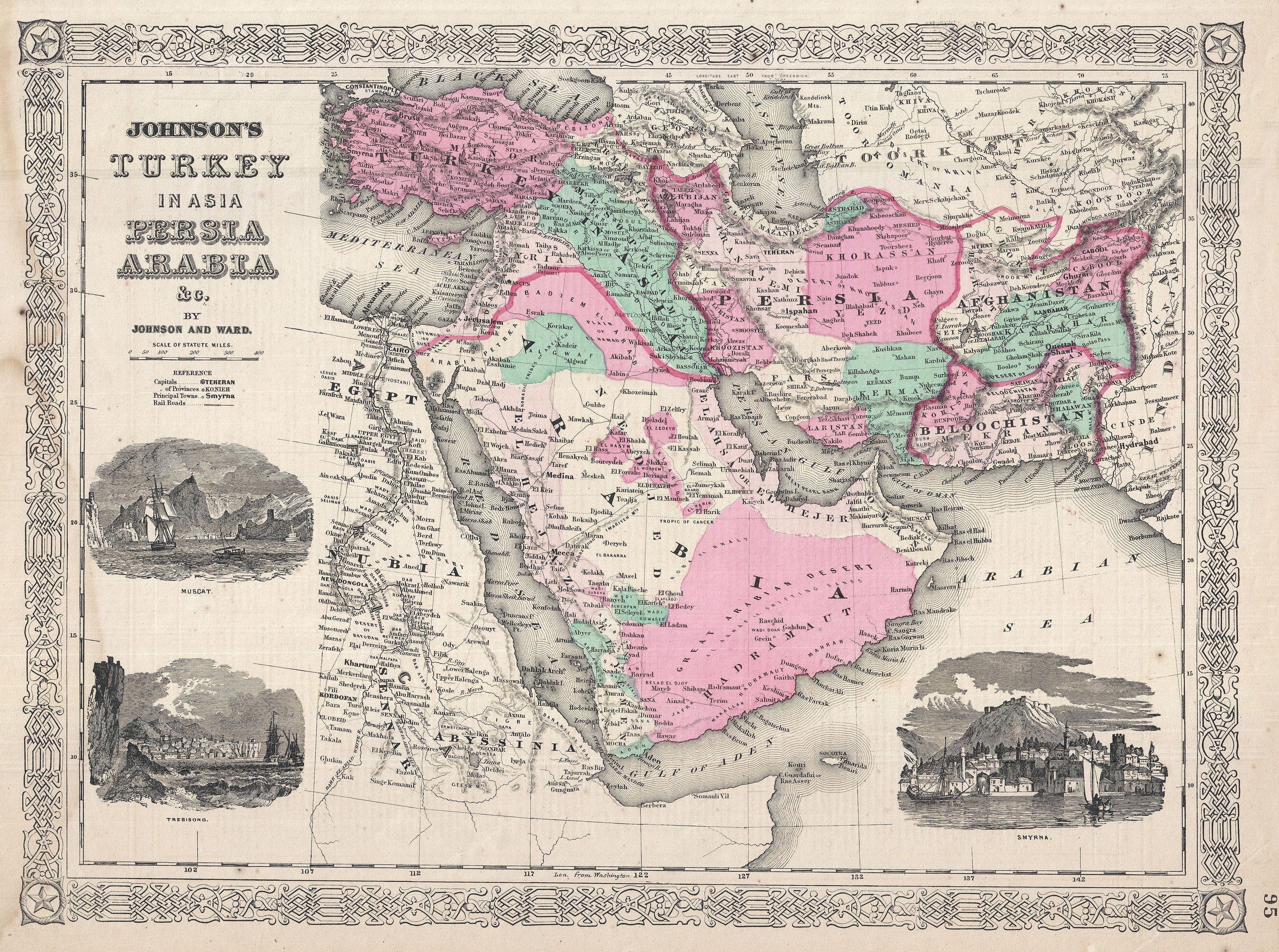
العربية: مثالٌ جميل عن خريطة وضعها آلڤين جونسون سنة 1866 لِبه الجزيرة العربيَّة، وفارس، والولايات العُثمانيَّة في آسيا. تُغطي هذه الخريطة المنطقة المُمتدة من البحر المُتوسِّط ومصر شرقًا وُصولًا إلى ثغر نهر السند، بالإضافة إلى المنطقة المُمتدة جنوبًا وُصولًا إلى القرن الأفريقي وشمالًا وُصولًا إلى البحر الأسود. تُظهر الخريطة مُعظم الدُول المُتقلِّبة سياسيًّا اليوم في الشرق الأوسط، بما فيها دُول أفغانستان، والعراق، وإيران، والسُعُوديَّة، والأُردُن، وإسرائيل - فلسطين المُحتلَّة، وسوريا، ولُبنان، وتُركيا. الخريطة مُقسَّمة بحسب الألوان إلى مناطق ودُول مُختلفة، وتظهر فيها دُرُوب قوافل الإبل الصحراويَّة، والواحات، والمسالك، والأنهار، والحُصُون، والأديرة، وبعض التضاريس الجُغرافيَّة. ظاهريًّا، تتشابه هذه الخريطة مع تلك الموضوعة من قِبل كلوتون سنة 1858 لِذات المنطقة، غير أنَّ المُدقق يُلاحظ بضعة اختلافات أساسيَّة. فقد عمل جونسون على تقليص خريطة كلوتون كي يتمكن من توسيع خريطته الخاصَّة غربًا بِمقدار 10 درجات، فأصبح بِمقدوره شمل كُل الولايات العُثمانيَّة الآسيويَّة وإضافة بعض التفاصيل المُهمَّة على شمال غرب أفريقيا ووادي النيل. سمحت نسخة جونسون بإضافة ثلاثة مطبوعات خشبيَّة جذَّابة: مسقط (أعلى اليسار)، طرابزون (أسفل اليسار) وحصن ومرفأ سميرنا (أسفل اليمين).
English: A very nice example of A. J. Johnson’s 1866 map of Arabia, Persia and Turkey in Asia. Covers from the Mediterranean and Egypt eastwards as far as the Mouths of the Indus River, as well as southward as far as the Horn of Africa and northwards to the Black Sea. Depicts most of the politically volatile modern day middle east, including the nations of Afghanistan, Iraq, Iran, Saudi Arabia, Jordan, Israel, Syria, Lebanon and Turkey. Offers color coding according to country and region as well as notations regarding desert caravan routes, oases, roadways, river systems, forts and monasteries, and some topographical features. Ostensibly this map is very similar to Colton's 1858 map of the same region, however, there are a number of significant differences. Johnson reduced Colton's original map in order to expand the map westward by about 10 degrees, making it possible for him to incorporate all of Turkey as well as add significant detail in northwestern Africa and the Nile Valley. Johnson's retooling of the map also allowed for the addition of his three attractive woodcut views: Muscat (lower left), Trebisond (lower left) and the Castle and Port of Smyrna (lower right). Features the fretwork style border common to Johnson’s atlas work from 1864 to 1869. Published by A. J. Johnson and Ward as plate number 95 in the 1865 edition of Johnson’s New Illustrated Family Atlas. This is the last edition of the Family Atlas to bear the Johnson and Ward imprint. |
||||||||||||||||||||||
| Date | 1866 (undated) | ||||||||||||||||||||||
| Dimensions | height: 13 in (33 cm); width: 16.5 in (41.9 cm) | ||||||||||||||||||||||
| Accession number |
Geographicus link: Arabia-johnson-1866 |
||||||||||||||||||||||
| Source/Photographer |
Johnson, A. J., Johnson's New Illustrated Family Atlas of The World with Physical Geography, and with Descriptions Geographical, Statistical, and Historic including The Latest Federal Census, A Geographical Index, and a Chronological History of the Civil War in America, 1866.
|
||||||||||||||||||||||
| Permission (Reusing this file) |
|
||||||||||||||||||||||
|
_-_Geographicus_-_Arabia-johnson-1866.jpg)
File history
Click on a date/time to view the file as it appeared at that time.
| Date/Time | Thumbnail | Dimensions | User | Comment | |
|---|---|---|---|---|---|
| current | 20:39, 23 March 2011 | | 3,500 × 2,606 (3.01 MB) | BotMultichillT (talk | contribs) | {{subst:User:Multichill/Geographicus |link=http://www.geographicus.com/P/AntiqueMap/Arabia-johnson-1866 |product_name=1866 Johnson Map of Arabia, Persia, Turkey and Afghanistan (Iraq) |map_title=Johnson's Turkey in Asia Persia, Arabia & Co. |description=A |
You cannot overwrite this file.
File usage on Commons
The following page uses this file:
_-_Geographicus_-_Arabia-johnson-1866.jpg)
File usage on other wikis
The following other wikis use this file:
- Usage on ar.wikipedia.org
- أبو عريش
- الشرق الأوسط
- بوابة:الدولة العثمانية/صورة
- ويكيبيديا:صور مختارة/رسومات وجداول وخرائط/خرائط
- ويكيبيديا:ترشيحات الصور المختارة/خريطة قديمة للشرق الأوسط
- ويكيبيديا:صورة اليوم المختارة/يناير 2018
- قالب:صورة اليوم المختارة/2018-01-30
- بوابة:الدولة العثمانية/صورة مختارة/40
- ويكيبيديا:صورة اليوم المختارة/يناير 2020
- قالب:صورة اليوم المختارة/2020-01-15
- ويكيبيديا:صورة اليوم المختارة/نوفمبر 2022
- قالب:صورة اليوم المختارة/2022-11-17
- Usage on fa.wikipedia.org
- خاورمیانه
- شهرستان میانه
- تحریف نام خلیج فارس
- ویکیپدیا:نگارههای برگزیده/نقشه
- ویکیپدیا:نگاره روز/فوریه ۲۰۱۸
- ویکیپدیا:گزیدن نگاره برگزیده/دسامبر-۲۰۱۷
- ویکیپدیا:گزیدن نگاره برگزیده/1866 Johnson Map of Arabia, Persia, Turkey and Afghanistan (Iraq) - Geographicus - Arabia-johnson-1866.jpg
- الگو:نر/2018-02-28
- الگو:نر محافظت شده/2018-02-28
_-_Geographicus_-_Arabia-johnson-1866.jpg)
_-_Geographicus_-_Arabia-johnson-1866.jpg&oldid=876875466)