File:1862 Johnson and Ward Map or Chart of the World's Mountains and Rivers - Geographicus - MtsRvrs-j-1861.jpg
Jump to navigation
Jump to search

Size of this preview: 800 × 570 pixels. Other resolutions: 320 × 228 pixels | 640 × 456 pixels | 1,024 × 730 pixels | 1,280 × 912 pixels | 2,560 × 1,824 pixels | 4,000 × 2,850 pixels.
Original file (4,000 × 2,850 pixels, file size: 3.54 MB, MIME type: image/jpeg)
Captions
Captions
Add a one-line explanation of what this file represents
| Alvin Jewett Johnson: Mountains & Rivers
( |
|||||||||||||||||||||||
|---|---|---|---|---|---|---|---|---|---|---|---|---|---|---|---|---|---|---|---|---|---|---|---|
| Artist |
|
||||||||||||||||||||||
| Title |
Mountains & Rivers |
||||||||||||||||||||||
| Description |
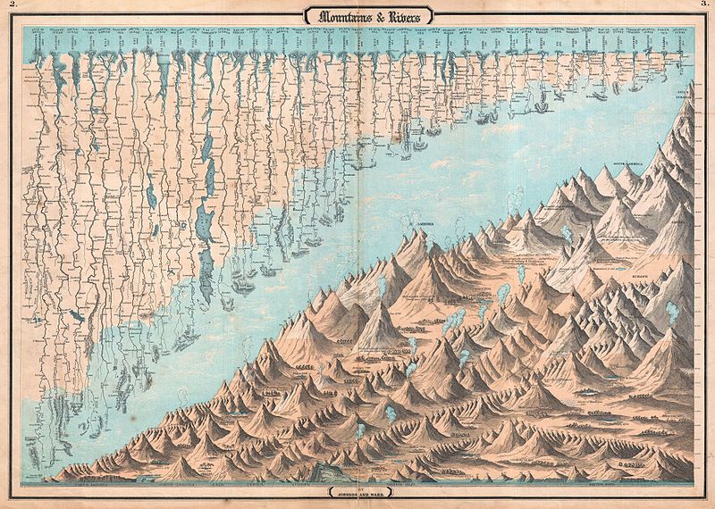
English: One of the finest Mountains and River’s Chart published in the mid 19th century. This is the 1862 edition of Johnson and Ward chart or map of the relative distances of the world’s great rivers and the relative heights of the world’s great mountains. Includes a multitude of details regarding the heights of important cities, glaciers, volcanoes, and tree lines. Chart even includes Niagara Falls, the Great Pyramid, St. Peter’s Basilica in Rome and St. Paul’s in London. It is extremely rare to find this map such fine condition as this one because it was issued at the front of Johnson’s Atlas, where most of the heavy damage from moisture, soiling, and general use was sustained. Based upon a similar map copyrighted by J. H. Colton in 1855. Prepared by Johnson and Ward for the 1862 issue as plate nos. 2-3 in Johnson’s New Illustrated Family Atlas. |
||||||||||||||||||||||
| Date | 1862 (undated) | ||||||||||||||||||||||
| Dimensions | height: 17 in (43.1 cm); width: 24 in (60.9 cm) | ||||||||||||||||||||||
| Accession number |
Geographicus link: MtsRvrs-j-1861 |
||||||||||||||||||||||
| Source/Photographer |
Johnson's New Illustrated Family Atlas, (1862 Johnson and Ward edition)
|
||||||||||||||||||||||
| Permission (Reusing this file) |
|
||||||||||||||||||||||
File history
Click on a date/time to view the file as it appeared at that time.
| Date/Time | Thumbnail | Dimensions | User | Comment | |
|---|---|---|---|---|---|
| current | 23:55, 24 March 2011 | | 4,000 × 2,850 (3.54 MB) | BotMultichillT (talk | contribs) | {{subst:User:Multichill/Geographicus |link=http://www.geographicus.com/P/AntiqueMap/MtsRvrs-j-1861 |product_name=1862 Johnson and Ward Map or Chart of the World's Mountains and Rivers |map_title=Mountains & Rivers |description=One of the finest Mountains |
You cannot overwrite this file.
File usage on Commons
The following page uses this file:
File usage on other wikis
The following other wikis use this file:
- Usage on fr.wikipedia.org